Gare de Paris-Est
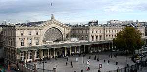
Paris Est (or Gare de l'Est, "East station" in English) is one of the six large SNCF termini in Paris. It is in the 10th arrondissement, not far from the Gare du Nord, facing the Boulevard de Strasbourg, part of the north-south axis of Paris created by Baron Haussmann. It is one of the largest and the oldest railway stations in Paris, the western terminus of the Paris–Strasbourg railway and the Paris–Mulhouse railway.
History

The Gare de l'Est was opened in 1849 by the Compagnie du Chemin de Fer de Paris à Strasbourg (the Paris-Strasbourg Railway Company) under the name "Strasbourg platform." This platform corresponds today with the hall for main-line trains, and was designed by the architect François Duquesnay. It was renamed the "Gare de l'Est" in 1854, after the expansion of service to Mulhouse.
Renovations to the station followed in 1885 and 1900. In 1931 it was doubled in size, with the new part of the station built symmetrically with the old part. This transformation changed the surrounding neighborhood significantly.
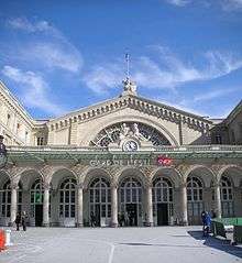
At the top of the west façade of the Gare de l'Est is a statue by the sculptor Philippe Joseph Henri Lemaire, representing the city of Strasbourg, while the east end of the station is crowned by a statue personifying Verdun, by Varenne. These two cities are important destinations serviced by Gare de l'Est.
On 4 October 1883, the Gare de l'Est saw the first departure of the Orient Express for Istanbul.
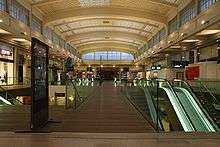
The Gare de l'Est is the terminus of a strategic railway network extending towards the eastern part of France, and it saw large mobilizations of French troops, most notably in 1914, at the beginning of World War I. In the main-line train hall, a monumental painting by Albert Herter, dating from 1926, illustrates the departure of these soldiers for the Western front.
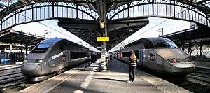
SNCF started LGV Est Européenne services from the Gare de l'Est on 10 June 2007, with TGV and ICE services to north-eastern France, Luxembourg, southern Germany and Switzerland. Trains are initially planned to run at 320 km/h (198 mph), with the potential to run at 350 km/h (217 mph), cutting travel times by up to 2 hours.
Train services
The following services currently call at Paris-Est:
- EuroNight Paris Est - Hannover - Berlin - Warsaw - Brest - Minsk - Moscow
- High speed services TGV Paris Est - Reims
- High speed services TGV Paris Est - Reims - Charleville-Mézières - Sedan
- High speed services TGV Paris Est - Champagne Adrennes TGV - Chalons-en-Champagne - Bar-le-Duc
- High speed services TGV Paris Est - (Champagne Ardennes TGV/Meuse TGV) - Nancy
- High speed services TGV Paris Est - Nancy - Epinal - Remiremont
- High speed services TGV Paris Est - Nancy - St Dié des Vosges
- High speed services TGV Paris Est - Nancy - Strasbourg
- High speed services TGV Paris Est - (Meuse TGV) - Metz
- High speed services TGV Paris Est - Metz - Thionville - Luxembourg
- High speed services TGV/ICE Paris Est - Saarbrücken - Kaiserslautern - Mannheim - Frankfurt
- High speed services TGV Paris Est - (Saverne) - Strasbourg
- High speed services TGV Paris Est - Strasbourg - Colmar
- High speed services TGV/ICE Paris Est - Strasbourg - Karlsruhe - Stuttgart
- High speed services TGV/ICE Paris Est - Strasbourg - Karlsruhe - Stuttgart - Ulm - Augsburg - Munich
- Intercity services Paris Est - Troyes - Chaumont - Culmont-Chalindrey - Vesoul - Belfort
- Regional services TER Picardie Paris Est - Chateau-Thierry - Épernay - Chalons-en-Champagne - Bar-le-Duc
- Regional services TER Champagne-Ardenne Paris Est - Chateau-Thierry - Épernay - Chalons-en-Champagne - St Dizier
- Regional services Transilien Paris Est - Meaux - Chateau Thierry
- Regional services Transilien Paris Est - Meaux - La Ferte-Milon
- Regional services Transilien Paris Est - Chelles Gournay - Meaux
- Regional services Transilien Paris Est - Tournan - Coulommiers
- Regional services Transilien Paris Est - Longueville - Provins
| Series | Route |
|---|---|
| TGV | Paris-Est - Reims - Rethel - Charleville-Mézières - Sedan |
| TGV | Paris-Est - Nancy-Ville - Lunéville - Saint-Dié-des-Vosges |
Metro Services
- Métro:
- Lines 4 (Porte de Clignancourt—Porte d'Orléans) and 5 (Place d'Italie - Bobigny – Pablo Picasso): service to the Gare du Nord.
- Line 7 (La Courneuve – 8 Mai 1945-Mairie d'Ivry/Villejuif – Louis Aragon (Paris Métro))
- Travelling between Gare de l'Est and other Paris main line stations:
- Gare du Nord: Walk to the station, or take Métro Line 4 or 5.
- Gare Montparnasse: Take Métro Line 4.
- Gare de Lyon: Take Métro Line 4 to Châtelet and then Line 1, 14 or RER A to Gare de Lyon, or take bus 65.
- Gare d'Austerlitz: Take Métro Line 5.
- Gare Saint-Lazare: Take Métro Line 7 to Opéra and then Line 3 to Saint-Lazare, or take RER E from Magenta (connected to Gare du Nord).
- Travelling to points of interest
- Disneyland Paris:Take Métro Line 4 to Gare de Châtelet – Les Halles then take the RER Line A to Marne-la-Vallée – Chessy.
Important destinations served by trains from the Gare de l'Est
See also
| Wikimedia Commons has media related to Gare de l'Est. |
- List of stations of the Paris RER
- List of stations of the Paris Métro
- TER Champagne-Ardenne
- Transilien Network Map
- Transilien
Coordinates: 48°52′37″N 2°21′33″E / 48.87694°N 2.35917°E
Paris rail stations | |||||||||||||||||||
|---|---|---|---|---|---|---|---|---|---|---|---|---|---|---|---|---|---|---|---|
| Termini |
|  | |||||||||||||||||
| SNCF stations | |||||||||||||||||||
| RER stations | |||||||||||||||||||
See also: List of stations of the Paris Métro, Tramways in Île-de-France, and Transport in Paris. There is also an external interactive map. | |||||||||||||||||||