Gehrdener Berg
| Gehrdener Berg | |
|---|---|
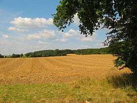 The Gehrdener Berg in late summer | |
| Highest point | |
| Elevation | 155 m above sea level (NN) (509 ft) |
| Prominence | 70 m → Deister |
| Isolation | 3.1 km → Benther Berg |
| Coordinates | 52°18′29″N 9°35′24″E / 52.30806°N 9.59°ECoordinates: 52°18′29″N 9°35′24″E / 52.30806°N 9.59°E |
| Geography | |
 Gehrdener Berg | |
The Gehrdener Berg is a forested ridge in the Calenberg Land in Hanover Region in the north German state of Lower Saxony. On its slopes nestles the town of Gehrden that gives the ridge its name. The ridge is about 2.7 kilometres long and is the sister hill range of the Benther Berg in southwest Hanover. Its highest point is the Burgberg at 155 metres above sea level (NN).
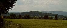
The Gehrdener Berg with the Deister in the background
Sources
- Werner Fütterer: Gehrden – Vom Flecken zur Großgemeinde. Gehrden 1991
- August Kageler: Geschichte der Stadt Gehrden. Gehrden 1950
External links
| Wikimedia Commons has media related to Gehrdener Berg. |
This article is issued from Wikipedia - version of the 12/6/2015. The text is available under the Creative Commons Attribution/Share Alike but additional terms may apply for the media files.