GenGIS
|
Biodiveristy of 19 marine metagenomes from the Global Ocean Sampling Expedition. | |
| Developer(s) | Donovan Parks, Mike Porter, Timothy Mankowski, Suwen Wang, Sylvia Churcher, Alex Keddy, Christian Blouin, Jacqueline Whalley, Stephen Brooks, Rob Beiko |
|---|---|
| Stable release |
2.4.1
/ 2015 |
| Operating system | Windows, Mac OS X |
| Type | Bioinformatics |
| License | GPL v3 |
| Website | http://kiwi.cs.dal.ca/GenGIS |
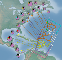
GenGIS[1] merges geographic, ecological and phylogenetic biodiversity data in a single interactive visualization and analysis environment. A key feature of GenGIS is the testing of geographic axes that can correspond to routes of migration or gradients that influence community similarity.[2] Data can also be explored using graphical summaries of data on a site-by-site basis, as 3D geophylogenies, or custom visualizations developed using a plugin framework. Standard statistical test such as linear regression and Mantel are provided, and the R statistical language can be accessed directly within GenGIS. Since its release, GenGIS has been used to investigate the phylogeography of viruses and bacteriophages, bacteria, and eukaryotes.
See also
References
- ↑ Parks, DH; Porter M; Churcher S; Wang S; Blouin C; Whalley J; Brooks S; Beiko RG (2009). "GenGIS: A geospatial information system for genomic data". Genome Research. 19: 1896–1904. doi:10.1101/gr.095612.109.
- ↑ Parks, DH; Beiko RG (2009). "Quantitative visualizations of hierarchically organized data in a geographic context". Geoinformatics, Fairfax, VA: 1–6.
External links
This article is issued from Wikipedia - version of the 11/26/2015. The text is available under the Creative Commons Attribution/Share Alike but additional terms may apply for the media files.