Geology of Illinois
The strata of the bedrock geology of Illinois are dominated by Pennsylvanian age rocks which occur within the Illinois Basin.
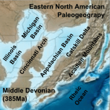
Illinois Basin
The Illinois Basin is a northwest-southeast asymmetrical structural basin that is filled with more than 4000 meters of Paleozoic sedimentary rocks. The basin covers most of Illinois, and extends into western Indiana and western Kentucky. The basin is bounded to the north by the Mississippi River and the Kankakee Arch, to the east by the Cincinnati Arch, and to the south by the Ozark uplift and Pascola Arch.[2]
Rocks
The oldest rocks exposed in Illinois, are Cambrian, and occur along the Rock River in Ogle County. The youngest are Tertiary (Eocene) and occur in southwestern Illinois. Cretaceous Period sediments onlap the Paleozoic units in extreme southern Illinois.
A bedrock geologic map was published by Kolata et al., 2005 and is available at the Illinois State Geological Survey.[3]
References
- ↑ Blakey, Ron. "Paleogeography and Geologic Evolution of North America". Global Plate Tectonics and Paleogeography. Northern Arizona University. Retrieved 2008-07-04.
- ↑ McDowell, R.C., (ed.), 2001, The geology of Kentucky -- A text to accompany the geologic map of Kentucky: USGS Professional Paper 1151-H, 68 p.
- ↑ Kolata, D.R.(compiler) 2005, Bedrock Geology of Illinois, Illinois State Geological Survey, Illinois Map 14, 1:500,000 scale. Contributions by: Denny, F.B., Devera, J.A., Hansel, A.K., Jacobson, R.J., Lasemi, Z., McGarry, C.S., Nelson, W.J., Norby, R.D., Treworgy, C.G., and Weibel, C.P.