1940 South Carolina hurricane
| Category 2 hurricane (SSHWS/NWS) | |
| Formed | August 5, 1940 |
|---|---|
| Dissipated | August 15, 1940 |
| Highest winds |
1-minute sustained: 100 mph (155 km/h) |
| Lowest pressure | 972 mbar (hPa); 28.7 inHg |
| Fatalities | 50 direct, 2 indirect |
| Damage | $13 million (1940 USD) |
| Areas affected | Georgia, South Carolina, North Carolina, Tennessee, Virginia |
| Part of the 1940 Atlantic hurricane season | |
The 1940 South Carolina hurricane was a Category 2 hurricane that struck the Georgia and South Carolina coast between August 11 and 12, 1940. After forming north of the Leeward Islands, the storm moved west-northwest, moving east of the Bahamas before resuming a west-northwest track towards the Southeastern United States. Hurricane warnings were in effect for the United States coastline near and north of where the center made landfall. A 13-foot storm tide was measured along the South Carolina coast, while over 15 inches (380 mm) of rain fell across northern North Carolina. Significant flooding and landslides struck Georgia, North Carolina, Tennessee, and Virginia during the system's slow trek as a weakening tropical storm, and then as an extratropical cyclone, through the Southeast. The landslides which struck North Carolina were considered a once in a century event. Damages relating to the storm totaled $13 million (1940 USD) and 50 people perished.
Meteorological history

Morning weather charts detected a "slight" disturbance between St. Martin and St. Thomas on August 5.[1] Around 18:00 UTC that day, a tropical depression developed about 30 mi (48 km) west-northwest of Anegada in the British Virgin Islands.[2]
The storm moved moving west-northwest near the Mona Passage, bringing squalls of 44 miles per hour (71 km/h) to San Juan, Puerto Rico. On August 6, the developing storm was near the southeastern Bahamas, bringing moderate to rough seas. The cyclone turned northward after its close approach to the southeastern Bahamas. By August 10 a ship reported that winds were hurricane force. In the afternoon of August 11, the hurricane made landfall near Beaufort, South Carolina where it moved inland and turned just northeast of Savannah, Georgia between 5 and 6 p.m. on the same day. Savannah's wind peaked at 73 miles per hour (117 km/h) and the pressure fell to 28.78 inches of mercury (975 hPa). It was the area's worst storm in 29 years.[3] Hurricane-force winds were witnessed between Savannah and Charleston. Weakening into a tropical storm that evening, for the next four or five days the storm meandered inland as a weak tropical storm before evolving into an extratropical cyclone on the evening of August 14.[2]
Preparations and impact
From August 7 and 9, small craft were advised to exercise caution over the eastern Bahamas and western subtropical Atlantic Ocean as the system approached the region.[4][5][6] By 9:30 a.m. on August 10, small craft warnings were in effect for the extreme northern Bahamas, and along the United States coast from Miami, Florida to Cape Hatteras, North Carolina.[7] By the morning of August 11, storm warnings were in effect from Wilmington, North Carolina northward to Cape Hatteras and from Savannah, Georgia to Fernandina Beach, Florida. Hurricane warnings were in effect from Savannah northward to Wilmington.[8] All coastal warnings were dropped by August 12.[9]
A storm tide of 13 feet (4.0 m) was measured along the coast of South Carolina.[10] The cyclone inflicted $1.5 million in damage in Charleston, South Carolina, while Savannah, Georgia received $1 million in damage. Damage to the coastline totaled $3 million (1940 USD). Two people in Georgia died from heart failure.[1] Near the point of landfall, a total of 10.84 inches (275 mm) of rainfall fell at Beaufort, South Carolina within a 24-hour period.[11] The highest reported rainfall amount in Georgia was recorded was 13.68 inches (347 mm) one mile east of Louisville while the highest amount in South Carolina was reported from Charleston, where 12.66 inches (322 mm) fell.[12] On the coastal areas where the hurricane was hit there was a considerable loss of life. Early press reports said that 35 were dead. According to the Monthly Weather Review, the deaths were low because of hurricane warnings and evacuations. However, modern sources indicate that 50 people died during this storm.[13]
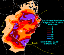
After leaving the coast, the dissipating storm brought heavy rains that sparked disastrous flash floods. The floods inundated much of Tennessee, the Carolinas and northern Georgia. Rainfall amounts across western North Carolina exceeded 15 inches (380 mm), with the highest amount recorded at Idlewild, where 20.65 inches (525 mm) fell.[12] Landslides were common in the mountains of western North Carolina, where it is considered a once in over 100 year landslide event.[14] The East Tennessee and Western North Carolina railroad line was severed so badly it ceased operation.[15] The peak discharge of the flood along Wilson Creek near Adako, North Carolina was estimated at 99,000 cubic feet per second (2,800 m3/s).[16] A total of 26 perished during the Deep Gap Debris Flow in Watauga County, North Carolina alone.[17] Major portions of the county were cut off for two weeks. Debris flows and flooding cut off U.S. Highway 421 in 21 places through a six-mile stretch of roadway between Deep Gap and Maple Springs in Wilkes County, North Carolina. Flooding destroyed 90% of the bridges in Caldwell County, North Carolina.[18] Press reports stated that 30 people died in the floods. Damage amounted to over $10 million (1940 USD).[19]
Rains began in Virginia on August 13, as the system entered the state from the west. Deluges flooded locations across southern and western sections of the Old Dominion. Hampton Roads measured 4.76 inches (121 mm) of rainfall. The highest rainfall amount statewide was recorded at Copper Hill, where 17.03 inches (433 mm) fell.[20] Emporia, on the Meherrin River, recorded a flood of record on August 17 when the river crested at 31.50 feet (9.60 m), which was 8.5 feet (2.6 m) feet above flood stage. Mountain rivers and streams overflowed, washing out bridges and causing landslides which blocked roads. Several highways between Norfolk, southwest Virginia, and Asheville, North Carolina were closed. A collision on August 13 involving the oil screw F.B. Scarbrough 5 miles (8.0 km) above Coles Point may have been caused by this system.[21]
See also
References
- 1 2 Jean H. Galenne (1940). Tropical Disturbances of August 1940 (PDF) (Report). American Meteorological Society. pp. 217–218.
- 1 2 National Hurricane Center; Hurricane Research Division (July 6, 2016). "Atlantic hurricane best track (HURDAT version 2)". United States National Oceanic and Atmospheric Administration. Retrieved December 5, 2016.
- ↑ Ivan Ray Tannehill (1943). Hurricanes. Princeton University Press. pp. 250–251.
- ↑ United States Weather Bureau (August 7, 1940). "Daily Weather Maps: August 7, 1940". United States Department of Commerce. Retrieved December 23, 2009.
- ↑ United States Weather Bureau (August 8, 1940). "Daily Weather Maps: August 8, 1940". United States Department of Commerce. Retrieved December 23, 2009.
- ↑ United States Weather Bureau (August 9, 1940). "Daily Weather Maps: August 9, 1940". United States Department of Commerce. Retrieved December 23, 2009.
- ↑ United States Weather Bureau (August 10, 1940). "Daily Weather Maps: August 10, 1940". United States Department of Commerce. Retrieved December 23, 2009.
- ↑ United States Weather Bureau (August 11, 1940). "Daily Weather Maps: August 11, 1940". United States Department of Commerce. Retrieved December 23, 2009.
- ↑ United States Weather Bureau (August 12, 1940). "Daily Weather Maps: August 12, 1940". United States Department of Commerce. Retrieved December 23, 2009.
- ↑ Stephen P. Leatherman (1994). "Hurricane Hugo, Puerto Rico, the Virgin Islands, and Charleston, South Carolina, September 17–22, 1989". Commission on Engineering and Technical Systems. p. 213. Retrieved June 18, 2009.
- ↑ South Carolina State Climatology Office (2009). "South Carolina Hurricane Climatology". South Carolina Department of Natural Resources. Retrieved June 18, 2009.
- 1 2 Roth, David M; Hydrometeorological Prediction Center. "Tropical Cyclone Rainfall in the Southeastern United States". Tropical Cyclone Rainfall Point Maxima. United States National Oceanic and Atmospheric Administration's National Weather Service. Retrieved June 5, 2012.
- ↑ Eric S. Blake; Edward N. Rappaport; Christopher W. Landsea (April 15, 2007). "NOAA Technical Memorandum NWS TPC-5: The Deadliest, Costliest, and Most Intense United States Tropical Cyclones From 1851 to 2006 (and Other Frequently Requested Hurricane Facts)" (PDF). National Hurricane Center. p. 7. Retrieved December 23, 2009.
- ↑ Richard Wooten (August 2004). "Geologic hazards: Dates, Level of Events, Damage and Indirect Costs". North Carolina Geological Survey. Archived from the original on August 2, 2008. Retrieved June 19, 2009.
- ↑ Peter John Robinson (2005). North Carolina weather & climate. University of North Carolina Press. p. 121. ISBN 978-0-8078-5625-3. Retrieved June 18, 2009.
- ↑ United States Geological Survey (October 14, 2008). "Wilson Creek near Adako, North Carolina" (PDF). pp. 149–150. Retrieved June 18, 2009.
- ↑ North Carolina Geological Survey (February 19, 2008). "Geologic hazards in North Carolina — Landslides". Retrieved June 18, 2009.
- ↑ "Laurelmor and Landslides". Western North Carolina Landslide Advisory Website. March 5, 2008. Retrieved June 18, 2009.
- ↑ Millsboro Daily News (August 16, 1940). "Floods Surge Toward Surge". Archived from the original on January 14, 2016. Retrieved March 23, 2008.
- ↑ Roth, David M; Weather Prediction Center (2012). "Tropical Cyclone Rainfall in the Mid-Atlantic United States". Tropical Cyclone Rainfall Point Maxima. United States National Oceanic and Atmospheric Administration's National Weather Service. Retrieved June 23, 2012.
- ↑ Roth, David M (1999). Virginia Hurricane History: Early Twentieth Century. Retrieved June 19, 2009.
External links