Georgian Bay Islands National Park
| Georgian Bay Islands National Park | |
|---|---|
|
IUCN category II (national park) | |
|
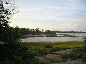
Cedar Springs, Beausoleil Island | |
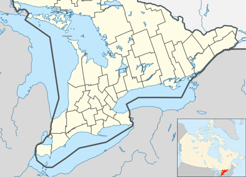 Location of Georgian Bay Islands National Park in Canada | |
| Location | Ontario, Canada |
| Nearest city | Midland, Ontario |
| Coordinates | 44°52′40″N 79°52′29″W / 44.87778°N 79.87472°WCoordinates: 44°52′40″N 79°52′29″W / 44.87778°N 79.87472°W |
| Area | 13.5 km2 (5.2 sq mi) |
| Established | 1929 |
| Governing body | Parks Canada |
Georgian Bay Islands National Park consists of 63 small islands or parts of islands in Georgian Bay, near Port Severn, Ontario. The park was established in 1929. The total park area is approximately 13.5 km2 (5.2 sq mi). Prior to the creation of Fathom Five National Marine Park, Flowerpot Island was also a part of the park.[1]
The islands blend the exposed rocks and pines of the Canadian Shield with the hardwood forests found further south. The park can only be reached by boat; there are limited camping facilities on the largest island, Beausoleil Island.
The park provides habitat for 33 species of reptiles and amphibians, including the threatened eastern Massasauga Rattlesnake. Some of the more isolated islands provide nesting areas for colonies of gulls and terns.
The park is part of the Georgian Bay Littoral Biosphere Reserve.
Beausoleil Island
Beausoleil Island is the largest island in the park and it offers island tent camping, overnight and day docking, heritage education programs, and hiking trails. Wheelchair accessible sites and reserved campsites are also available at the Cedar Spring campground on Beausoleil Island.
See also
References
- ↑ "Saint Lawrence Lowlands". Parks Canada. 2009-04-15. Retrieved 2011-10-20.
External links
| National Parks |
|
|---|---|
| National Park Reserves | |
| Marine Conservation Areas | |
| National Marine Conservation Area Reserves | |
| National Landmarks | |
| National Urban Parks |
|
| |
| National parks |  | |
|---|---|---|
| Provincial parks | ||
| Conservation areas | ||
| UNESCO Biosphere Reserves | ||
| National Historic Sites of Canada | ||
| Other areas | ||