Georgiana, Florida
| Georgiana, Florida | |
|---|---|
| Coordinates: 28°17′19″N 80°40′17″W / 28.28861°N 80.67139°WCoordinates: 28°17′19″N 80°40′17″W / 28.28861°N 80.67139°W | |
| Country |
|
| State |
|
| County |
|
| Elevation | 10 ft (3 m) |
| Time zone | Eastern (EST) (UTC-5) |
| • Summer (DST) | EDT (UTC-4) |
| ZIP code | 32952 |
| Area code(s) | 321 |
Georgiana[1][2][3] is a populated place located on Merritt Island in Brevard County, Florida at latitude 28.288673N and longitude 80.671398W. The elevation is 10 feet. It is about five miles south of the 520 Causeway, situated where the island is about a half-mile wide.
Historically, the area was used for citrus and pineapple cultivation.[2][1] There were 24 homesteaders recorded in the settlement in 1889.[1] The early subdivision was divided into narrow strips from the Indian River to the Banana River.[1] A foot path (today's Old Settlement Road) was opened along the Indian River to connect the post office and riverboat landing.[1]
William Whittfield, a botanist and horticulturist, Charles Macgruder, and Dell Munson were early settlers.[2]
The Georgiana Methodist Church was founded in 1886.[2]
One of the oldest cemeteries in the area, is Georgiana Cemetery (also known as “Crooked Mile Cemetery”).
Geography
Georgiana is located at 28°17′19″N 80°40′17″W / 28.288673°N 80.671398°W. Surrounding areas:
- Merritt

- Banana River

- Lotus

- Indian River

External links
References
Municipalities and communities of Brevard County, Florida, United States | ||
|---|---|---|
| Cities | 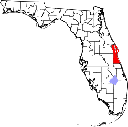 | |
| Towns | ||
| CDPs | ||
| Unincorporated communities | ||