Gerdau (river)
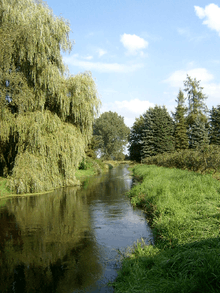 | |
| The Gerdau near Groß Süstedt | |
| Location | Counties of Celle and Uelzen; Lower Saxony (Germany) |
|---|---|
| Reference no. | DE: 5942 |
| Length | 29.71 km [1] |
| Source | In the Lüneburg Heath between Faßberg and Eimke 52°56′31″N 10°14′22″E / 52.9420139°N 10.239306°ECoordinates: 52°56′31″N 10°14′22″E / 52.9420139°N 10.239306°E |
| Source height | ca. 70 m above sea level (NHN) |
| Confluence | Near Veerßen (Uelzen) with the Stederau to become the Ilmenau 52°56′52″N 10°33′13″E / 52.947639°N 10.5536806°E |
| Mouth height | ca. 35 m above sea level (NHN) |
| Descent | ca. 35 m |
| Basin | Elbe |
| Progression | Ilmenau → Elbe → North Sea |
| Catchment | 427.74 km² [1] |
| Right tributaries | Häsebach, Hardau (for these and others see below) |
| Left tributaries | Schwienau (for these and others see below) |
| Large towns | Uelzen |
| Villages | Faßberg, Eimke, Gerdau |
| Hydrologically the main headstream of the Ilmenau | |
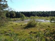
Brambostel Moor, the source region of the Gerdau
The Gerdau is a 30 km long, left (western) source river for the Ilmenau in the north German state of Lower Saxony.
The river rises in the eastern part of the Lüneburg Heath on the northeastern edge of the Südheide Nature Park. From its source, which is located in the Brambostel Moor Nature Reserve,[2] north of the 94 m high Faßberg, the Gerdau flows by the villages of Eimke and Gerdau towards Uelzen. South of Uelzen it merges with the Stederau to form the Ilmenau.
Tributaries
|
|
References
- 1 2 parameter error
- ↑ NSG Brambosteler Moor
This article is issued from Wikipedia - version of the 5/17/2016. The text is available under the Creative Commons Attribution/Share Alike but additional terms may apply for the media files.