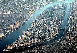
Gezira Island
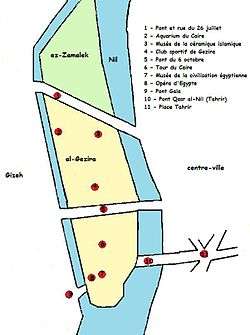
Map of Gezira Island.
Gezira Island is in the Nile River, in central Cairo, Egypt. The southern portion of the island contains the Gezira District, and the northern third contains the Zamalek District.
Gezira Island is west of downtown Cairo and Tahrir Square, connected across the Nile by three bridges each on the east and west sides, including the Qasr El Nil Bridge and 6th October Bridge. Under 19th century ruler Khedive Ismail the island was first called "Jardin des Plantes" (French for "Garden of Plants"), because of its great collection of exotic plants shipped from all over the world.[1]
Island landmarks
- Cairo Tower (1960), the tallest concrete construction in Egypt, built near the Gezira Sporting Club.[2]
- Egyptian Opera House (1988), built near the Cairo Tower, and one of the better performing arts venues in the Middle East.[3]
- El Sawy culturewheel Centre (2003), (Arabic: ساقية الصاوى) located beneath 15 May Bridge in Zamalek, one of the most important cultural venues in Egypt.[4]
- Gezira Sporting Club (1882), the oldest club in Egypt.[5]
Gallery
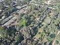 Gardens in El Gezira
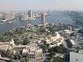 Southern Tip of Gezira Island
See also
References
| Wikimedia Commons has media related to Gezira Island. |
| Wikivoyage has a travel guide for Cairo/Gezira. |
- ↑ "Zamalek Today". e-dar.com. Retrieved 15 June 2010.
- ↑ Samir Raafat (16 August 1997). "The Cairo Tower". egy.com. Archived from the original on 15 June 2008. Retrieved 8 August 2008.
- ↑ "egypt hosts london's royal philharmonic orchestra for the first time in the region". Albawaba News. 30 January 2007. Retrieved 14 July 2014.
- ↑ "El Sawy Culturewheel in Egypt: From a place for beggars to a resort for intellectuals" (in Arabic). CNN. 2009-03-17. Retrieved 2009-04-01.
- ↑ Helmy, Heba. "Four clubs, four communities: The Gezira Sporting Club". egyptindependent.com. egyptindependent.com. Retrieved 5 February 2013.
Islands of Egypt | |
|---|---|
| Nile islands | |
| Red Sea islands | |
| Mediterranean Sea islands | |
Coordinates: 30°03′N 31°13′E / 30.050°N 31.217°E
This article is issued from Wikipedia - version of the 11/19/2016. The text is available under the Creative Commons Attribution/Share Alike but additional terms may apply for the media files.