Ghang Sukathokar
| Ghyang Sukathokar घ्याङ सुकाठोकर | |
|---|---|
| Village development committee | |
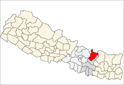
 Ghyang Sukathokar Location in Nepal | |
| Coordinates: 27°34′N 86°02′E / 27.56°N 86.04°ECoordinates: 27°34′N 86°02′E / 27.56°N 86.04°E | |
| Country |
|
| Zone | Janakpur Zone |
| District | Dolakha District |
| Population (1991) | |
| • Total | 4,600 |
| Time zone | Nepal Time (UTC+5:45) |
Ghyang Sukathokar is a village development committee in Dolakha District in the Janakpur Zone of north-eastern Nepal. At the time of the 1991 Nepal census it had a population of 4600.[1]
This VDC is surrounded by sailungeswor VDC in the north and south ,vedpu in the west and bytamakosi river in the east .This is religiously important place where the famous temples like Gaikhura mahadev ,Bhakure devi mandir are located ,along with many famous spots .
In this VDC people are mainly linked with agriculture and animal husbandry. Despite traditional occupation some people are ingaged in advanced and modern occupation like teaching ,office work etc.
References
- ↑ "Nepal Census 2001", Nepal's Village Development Committees, Digital Himalaya, retrieved 15 November 2009.
Kalinchwok sandes
External links
Headquarter: Bhimeshwar | ||
|  | |
"Loktantra sandes" local newspaper.
This article is issued from Wikipedia - version of the 8/24/2016. The text is available under the Creative Commons Attribution/Share Alike but additional terms may apply for the media files.