Glenferrie Road
| Glenferrie Road Victoria | |
|---|---|
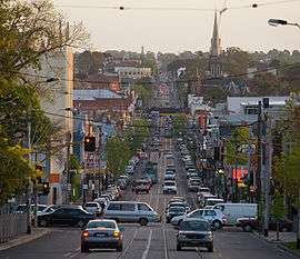 | |
| Glenferrie Road facing south, looking down the hill from Kew. Beyond the traffic lights is Hawthorn, in the foreground is Kew as Barkers Road forms the suburb boundaries. | |
| General information | |
| Type | Road |
| Length | 7 km (4.3 mi) |
| Route number(s) |
|
| Major junctions | |
| North end |
|
| |
| South end |
|
| Location(s) | |
| Major suburbs | Hawthorn, Kooyong |
| |
Glenferrie Road is a major north–south thoroughfare in Melbourne, Australia.
It runs from Kew to Malvern, and includes major shopping districts at both Hawthorn and Malvern.
Tram route 16 runs along the entire length of Glenferrie Road. Three railway stations – Glenferrie, Kooyong and Malvern – are each located at the intersections of their respective railway lines with Glenferrie Road.
The Kooyong Tennis Stadium, the original home of the Australian Open, is located on Glenferrie Road, as are Stonnington House, formerly the Toorak Campus of Deakin University (and Government House, Melbourne from 1901 to 1927) and the biggest campus of the Swinburne University of Technology.
See also
![]() Australian Roads portal
Australian Roads portal
External links
| Wikimedia Commons has media related to Glenferrie Road Festival. |
Coordinates: 37°49′35″S 145°2′5″E / 37.82639°S 145.03472°E