Godstone Rural District
| Godstone | |
|---|---|
 Modern successor (The six areas in the north-east corner shown were added on Godstone RD's abolition, one of which was newly created as as civil parish, Whyteleafe, from parts of Warlingham and Caterham) | |
| Area | |
| • 1911 | 49,907 acres (202.0 km2) |
| • 1961 | 52,506 acres (212.5 km2) |
| Population | |
| • 1901 | 18,378 |
| • 1971 | 43,381 |
| History | |
| • Created | 1894 |
| • Abolished | 1974 |
| • Succeeded by | Tandridge |
| Status | Rural district |
| • HQ | Godstone |
| Subdivisions | |
| • Type | Civil Parishes |
| • Units | See below |
Godstone Rural District was a rural district in Surrey, England from 1894 to 1974.
Geographic evolution
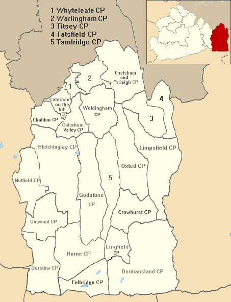
It contained the following civil parishes:[1]
- Addington (1915–1925) 14.6 square kilometres (5.6 sq mi) joined from Croydon RD then became component of Croydon (St John the Baptist) Civil Parish also officially known as Croydon within Croydon MB
- Bletchingley
- Most of Burstow (1933–1974) (joined from abolition of Reigate Rural District, 10 acres given to Horley)
- Caterham (1894–1899) (component of new Caterham Urban District then Caterham and Warlingham Urban District)
- Chelsham (1894–1969)
- Chaldon (1933-1974)
- Farleigh (1894–1933) 4.25 square kilometres (1.64 sq mi) (for following 36 years in Coulsdon and Purley Urban District)
- Chelsham and Farleigh (1969–1974)
- Crowhurst
- Felbridge
- Godstone
- Horne
- Limpsfield
- Lingfield
- Most of Nutfield (1933–1974) (216 acres given to Reigate MB)
- Oxted
- Tandridge
- Tatsfield
- Titsey
- Warlingham (1894–1929) (component of new Caterham and Warlingham Urban District)
- Woldingham (1894–1933) (component of new Caterham and Warlingham Urban District)
Successor
With the exception of Addington which was a temporary quite early addition, all of the above areas remained together and were combined with the Caterham and Warlingham Urban District to the north to create Tandridge District which is the easternmost part of Surrey.
References
This article is issued from Wikipedia - version of the 4/19/2015. The text is available under the Creative Commons Attribution/Share Alike but additional terms may apply for the media files.