Gogrial Airport
| Gogrial Airport | |||||||||||
|---|---|---|---|---|---|---|---|---|---|---|---|
| IATA: n/a – ICAO: HSGO | |||||||||||
| Summary | |||||||||||
| Airport type | Public, Civilian & Military | ||||||||||
| Owner | Civil Aviation Authority of South Sudan | ||||||||||
| Serves | Gogrial, South Sudan | ||||||||||
| Location |
Gogrial, | ||||||||||
| Elevation AMSL | 1,302 ft / 397 m | ||||||||||
| Coordinates | 08°32′24″N 28°06′00″E / 8.54000°N 28.10000°ECoordinates: 08°32′24″N 28°06′00″E / 8.54000°N 28.10000°E | ||||||||||
| Map | |||||||||||
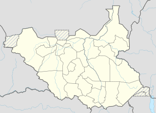 Gogrial Location of Gogrial Airport in South Sudan | |||||||||||
| Runways | |||||||||||
| |||||||||||
Gogrial Airport is an airport in South Sudan.
Location
Gogrial Airport (IATA: n/a, ICAO: HSGO) is located in Gogrial West County, Gogrial State, in the town of Gogrial, near the borders with the Republic of Sudan and the Abyei Region. The airport is located within the central business district of the town.
This location lies approximately 560 kilometres (350 mi), by air, northwest of Juba International Airport, the largest airport in South Sudan.[1] The geographic coordinates of this airport are: 8° 32' 24.00"N, 28° 06' 0.00"E (Latitude: 8.8670; Longitude: 28.1170). Gogrial Airport is situated 397 metres (1,302 ft) above sea level. The airport has a single unpaved runway, the dimensions of which are not publicly known at this time.
Overview
Gogrial Airport is a small civilian airport that serves the town of Gogrial and surrounding communities. There are no scheduled airline flights to Gogrial Airport at this time.
-
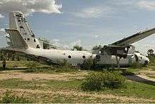
Sudan Air Force Antonov An-26-100 crash-landed in 1997 at the airstrip of Gogrial.