Golden Chersonese
The Golden Chersonese or Golden Peninsula (Ancient Greek: Χρυσῆ Χερσόνησος, Chrysḗ Chersónēsos; Latin: Chersonesus Aurea) was the name used for the Malay Peninsula by Greek and Roman geographers in classical antiquity, most famously in Ptolemy's 2nd-century Geography.
The Greek name is a calque of the Sanskrit Suvarnadvipa, where dvipa might refer to either a peninsula or an island. Eratosthenes, Dionysius Periegetes, and Pomponius Mela understood it as the Golden Island[1], referring to modern-day Sumatra while excluding the Malay Peninsula; Ptolemy followed Marinus of Tyre in describing it as a peninsula, without including Sumatra.[2][3][4]
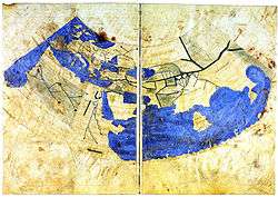
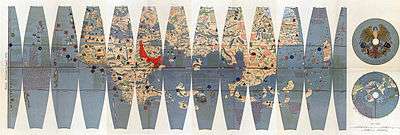
After Hipparchus's 3-volume work against Eratosthenes, most classical geographers—including Marinus and Ptolemy—held that the Indian Ocean was a closed sea. Ptolemy placed the Great Gulf east of the Golden Peninsula but then closed it in the far east with a border of unknown lands. Josephus speaks of a land in the area called "Aurea", which he equates with the Biblical Ophir, whence the ships of Tyre and Israel brought back gold and other trade items.
By the 8th century, Arab geographers were well aware that this was mistaken. Instead, following al-Khwārizmī's Book of the Description of the Earth, they showed a narrow or larger connection between the Indian and World Oceans and placed the eastern limit of the inhabited world at the Island of the Jewel in the Sea of Darkness beyond the Malay Peninsula. The Ptolemaic eastern shore became the Dragon's Tail peninsula.
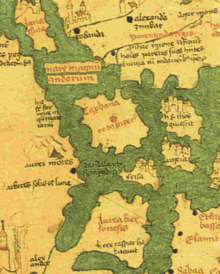
The Golden Chersonese is shown on the mappemonde of Andreas Walsperger, made in Constance around 1448, bearing the inscription, hic rex caspar habitavit (here lived King Caspar). Caspar was one of the Three Magi who worshipped the newborn Christ at Bethlehem.
Martin of Bohemia, on his 1492 geographical globe, located the islands of Chryse and Argyre ("Gold" and "Silver") in the vicinity of Zipangu (Japan), which was accorded to be "rich in gold" by Marco Polo. An expedition was sent to find the purported islands in this location under the command of Pedro de Unamunu in 1587.[5][6]
See also
References
- ↑ Also partially translated in forms such as the Isle of Chryse, Chryse Island, &c.
- ↑ G. E. Gerini, Researches on Ptolemy's geography of Eastern Asia (further India and Indo-Malay archipelago), London, Royal Asiatic Society, Asiatic Society Monographs, vol.1, 1909, pp.77-111.
- ↑ H. Kern, "Java en het Goudeiland Volgens de Oudste Berichten", Bijdragen tot de Taal-, Land- en Volkenkunde van Nederlandsch-Indië, Volume 16, 1869, pp.638-648.
- ↑ Udai Prakash Arora, “Greek Geographers on the Indian Ocean and Southeast Asia”, in Chattopadhyaya, D. P. and Project of History of Indian Science, Philosophy, and Culture (eds.), History of Science, Philosophy and Culture in Indian Civilization, New Delhi, Oxford University Press, 1999, Vol.1, Pt.3, C.G. Pande (ed.), India's Interaction with Southeast Asia, Chapter 6, pp.184-185.
- ↑ The Travels of Pedro Teixeira, tr. and annotated by W.F. Sinclair, London, Hakluyt Society, Series 2, Vol.9, 1902, p.10.
- ↑ E.W. Dahlgren, “Were the Hawaiian Islands visited by the Spaniards before their Discovery by Captain Cook in 1778?”, Kungliga Svenska Vetenskapsakademiens Handlingar, Band 57. No.1, 1916-1917, pp.1-222, pp.47-48, 66.