Goleigh Hill
| Goleigh Hill | |
|---|---|
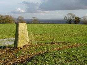 Trig point on the hill above Goleigh Farm | |
| Highest point | |
| Elevation | 220 m (720 ft) [1] |
| Prominence | 53 m (174 ft) [1] |
| Parent peak | Butser Hill [1] |
| Coordinates | 51°04′20″N 0°57′50″W / 51.0723°N 0.9638°WCoordinates: 51°04′20″N 0°57′50″W / 51.0723°N 0.9638°W |
| Geography | |
| Location | Hampshire, England |
| Parent range | Hampshire Downs |
| OS grid | SU726308 |
| Topo map | OS Landranger |
Goleigh Hill is one of the highest points in the county of Hampshire, England. It is part of the Hampshire Downs and reaches a height of 220 metres (720 ft) above sea level.
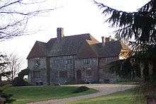
Goleigh Manor
Goleigh Hill rises about 2.5 kilometres west of the village of Empshott in Hampshire and is one of the East Hampshire Hangers. The top of the hill is open. Wooded areas on its flanks included Goleigh and Lye Woods to the west and Abbot's Copse to the east. Goleigh Farm lies on the northwestern slope of the hill with Goleigh Manor in the valley below it. There is a trig point at the summit.[2]
References
- 1 2 3 Summit Listings by Relative Height by Mark Jackson, compiled by Jonathan de Ferranti. Accessed on 15 May 2013.
- ↑ Ordnance Survey 1:50,000 Landranger series.
This article is issued from Wikipedia - version of the 7/11/2013. The text is available under the Creative Commons Attribution/Share Alike but additional terms may apply for the media files.