Gore Bay-Manitoulin Airport
| Gore Bay-Manitoulin Airport | |||||||||||||||
|---|---|---|---|---|---|---|---|---|---|---|---|---|---|---|---|
 | |||||||||||||||
|
IATA: YZE – ICAO: CYZE – WMO: 71956 | |||||||||||||||
| Summary | |||||||||||||||
| Airport type | Public | ||||||||||||||
| Operator | Gore Bay-Manitoulin Airport Commission | ||||||||||||||
| Serves | Gore Bay, Ontario | ||||||||||||||
| Location | Gordon/Barrie Island, Ontario | ||||||||||||||
| Time zone | EST (UTC−05:00) | ||||||||||||||
| • Summer (DST) | EDT (UTC−04:00) | ||||||||||||||
| Elevation AMSL | 623 ft / 190 m | ||||||||||||||
| Coordinates | 45°53′03″N 082°34′06″W / 45.88417°N 82.56833°WCoordinates: 45°53′03″N 082°34′06″W / 45.88417°N 82.56833°W | ||||||||||||||
| Map | |||||||||||||||
 CYZE Location in Ontario | |||||||||||||||
| Runways | |||||||||||||||
| |||||||||||||||
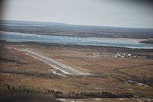
Gore Bay-Manitoulin Airport, looking northwest
Gore Bay-Manitoulin Airport, (IATA: YZE, ICAO: CYZE), is located 5 nautical miles (9.3 km; 5.8 mi) west southwest of Gore Bay, in the township of Gordon/Barrie Island, Ontario, Canada.
The airport is classified as an airport of entry by Nav Canada and is staffed by the Canada Border Services Agency (CBSA). CBSA officers at this airport can handle general aviation aircraft only, with no more than 15 passengers.[1]
References
- 1 2 Canada Flight Supplement. Effective 0901Z 15 September 2016 to 0901Z 10 November 2016
- ↑ Synoptic/Metstat Station Information
External links
- Past three hours METARs, SPECI and current TAFs for Gore Bay-Manitoulin Airport from Nav Canada as available.
| By name | |
|---|---|
| By location indicator | |
| By province/territory | |
| By region | |
| National Airports System | |
| Related | |
| |
This article is issued from Wikipedia - version of the 12/4/2016. The text is available under the Creative Commons Attribution/Share Alike but additional terms may apply for the media files.