Gourdan-Polignan
| Gourdan-Polignan | ||
|---|---|---|
|
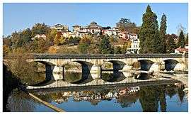
The Pont de Gourdan | ||
| ||
 Gourdan-Polignan | ||
|
Location within Occitanie region  Gourdan-Polignan | ||
| Coordinates: 43°04′18″N 0°34′28″E / 43.0717°N 0.5744°ECoordinates: 43°04′18″N 0°34′28″E / 43.0717°N 0.5744°E | ||
| Country | France | |
| Region | Occitanie | |
| Department | Haute-Garonne | |
| Arrondissement | Saint-Gaudens | |
| Canton | Barbazan | |
| Intercommunality | Haut-Comminges | |
| Government | ||
| • Mayor (2008–2014) | Serge Launay | |
| Area1 | 5.26 km2 (2.03 sq mi) | |
| Population (2008)2 | 1,344 | |
| • Density | 260/km2 (660/sq mi) | |
| Time zone | CET (UTC+1) | |
| • Summer (DST) | CEST (UTC+2) | |
| INSEE/Postal code | 31224 / 31210 | |
| Elevation |
411–635 m (1,348–2,083 ft) (avg. 434 m or 1,424 ft) | |
|
1 French Land Register data, which excludes lakes, ponds, glaciers > 1 km² (0.386 sq mi or 247 acres) and river estuaries. 2 Population without double counting: residents of multiple communes (e.g., students and military personnel) only counted once. | ||

Gourdan-Polignan is a commune in the Haute-Garonne department in southwestern France.
Population
| Historical population | ||
|---|---|---|
| Year | Pop. | ±% |
| 1962 | 1,531 | — |
| 1968 | 1,664 | +8.7% |
| 1975 | 1,656 | −0.5% |
| 1982 | 1,394 | −15.8% |
| 1990 | 1,221 | −12.4% |
| 1999 | 1,194 | −2.2% |
| 2008 | 1,344 | +12.6% |
See also
References
| Wikimedia Commons has media related to Gourdan-Polignan. |
This article is issued from Wikipedia - version of the 7/12/2014. The text is available under the Creative Commons Attribution/Share Alike but additional terms may apply for the media files.