Gov. Thomas Hutchinson's Ha-ha
|
Gov. Thomas Hutchinson's Ha-ha | |
 | |
  | |
| Location | 100-122 Randolph Ave., Milton, Massachusetts |
|---|---|
| Coordinates | 42°15′55″N 71°4′4″W / 42.26528°N 71.06778°WCoordinates: 42°15′55″N 71°4′4″W / 42.26528°N 71.06778°W |
| Area | less than one acre |
| Built | 1771 |
| Part of | Milton Hill Historic District (#95000698) |
| NRHP Reference # | 75000290[1] |
| Significant dates | |
| Added to NRHP | February 13, 1975 |
| Designated CP | June 9, 1995 |
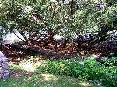
Gov. Thomas Hutchinson's Ha-ha is a historic ha-ha at 100-122 Randolph Avenue in Milton, Massachusetts.
The ha-ha (a sunken wall which permits unblocked views, while still serving functions of a wall such as delineating a border and preventing livestock from crossing) was constructed by then-Acting Governor Thomas Hutchinson in the early 1700s, when the land was part of his extensive Milton estate.[2] It was added to the National Register of Historic Places in 1975, and is a contributing property to the Milton Hill Historic District.[2]
The ha-ha, which is of modest size, is now on the grounds of St. Michael's Church at 100 Randolph Avenue, approximately one block from Governor Hutchinson's Field, a property of The Trustees of Reservations. Park on the street and walk in the driveway to the left (north) of the church. The ha-ha, with a descriptive sign, is on the right before the bend of the driveway.
See also
References
- ↑ National Park Service (2009-03-13). "National Register Information System". National Register of Historic Places. National Park Service.
- 1 2 "MACRIS inventory record for Gov. Thomas Hutchinson's Ha-ha". Commonwealth of Massachusetts. Retrieved 2014-05-24.
| Topics |  | ||||||||||||||||||||||||||||||
|---|---|---|---|---|---|---|---|---|---|---|---|---|---|---|---|---|---|---|---|---|---|---|---|---|---|---|---|---|---|---|---|
| Lists by county | |||||||||||||||||||||||||||||||
| Lists by city |
| ||||||||||||||||||||||||||||||
| Other lists | |||||||||||||||||||||||||||||||
| |||||||||||||||||||||||||||||||