Grade II* listed buildings in Eastleigh (borough)
There are over 20,000 Grade II* listed buildings in England. This page is a list of these buildings in the district of Eastleigh in Hampshire.
Eastleigh
| Name | Location | Type | Completed [note 1] | Date designated | Grid ref.[note 2] Geo-coordinates |
Entry number [note 3] | Image |
|---|---|---|---|---|---|---|---|
| (old) Church of St Bartholomew | Botley, Eastleigh | Church | 13th century | 5 December 1955 | SU5104511954 50°54′17″N 1°16′32″W / 50.90481°N 1.275421°W |
1322638 |  |
| Bursledon Windmill | Bursledon, Eastleigh | Post Mill | 1741 | 14 February 1983 | SU4827010829 50°53′42″N 1°18′54″W / 50.894932°N 1.315031°W |
1281479 | 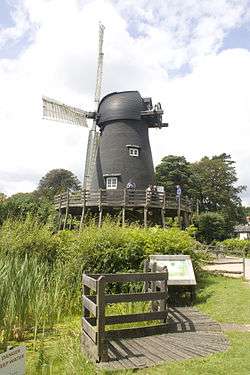 |
| Church of St Leonard | Bursledon, Eastleigh | Church | 13th century | 5 December 1955 | SU4886109717 50°53′06″N 1°18′24″W / 50.884884°N 1.306777°W |
1111964 |  |
| Church of St Andrew | Hamble-le-Rice, Eastleigh | Church | 12th century | 5 December 1955 | SU4810106737 50°51′29″N 1°19′05″W / 50.858152°N 1.317971°W |
1111917 |  |
| Sydney Lodge including stable | Hamble-le-Rice, Eastleigh | House | 1789-1798 | 5 December 1955 | SU4705107250 50°51′46″N 1°19′58″W / 50.862851°N 1.332822°W |
1111924 | 
|
| Chapel in the Grounds of the Royal Victoria Hospital | Royal Victoria Hospital, Hound, Eastleigh | Chapel | 1856-63 | 9 April 1974 | SU4643407664 50°52′00″N 1°20′30″W / 50.866623°N 1.341536°W |
1322694 |  |
| Church of St Mary | Hound, Eastleigh | Church | 13th century | 5 December 1955 | SU4708308735 50°52′34″N 1°19′56″W / 50.876201°N 1.332177°W |
1322693 |  |
| Netley Castle | Hound, Eastleigh | Castle | 1840-1860 | 21 October 1974 | SU4511308862 50°52′39″N 1°21′37″W / 50.8775°N 1.360159°W |
1336957 | 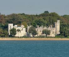 |
| Church of St Nicholas | North Stoneham, Eastleigh | Church | Medieval | 14 August 1953 | SU4405617308 50°57′13″N 1°22′27″W / 50.953526°N 1.374164°W |
1204006 |  |
Notes
- ↑ The date given is the date used by Historic England as significant for the initial building or that of an important part in the structure's description.
- ↑ Sometimes known as OSGB36, the grid reference is based on the British national grid reference system used by the Ordnance Survey.
- ↑ The "List Entry Number" is a unique number assigned to each listed building and scheduled monument by Historic England.
External links
![]() Media related to Grade II* listed buildings in Hampshire at Wikimedia Commons
Media related to Grade II* listed buildings in Hampshire at Wikimedia Commons
This article is issued from Wikipedia - version of the 11/8/2016. The text is available under the Creative Commons Attribution/Share Alike but additional terms may apply for the media files.