Grade II* listed buildings in Fareham (borough)
There are over 20,000 Grade II* listed buildings in England. This page is a list of these buildings in the district of Fareham in Hampshire.
Fareham
| Name | Location | Type | Completed [note 1] | Date designated | Grid ref.[note 2] Geo-coordinates |
Entry number [note 3] | Image |
|---|---|---|---|---|---|---|---|
| Bishopwood | Fareham, Borough of Fareham | Cottage Ornee | Early 19th century | 18 October 1955 | SU5670606126 50°51′07″N 1°11′45″W / 50.85188°N 1.195822°W |
1093540 | 
|
| Brick Kiln, Chimney, Drying Sheds, Boiler and Engine House at Bursledon Brickworks South Section | Lower Swanwick | Brick Kiln | 1897 | 30 January 1981 | SU5000409819 50°53′09″N 1°17′26″W / 50.885703°N 1.290516°W |
1233725 |
|
| Brooklands | Sarisbury | House | c1800 (pre 1807) | 22 October 1976 | SU4964408963 50°52′41″N 1°17′45″W / 50.878037°N 1.295749°W |
1093503 |
|
| Cams Hall | Fareham | Country House | Late 17th century | 18 October 1955 | SU5893605738 50°50′53″N 1°09′51″W / 50.848169°N 1.164209°W |
1232890 | 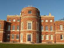 |
| Church of the Holy Trinity | Fareham | Church | 1834-7 | 18 October 1955 | SU5758106176 50°51′08″N 1°11′00″W / 50.852243°N 1.183385°W |
1276622 |  |
| Crofton Old Church (St Edmund's) | Crofton | Chapel of Ease | 13th-century origins | 18 October 1955 | SU5510804183 50°50′04″N 1°13′08″W / 50.834563°N 1.218812°W |
1233279 |  |
| Dean Farmhouse | Fareham | Timber Framed House | 16th century | 22 October 1976 | SU5738808211 50°52′14″N 1°11′09″W / 50.87056°N 1.185808°W |
1233656 |
|
| Fareham and County Club | Fareham | House | 18th century | 18 October 1955 | SU5827706324 50°51′13″N 1°10′25″W / 50.853504°N 1.173475°W |
1094245 |
|
| Great Posbrook | Titchfield | House | 19th century | 18 October 1955 | SU5359205033 50°50′32″N 1°14′25″W / 50.842348°N 1.240213°W |
1233024 |
|
| Kintyre House | Fareham | House | 18th century | 18 October 1955 | SU5826806273 50°51′11″N 1°10′25″W / 50.853047°N 1.173611°W |
1338894 |
|
| Parish Church of St Peter and St Paul | Fareham | Parish Church | Medieval | 18 October 1955 | SU5817506502 50°51′18″N 1°10′30″W / 50.855115°N 1.174896°W |
1094332 |  |
| Southern Barn at Great Posbrook Farm | Titchfield | Aisled Barn | Late Medieval | 22 October 1976 | SU5353404978 50°50′31″N 1°14′28″W / 50.841859°N 1.241045°W |
1233029 |
|
| The Old Manor House | Fareham | House | 18th century | 22 October 1976 | SU5818506667 50°51′24″N 1°10′29″W / 50.856598°N 1.174728°W |
1233542 |
|
| Tudor Wing, West Wing and Georgian House, St Margarets Priory | Titchfield | House | From 16th century | 18 October 1955 | SU5342106114 50°51′08″N 1°14′33″W / 50.852084°N 1.242485°W |
1276854 |
|
| 28–30 South Street | Titchfield | House | Late 15th century to early 16th century | 18 October 1955 | SU5398505696 50°50′54″N 1°14′04″W / 50.848273°N 1.234535°W |
1276734 |
|
| 69 High Street | Fareham | House | Older | 18 October 1955 | SU5827206306 50°51′12″N 1°10′25″W / 50.853343°N 1.173549°W |
1094246 |
|
| 7 High Street | Fareham | House | 18th century | 18 October 1955 | SU5822606261 50°51′11″N 1°10′27″W / 50.852943°N 1.17421°W |
1094272 |
|
| 12 High Street | Fareham | House | Late 18th century | 18 October 1955 | SU5823706309 50°51′12″N 1°10′27″W / 50.853374°N 1.174046°W |
1094273 |
|
| 13–17 High Street | Fareham | House | 18th century | 18 October 1955 | SU5824106325 50°51′13″N 1°10′26″W / 50.853517°N 1.173987°W |
1351273 | |
Notes
- ↑ The date given is the date used by Historic England as significant for the initial building or that of an important part in the structure's description.
- ↑ Sometimes known as OSGB36, the grid reference is based on the British national grid reference system used by the Ordnance Survey.
- ↑ The "List Entry Number" is a unique number assigned to each listed building and scheduled monument by Historic England.
External links
![]() Media related to Grade II* listed buildings in Hampshire at Wikimedia Commons
Media related to Grade II* listed buildings in Hampshire at Wikimedia Commons
This article is issued from Wikipedia - version of the 11/8/2016. The text is available under the Creative Commons Attribution/Share Alike but additional terms may apply for the media files.