Grade II* listed buildings in Hart
There are over 20,000 Grade II* listed buildings in England. This page is a list of these buildings in the district of Hart in Hampshire.
Hart
| Name | Location | Type | Completed [note 1] | Date designated | Grid ref.[note 2] Geo-coordinates |
Entry number [note 3] | Image |
|---|---|---|---|---|---|---|---|
| Minley Manor | Blackwater and Hawley, Hart | House | 1858-1860 | 26 June 1987 | SU8222758001 51°18′55″N 0°49′18″W / 51.315188°N 0.821558°W |
1258061 |  |
| Moor Place Farm House | Bramshill, Hart | Farmhouse | 16th century | 8 July 1952 | SU7530060743 51°20′27″N 0°55′13″W / 51.340796°N 0.920351°W |
1340031 | 
|
| Christ Church | Church Crookham, Hart | Meeting Hall | 1971 | 19 May 1993 | SU8077951804 51°15′35″N 0°50′37″W / 51.259684°N 0.84373°W |
1244780 |  |
| Firgrove House | Eversley, Hart | House | Early 18th century | 8 July 1952 | SU7993760689 51°20′23″N 0°51′14″W / 51.339679°N 0.853807°W |
1092336 | 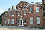 |
| The Old Rectory | Eversley, Hart | House | 18th century | 8 July 1952 | SU7790260880 51°20′30″N 0°52′59″W / 51.341678°N 0.882973°W |
1092335 | 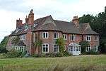 |
| Church of All Saints | Fleet, Hart | Church | 1862 | 26 June 1987 | SU8080854507 51°17′02″N 0°50′34″W / 51.28398°N 0.842704°W |
1339861 | 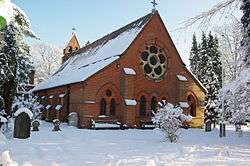 |
| Church Cottage | Greywell, Hart | House | 16th century | 8 July 1952 | SU7172151049 51°15′15″N 0°58′25″W / 51.254106°N 0.973668°W |
1339865 |
|
| Church of St Mary the Virgin | Greywell, Hart | Church | Norman | 24 November 1961 | SU7184150972 51°15′12″N 0°58′19″W / 51.253399°N 0.971965°W |
1117033 |  |
| Barn and attached Outbuildings at Lodge Farm to North West of Farmhouse | Elvetham Park, Hartley Wintney, Hart | House | Mid 19th century | 26 June 1987 | SU7801256273 51°18′01″N 0°52′57″W / 51.300246°N 0.882401°W |
1092287 |
|
| Church of St Mary | Hartley Wintney, Hart | Church | Medieval | 24 November 1961 | SU7677855872 51°17′49″N 0°54′01″W / 51.296808°N 0.900184°W |
1092270 | 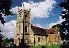 |
| Elvetham Hall House | Elvetham Park, Hartley Wintney, Hart | House | 1859-1862 | 19 July 1973 | SU7819456389 51°18′05″N 0°52′47″W / 51.301264°N 0.879766°W |
1092322 |  |
| Four Acre House | Hartley Wintney, Hart | House | 1901 | 26 June 1987 | SU7520356342 51°18′04″N 0°55′22″W / 51.301244°N 0.922671°W |
1339875 |  |
| The Barn | Phoenix Green, Hartley Wintney, Hart | House | c. 1903 | 14 October 1986 | SU7581555800 51°17′47″N 0°54′50″W / 51.29629°N 0.914009°W |
1242682 |
|
| West Green House | West Green, Hartley Wintney, Hart | Country House | Early 18th century | 8 July 1952 | SU7455456360 51°18′05″N 0°55′55″W / 51.301491°N 0.931974°W |
1242807 | 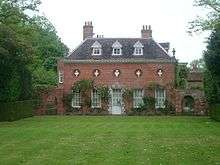 |
| Wintney Farm Barn to West of Farmhouse | Hartley Wintney, Hart | Wall | founded 1190 | 8 July 1952 | SU7763655218 51°17′27″N 0°53′17″W / 51.290813°N 0.888023°W |
1092276 |
|
| Church of St Michael | Heckfield, Hart | Church | Medieval | 24 November 1961 | SU7226260501 51°20′20″N 0°57′50″W / 51.339015°N 0.964007°W |
1092243 |  |
| Highfield House | Heckfield, Hart | House | Early 18th century | 8 July 1952 | SU7221360451 51°20′19″N 0°57′53″W / 51.338571°N 0.96472°W |
1258374 |
|
| Borough Court | Hook, Hart | House | 16th century | 26 June 1987 | SU7380355905 51°17′51″N 0°56′34″W / 51.297498°N 0.942839°W |
1339893 |
|
| Barn at Summers Farm to East of Farmhouse | Long Sutton, Hart | Cruck Barn | 1441-2 | 26 June 1987 | SU7515947024 51°13′03″N 0°55′31″W / 51.217478°N 0.925256°W |
1339897 |
|
| Church of All Saints | Long Sutton, Hart | Church | 13th century | 24 November 1961 | SU7388947381 51°13′15″N 0°56′36″W / 51.220853°N 0.943363°W |
1092232 | 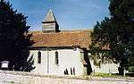 |
| Long Sutton Manor | Long Sutton, Hart | House | 17th century | 26 June 1987 | SU7382647451 51°13′17″N 0°56′39″W / 51.221491°N 0.944251°W |
1258941 |
|
| The Old Parsonage | Long Sutton, Hart | House | 17th century | 8 July 1952 | SU7393547384 51°13′15″N 0°56′34″W / 51.220874°N 0.942704°W |
1339896 |
|
| Hazeley Heath Cottage | Hazeley Heath, Mattingley, Hart | House | 1898 | 26 June 1987 | SU7473258417 51°19′12″N 0°55′44″W / 51.31996°N 0.928991°W |
1243551 |
|
| Almshouses | Odiham, Hart | Almshouses | 1628 | 8 July 1952 | SU7406050854 51°15′07″N 0°56′25″W / 51.252055°N 0.940198°W |
1092192 |
|
| King's Barn | Odiham, Hart | House | c. 1780 | 8 July 1952 | SU7393451018 51°15′13″N 0°56′31″W / 51.253545°N 0.94197°W |
1244231 |
|
| Lodge Farmhouse | Odiham, Hart | Farmhouse | 15th century | 8 July 1952 | SU7364352567 51°16′03″N 0°56′45″W / 51.267509°N 0.94582°W |
1092163 |
|
| Mary Court, including attached Gate Pier | Odiham, Hart | House | Early 18th century | 8 July 1952 | SU7422251096 51°15′15″N 0°56′16″W / 51.254209°N 0.937827°W |
1244132 |
|
| The George Hotel | Odiham, Hart | Steps | 16th century | 8 July 1952 | SU7405151088 51°15′15″N 0°56′25″W / 51.25416°N 0.940279°W |
1092149 |  |
| The Old House (48, High St) | Odiham, Hart | House | Late 18th century | 8 July 1952 | SU7421051125 51°15′16″N 0°56′17″W / 51.254472°N 0.937993°W |
1339905 |  |
| The Priory | Odiham, Hart | House | 16th century | 8 July 1952 | SU7379551057 51°15′14″N 0°56′38″W / 51.253914°N 0.943953°W |
1092156 |  |
| The White House | Odiham, Hart | House | 1812 | 8 July 1952 | SU7424251142 51°15′17″N 0°56′15″W / 51.25462°N 0.937531°W |
1092174 |
|
| Archway at southern End of Laundry Court, leading to rear of Kitchen Gardens, and Garden House attached to south | Rotherwick, Hart | Wall | 1901-1904 | 26 June 1987 | SU7101355140 51°17′28″N 0°58′59″W / 51.290974°N 0.983°W |
1272254 |  |
| Rotherwick Church | Rotherwick, Hart | Church | 13th century | 24 November 1961 | SU7117356263 51°18′04″N 0°58′50″W / 51.301051°N 0.980483°W |
1244570 | 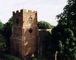 |
| Main and Subsidiary Blocks at Tylney Hall | Rotherwick, Hart | Country house | 1879 | 16 March 1984 | SU7095055245 51°17′31″N 0°59′02″W / 51.291926°N 0.983883°W |
1244655 |  |
| North Terrace with Sunken Garden and Pavilion | Rotherwick, Hart | Balustrade | c. 1900 | 16 March 1984 | SU7092055277 51°17′32″N 0°59′04″W / 51.292218°N 0.984307°W |
1244657 |
|
| Walled Gardens, Cottages, Greenhouses and Tower to South West of Tylney Hall | Rotherwick, Hart | House | 1899-1904 | 16 March 1984 | SU7088755129 51°17′27″N 0°59′05″W / 51.290891°N 0.984809°W |
1244656 |
|
| Blounce Farmhouse | South Warnborough, Hart | Farmhouse | dated 1699 | 8 July 1952 | SU7126845320 51°12′10″N 0°58′53″W / 51.202657°N 0.981296°W |
1272245 |
|
| Church of St Andrew | South Warnborough, Hart | Church | 13th century | 24 November 1961 | SU7215747192 51°13′10″N 0°58′06″W / 51.219375°N 0.968198°W |
1244695 |  |
| Winchfield House | Winchfield House, Winchfield, Hart | Country House | Late 18th century | 8 July 1952 | SU7612555117 51°17′24″N 0°54′35″W / 51.290108°N 0.909709°W |
1244740 |
|
| Yateley Hall | Yateley, Hart | House | Early 18th century | 8 July 1952 | SU8140860511 51°20′16″N 0°49′58″W / 51.33787°N 0.832734°W |
1272233 | 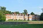 |
Notes
- ↑ The date given is the date used by Historic England as significant for the initial building or that of an important part in the structure's description.
- ↑ Sometimes known as OSGB36, the grid reference is based on the British national grid reference system used by the Ordnance Survey.
- ↑ The "List Entry Number" is a unique number assigned to each listed building and scheduled monument by Historic England.
External links
![]() Media related to Grade II* listed buildings in Hampshire at Wikimedia Commons
Media related to Grade II* listed buildings in Hampshire at Wikimedia Commons
This article is issued from Wikipedia - version of the 11/8/2016. The text is available under the Creative Commons Attribution/Share Alike but additional terms may apply for the media files.