Grade II* listed buildings in North Devon
There are over 20,000 Grade II* listed buildings in England. This page is a list of these buildings in the district of North Devon in Devon.
North Devon
| Name | Location | Type | Completed [note 1] | Date designated | Grid ref.[note 2] Geo-coordinates |
Entry number [note 3] | Image |
|---|---|---|---|---|---|---|---|
| Arlington Court | Arlington | Country House | 1820 | 25 February 1965 | SS6109440522 51°08′49″N 3°59′14″W / 51.147057°N 3.987265°W |
1106817 | .jpg) |
| Church of St James | Arlington | Church | Late 15th century or early 16th century | 25 February 1965 | SS6129540480 51°08′48″N 3°59′04″W / 51.146728°N 3.984377°W |
1106820 |  |
| Glebe House | Arlington | House | 1965 | 25 February 1965 | SS6132640542 51°08′50″N 3°59′02″W / 51.147293°N 3.983958°W |
1106823 | 
|
| Church of St Peter | Ashford | Parish Church | Medieval | 25 February 1965 | SS5335035357 51°05′55″N 4°05′45″W / 51.098711°N 4.095798°W |
1107140 | 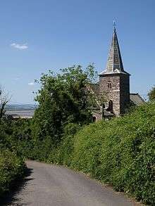 |
| Lemons Farmhouse | Atherington | Farmhouse | Late 15th century | 25 February 1965 | SS5920923082 50°59′24″N 4°00′27″W / 50.98987°N 4.007402°W |
1106856 |
|
| Church of Holy Trinity and attached Railings and Gate | Barnstaple | Gate | 1843-1845 | 22 June 1981 | SS5620632778 51°04′35″N 4°03′14″W / 51.076259°N 4.054011°W |
1384982 | .jpg) |
| Church of Saints Peter and Paul & Church of St Peter including the Doddridge Library | Barnstaple | Churches | 1667 | 19 January 1951 | SS5583333223 51°04′49″N 4°03′34″W / 51.080165°N 4.059509°W |
1385251 | 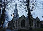 |
| Horwoods Almshouses | Barnstaple | Almshouses | 1674 | 19 January 1951 | SS5587233171 51°04′47″N 4°03′32″W / 51.079707°N 4.058932°W |
1385102 |  |
| North Country Inn | Barnstaple | Courtyard House | 17th century | 31 December 1973 | SS5572033508 51°04′58″N 4°03′40″W / 51.082697°N 4.061235°W |
1385068 |
|
| Old School Coffee House (formerly Horwoods School) | Barnstaple | Restaurant | 1999 | 19 January 1951 | SS5586233151 51°04′46″N 4°03′33″W / 51.079525°N 4.059067°W |
1385105 |
|
| Paiges Almshouses | Barnstaple | Almshouses | 1656 | 19 January 1951 | SS5586133181 51°04′47″N 4°03′33″W / 51.079794°N 4.059093°W |
1385106 |  |
| Pill House | Bishop's Tawton/Rumsam, Barnstaple | Apartment | 1951 | 19 January 1951 | SS5629331617 51°03′57″N 4°03′08″W / 51.065848°N 4.052308°W |
1385256 |
|
| The Guildhall | Barnstaple | Guildhall | 1826 | 19 January 1951 | SS5579133247 51°04′49″N 4°03′36″W / 51.08037°N 4.060118°W |
1385188 | 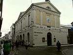 |
| Three Tuns Inn | Barnstaple | Jettied House | Renovated 1946 | 19 January 1951 | SS5576933243 51°04′49″N 4°03′38″W / 51.080328°N 4.06043°W |
1385165 |
|
| 8 Cross Street | Barnstaple | House | c. 1635 | 19 January 1951 | SS5573333177 51°04′47″N 4°03′39″W / 51.079726°N 4.060917°W |
1385114 |
|
| 39 High Street | Barnstaple | House | Wing extended 19th century | 31 December 1973 | SS5575933343 51°04′52″N 4°03′38″W / 51.081224°N 4.060613°W |
1385154 |
|
| 36 Pilton Street | Pilton, Barnstaple | House | Refurbished early 18th century | 19 January 1951 | SS5567334060 51°05′16″N 4°03′44″W / 51.087646°N 4.062126°W |
1385277 |
|
| Church of St Peter | Berrynarbor | Church | 1767 | 25 February 1965 | SS5604346709 51°12′05″N 4°03′43″W / 51.201405°N 4.061908°W |
1306896 | .jpg) |
| Watermouth Castle, including Front Retaining Wall and Rear Courtyard Walls | Berrynarbor | Country House | 1825-26 | 9 March 1953 | SS5557648041 51°12′48″N 4°04′09″W / 51.213257°N 4.069124°W |
1168686 | 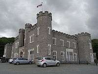 |
| Cross Farmhouse | Bishop's Nympton | Farmhouse | Late medieval origins | 20 February 1967 | SS7460623635 50°59′54″N 3°47′18″W / 50.998404°N 3.788334°W |
1107288 |
|
| Barn and Horse Engine House approximately 5 Metres East of Wellesley Farmhouse | Bishop's Tawton | Cruck House | 19th century | 18 March 1986 | SS5998926745 51°01′23″N 3°59′52″W / 51.022979°N 3.99771°W |
1164044 |
|
| Great Halmpstone | Bishop's Tawton | Farmhouse | 15th century | 18 March 1986 | SS5943228354 51°02′14″N 4°00′23″W / 51.037303°N 4.006271°W |
1107722 |
|
| Hall House | Hall, Bishop's Tawton | Country House | 1846-1850 | 26 February 1965 | SS5855727168 51°01′35″N 4°01′06″W / 51.02643°N 4.018279°W |
1107730 |  |
| Orangery approximately 50 Metres South West of Hall House | Hall, Bishop's Tawton | Orangery | 18th century | 25 February 1965 | SS5842827116 51°01′33″N 4°01′12″W / 51.025931°N 4.020097°W |
1366225 |
|
| Rosehill | Bishop's Tawton | House | c. 1835 | 18 March 1986 | SS5709631439 51°03′52″N 4°02′27″W / 51.064449°N 4.040785°W |
1107696 |
|
| Ash Barton Estate | Braunton | Estate | 17th century | 25 February 1965 | SS5112537326 51°06′57″N 4°07′42″W / 51.115831°N 4.128365°W |
1107105 | 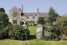 |
| Broadgate | Braunton | House | C20 | 9 March 1953 | SS4891636866 51°06′40″N 4°09′35″W / 51.111119°N 4.159708°W |
1107084 |
|
| Buckland Manor | Braunton | Manor House | Early 17th century | 25 February 1965 | SS4837837743 51°07′08″N 4°10′04″W / 51.118857°N 4.167757°W |
1107112 | .jpg) |
| Church House | Braunton | Church House | 16th century | 25 February 1965 | SS4894637052 51°06′46″N 4°09′34″W / 51.112798°N 4.159358°W |
1161569 |
|
| Fairlinch | Braunton | Farmhouse | 1629 | 25 February 1965 | SS4751237563 51°07′01″N 4°10′48″W / 51.11701°N 4.180045°W |
1325553 |
|
| Saunton Court including Garden Structures to East Incorporating Gateway, Garden Walls and Gatepiers, Gazebo, Grotto and Flight of Steps | Braunton | Manor House | 15th century | 25 February 1965 | SS4568737908 51°07′11″N 4°12′22″W / 51.119621°N 4.206246°W |
1107095 |
|
| Threshing Barn and Horse Engine House 5 Metres North-north-west of Buckland Manor House | Braunton | Horse Engine House | 1712 | 14 November 1985 | SS4835737771 51°07′09″N 4°10′05″W / 51.119103°N 4.168069°W |
1107113 |
|
| Town Farm, Including Wall Adjoining South-east and Railings Adjoining East | Braunton | Farmhouse | C15-Early 16th century | 14 November 1985 | SS4852536657 51°06′33″N 4°09′55″W / 51.109137°N 4.165202°W |
1309959 |
|
| Church of Holy Trinity | Barton Town, Challacombe | Parish Church | Early 16th century | 25 February 1965 | SS6799040621 51°08′58″N 3°53′20″W / 51.14958°N 3.888771°W |
1325280 |  |
| Barnstaple House & Galleon Cottage & Plantaganet Cottage | Chittlehampton | House | Late C17/early 18th century | 8 January 1988 | SS6355525462 51°00′44″N 3°56′47″W / 51.012307°N 3.946413°W |
1258379 |
|
| Coachman's House and Clock Tower Approximately 20 Metres East of Hudscott House | Chittlehampton | Coachmans Cottage | 1711 | 20 February 1967 | SS6500824784 51°00′24″N 3°55′32″W / 51.006557°N 3.925461°W |
1079499 |
|
| Hawkridge Barton | Chittlehampton | Farmhouse | Probably late 15th century | 9 June 1952 | SS6115625588 51°00′46″N 3°58′50″W / 51.012865°N 3.980638°W |
1079496 |
|
| Hudscott House | Chittlehampton | House | Earlier | 20 February 1967 | SS6495424764 51°00′23″N 3°55′34″W / 51.006364°N 3.926222°W |
1258127 |
|
| Stone Retaining Walls Forming Moat Circa 5-10 Metres West of Brightly Barton | Chittlehampton | House | Moved 17th century | 8 January 1988 | SS6124922700 50°59′13″N 3°58′42″W / 50.986933°N 3.978208°W |
1079490 |
|
| Brooklands Farmhouse | Chulmleigh | Farmhouse | MID-LATE 17th century | 25 October 1988 | SS7060215443 50°55′26″N 3°50′33″W / 50.92389°N 3.842447°W |
1325757 |
|
| Church of St. Mary | Cheldon, Chulmleigh | Parish Church | 15th century | 25 October 1988 | SS7342513404 50°54′22″N 3°48′06″W / 50.90619°N 3.801595°W |
1325761 | 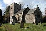 |
| Coachhouse to South West of Gatehouse at Colleton Manor | Chulmleigh | Hayloft | Late 19th century | 25 October 1988 | SS6685214635 50°54′57″N 3°53′44″W / 50.915774°N 3.895476°W |
1165960 |
|
| Congregational Chapel, including Front Walls and Iron Railings | Chulmleigh | School | 1836 | 20 February 1967 | SS6890814300 50°54′48″N 3°51′58″W / 50.913234°N 3.866125°W |
1106706 |
|
| Stables to South of Colleton Manor | Chulmleigh | Tack Room | Late 19th century | 25 October 1988 | SS6687514612 50°54′56″N 3°53′43″W / 50.915573°N 3.895141°W |
1106731 |
|
| The Pack of Cards Including Courtyard Walls Incorporating Bee Boles on North-west Side | Combe Martin | House | Reputedly built as such | 9 March 1953 | SS5833646722 51°12′08″N 4°01′45″W / 51.202096°N 4.029114°W |
1169072 | 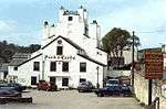 |
| West Challacombe Manor | Combe Martin | Farmhouse | 1953 | 9 March 1953 | SS5864747567 51°12′35″N 4°01′30″W / 51.209766°N 4.024999°W |
1306692 |
|
| Church of Saint John | Countisbury | Church | Probably earlier-Pre 18th century | 25 February 1965 | SS7471549769 51°14′00″N 3°47′45″W / 51.233311°N 3.795868°W |
1289192 | 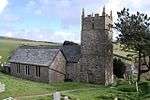 |
| Church of St Peter | West Buckland, East and West Buckland | Parish Church | 15th century | 20 February 1967 | SS6568731307 51°03′55″N 3°55′06″W / 51.065339°N 3.918208°W |
1161310 | 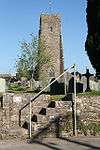 |
| South Stoodleigh Farmhouse Including Attached Outbuildings to Rear | East and West Buckland | Farmhouse | Possible 17th century core | 20 February 1967 | SS6571932314 51°04′28″N 3°55′05″W / 51.074396°N 3.918126°W |
1107567 |
|
| Bunksland Farmhouse and Attached Outbuildings | East Anstey | Farmhouse | Early 15th century | 11 May 1983 | SS8502426271 51°01′27″N 3°38′27″W / 51.024276°N 3.640774°W |
1106670 |
|
| Church of St Michael | East Anstey | Parish Church | 15th century | 20 February 1967 | SS8673026526 51°01′37″N 3°37′00″W / 51.026907°N 3.616539°W |
1325768 | .jpg) |
| Dunsley Farmhouse | East Anstey | Farmhouse | Early 16th century | 15 September 1987 | SS8529126505 51°01′35″N 3°38′13″W / 51.026432°N 3.637042°W |
1106674 |
|
| Church of St John the Baptist | East Down Village, East Down | Church | 1709 | 25 February 1965 | SS6012641803 51°09′30″N 4°00′06″W / 51.158333°N 4.001593°W |
1163326 | 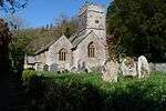 |
| East Down Manor | East Down Village, East Down | Manor House | Late 17th century | 25 February 1965 | SS6004941802 51°09′30″N 4°00′10″W / 51.158305°N 4.002693°W |
1107152 | 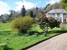 |
| Affeton Castle | East Worlington | House | 1868 | 9 June 1952 | SS7553113697 50°54′33″N 3°46′18″W / 50.909282°N 3.771758°W |
1325448 | 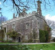 |
| Cobley Farmhouse with Forecourt Wall and Gateway | East Worlington | Farmhouse | Early 17th century | 20 February 1967 | SS7519712054 50°53′40″N 3°46′33″W / 50.894443°N 3.775944°W |
1107331 |
|
| East Worlington House | East Worlington | House | 1965 | 20 February 1967 | SS7748413667 50°54′34″N 3°44′38″W / 50.909431°N 3.743983°W |
1107333 |
|
| Bremridge | Filleigh | House | Part now ruined | 20 August 1951 | SS6934529089 51°02′47″N 3°51′55″W / 51.04625°N 3.865232°W |
1107533 | 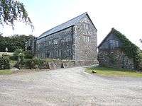 |
| Castle Hill House | Castle Hill, Filleigh | Country House | Late Tudor | 20 February 1967 | SS6711028455 51°02′24″N 3°53′49″W / 51.040039°N 3.896864°W |
1107537 |  |
| Stable Block approximately 5 Metres North East of Castle Hill House Including 2 Pairs of Gatepiers Flanking Its Western End | Castle Hill, Filleigh | Stables | 1843 | 13 May 1987 | SS6720728444 51°02′24″N 3°53′44″W / 51.039962°N 3.895477°W |
1107538 | 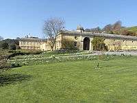 |
| Church of St Paul | Filleigh | Parish Church | 1732 | 20 February 1967 | SS6625628045 51°02′10″N 3°54′32″W / 51.036156°N 3.908887°W |
1107543 | 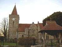 |
| Church of St Peter | Fremington | Parish Church | 13th century | 25 February 1965 | SS5118932562 51°04′23″N 4°07′32″W / 51.073039°N 4.125487°W |
1163217 | .jpg) |
| Fremington Manor House including Entrance Gateway attached to West Side | Fremington | House | C20 | 6 July 1976 | SS5123832554 51°04′23″N 4°07′29″W / 51.072979°N 4.124784°W |
1325314 | .jpg) |
| Gazebo on North Side of Fremington Manor Gardens | Fremington | Gazebo | 1747 | 29 May 1986 | SS5115832682 51°04′27″N 4°07′34″W / 51.074109°N 4.125978°W |
1163261 |
|
| Church of St George | George Nympton | Parish Church | 15th century | 20 February 1967 | SS7003322967 50°59′29″N 3°51′12″W / 50.991385°N 3.853227°W |
1309366 |  |
| Myrtle Farmhouse | Croyde, Georgeham | Farmhouse | 17th century, possibly earlier | 25 February 1965 | SS4439539285 51°07′54″N 4°13′31″W / 51.131644°N 4.225287°W |
1162257 |
|
| Church of St Gregory | Goodleigh, Goodleigh | Church | Late 15th century | 25 February 1965 | SS5984434152 51°05′22″N 4°00′10″W / 51.089508°N 4.002647°W |
1164580 | .jpg) |
| Rigg Side | Goodleigh | Timber Framed House | 1970-1971 | 24 July 1998 | SS6024034327 51°05′28″N 3°59′49″W / 51.091177°N 3.997064°W |
1375758 |
|
| Church of St Thomas of Canterbury | Newton Tracey, Lovacott and Newton Tracey | Parish Church | 13th century | 25 February 1965 | SS5293926879 51°01′21″N 4°05′54″W / 51.022422°N 4.098216°W |
1253508 | 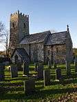 |
| Hoopers Cottage | Horwood, Lovacott and Newton Tracey | House | c. 1600 | 25 February 1965 | SS5020327626 51°01′42″N 4°08′15″W / 51.028427°N 4.137506°W |
1325320 |
|
| Barn Approximately 40 Metres North of Damage Barton | Damage Barton, Ilfracombe | Barn | 1656 | 15 June 1951 | SS4728545673 51°11′23″N 4°11′12″W / 51.189821°N 4.186729°W |
1202938 |
|
| Beara Farmhouse | Hele, Ilfracombe | Farmhouse | 15th century | 17 May 1973 | SS5388647064 51°12′15″N 4°05′34″W / 51.204047°N 4.092904°W |
1207958 |
|
| Chambercombe Manor with Attached Yard Walls | Ilfracombe | Farmhouse | 15th century | 15 June 1951 | SS5326746803 51°12′06″N 4°06′06″W / 51.201543°N 4.101652°W |
1208154 | 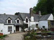 |
| Damage Barton | Damage Barton, Ilfracombe | Farmhouse | 16th century or earlier | 15 June 1951 | SS4728345635 51°11′22″N 4°11′12″W / 51.189479°N 4.186741°W |
1281939 |
|
| Parish Church of Saint Philip and St James | Ilfracombe | Church | 1856 | 16 March 1992 | SS5218847815 51°12′37″N 4°07′03″W / 51.210359°N 4.117502°W |
1292875 | 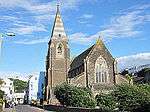 |
| The Quay from Royal Britannia Hotel on West to Pier Hotel on East Including Old Quay Head | Ilfracombe | Steps | 1824-9 | 12 March 1990 | SS5241447822 51°12′38″N 4°06′51″W / 51.21048°N 4.114272°W |
1203010 |
|
| Church of St Thomas | Kentisbury | Church | Dated 1762 | 25 February 1965 | SS6227543831 51°10′37″N 3°58′18″W / 51.17708°N 3.971659°W |
1106810 | .jpg) |
| Broomham Farmhouse | King's Nympton | Farmhouse | 1638 | 20 February 1967 | SS7089321262 50°58′35″N 3°50′25″W / 50.976254°N 3.840374°W |
1152877 |
|
| Capelcombe Farmhouse | King's Nympton | Farmhouse | Early 16th century | 20 February 1967 | SS6889822470 50°59′12″N 3°52′09″W / 50.98666°N 3.869211°W |
1106690 |
|
| Laundry immediately North North West of Kings Nympton Park | Kings Nympton Park, King's Nympton | Wash House | Mid 18th century | 9 June 1952 | SS6726719571 50°57′37″N 3°53′29″W / 50.960232°N 3.891376°W |
1325777 |
|
| Church of St Peter | Knowstone | Parish Church | 15th century | 20 February 1967 | SS8279523076 50°59′42″N 3°40′17″W / 50.995107°N 3.671509°W |
1106680 | 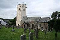 |
| Shapcott Barton | Knowstone | Farmhouse | c. 1600 | 20 February 1967 | SS8464223490 50°59′57″N 3°38′43″W / 50.999202°N 3.645333°W |
1107317 |
|
| Harford Barton (includes adjoining Outbuildings to North) | Harford, Landkey | Farmhouse | Early 17th century | 18 March 1986 | SS6026831849 51°04′08″N 3°59′45″W / 51.068915°N 3.995705°W |
1107685 |
|
| The Old Manor | Landkey Newland, Landkey | House | Late 15th century | 25 February 1965 | SS5905031186 51°03′46″N 4°00′46″W / 51.062659°N 4.012819°W |
1325269 |
|
| Church of St Michael | Loxhore | Parish Church | C15/C16 | 25 February 1965 | SS6168938757 51°07′53″N 3°58′41″W / 51.13134°N 3.978086°W |
1107692 | 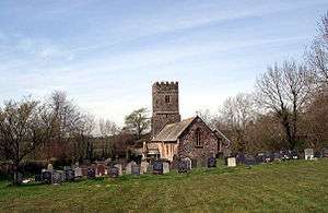 |
| Hill House and adjoining Shippon and detached Kitchen 5 Metres to South | Loxhore | Kitchen | 17th century | 25 February 1965 | SS6216937842 51°07′24″N 3°58′15″W / 51.123233°N 3.97088°W |
1165051 |
|
| Church of St Mary the Virgin | Lynton, Lynton and Lynmouth | Anglican Church | 1741 | 19 July 1950 | SS7206249436 51°13′47″N 3°50′01″W / 51.229729°N 3.833727°W |
1282837 | 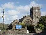 |
| Methodist Church | Lynton, Lynton and Lynmouth | Craft centre | 1910 | 9 June 1995 | SS7184249507 51°13′49″N 3°50′13″W / 51.230318°N 3.836902°W |
1201144 |  |
| Town Hall | Lynton, Lynton and Lynmouth | Town Hall | 1898 | 3 September 1973 | SS7188049514 51°13′49″N 3°50′11″W / 51.230389°N 3.83636°W |
1206608 | 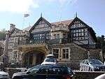 |
| Church of St Mary | Mariansleigh | Bell Tower | 13th century or earlier | 20 February 1967 | SS7440122050 50°59′03″N 3°47′27″W / 50.984113°N 3.790705°W |
1107243 | 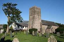 |
| Yeo Farmhouse | Mariansleigh | Farmhouse | Late medieval | 20 February 1967 | SS7603123039 50°59′36″N 3°46′04″W / 50.993356°N 3.767833°W |
1163171 |
|
| Church of St Martin | Martinhoe | Parish Church | Late C13/early 14th century | 25 February 1965 | SS6680248659 51°13′18″N 3°54′31″W / 51.221542°N 3.908729°W |
1106778 |  |
| Barn and Cow House 50 Metres East of Westcott Barton | Westcott, Marwood | Barn | Early 17th century | 25 February 1965 | SS5320438514 51°07′37″N 4°05′57″W / 51.127043°N 4.099168°W |
1107162 |
|
| Meshaw Barton and Walled Forecourt | Meshaw | Farmhouse | Early 16th century | 20 February 1967 | SS7644119265 50°57′34″N 3°45′39″W / 50.959524°N 3.76071°W |
1305732 |
|
| Great Champson Farmhouse | Champson, Molland | Farmhouse | Early to Mid 16th century | 20 February 1967 | SS8023228402 51°02′33″N 3°42′35″W / 51.04245°N 3.709774°W |
1213706 |
|
| West Molland Barton | West Molland Barton, Molland | Farmhouse | Probably earlier-Pre 18th century | 9 June 1952 | SS7932428478 51°02′35″N 3°43′22″W / 51.042943°N 3.722745°W |
1288903 |
|
| Church of St Sabinus (Woolacombe Church) | Woolacombe, Mortehoe | Parish Church | 1910 | 14 November 1985 | SS4613443808 51°10′22″N 4°12′09″W / 51.172755°N 4.202388°W |
1162825 | 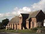 |
| Court House and Garden Wall adjoining to North East | North Molton | House | Late 17th century | 9 June 1952 | SS7362929925 51°03′17″N 3°48′16″W / 51.054723°N 3.804444°W |
1214330 |  |
| Higher Thornham Farmhouse and attached Farmbuildings | Romansleigh | Farmhouse | Circa early 16th century | 20 February 1967 | SS7360818213 50°56′58″N 3°48′02″W / 50.949453°N 3.800662°W |
1171246 |
|
| Lower Kingstree | Romansleigh | Farmhouse | Circa late 15th century or early 16th century | 20 February 1967 | SS7148619456 50°57′37″N 3°49′53″W / 50.960155°N 3.831293°W |
1171258 |
|
| Church of St Peter | Rose Ash | Stocks | Possibly 14th century | 20 February 1967 | SS7875821697 50°58′55″N 3°43′43″W / 50.981875°N 3.728547°W |
1107227 |  |
| North Yarde | Rose Ash | Kitchen | Late medieval | 18 October 1988 | SS7717721244 50°58′39″N 3°45′03″W / 50.977468°N 3.750905°W |
1163493 |
|
| Church of St John | Warkleigh, Satterleigh and Warkleigh | Sundial | Probably 13th century fabric | 20 February 1967 | SS6423222799 50°59′19″N 3°56′09″W / 50.988534°N 3.935772°W |
1258818 | 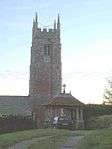 |
| Pair of Lodges 700 Metres East of Youlston Park | Shirwell | Gate Lodge | Late 18th century | 25 February 1965 | SS5909237386 51°07′06″N 4°00′53″W / 51.118386°N 4.014641°W |
1107132 |
|
| Chapel at Honiton Barton | South Molton | Chapel | c. 1730 | 20 August 1951 | SS6888724278 51°00′10″N 3°52′12″W / 51.002907°N 3.870021°W |
1106861 |
|
| Honiton Barton | South Molton | House | 1676 | 20 August 1951 | SS6890724264 51°00′10″N 3°52′11″W / 51.002786°N 3.869731°W |
1106860 |
|
| Kingsland Barton | South Molton | Farmhouse | c. 1640 | 31 October 1986 | SS6989525903 51°01′04″N 3°51′22″W / 51.017741°N 3.856246°W |
1317806 |
|
| Public Market and Assembly Room | South Molton | Assembly Rooms | 1863 | 20 August 1951 | SS7142625793 51°01′02″N 3°50′04″W / 51.017097°N 3.834392°W |
1317914 | 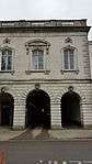 |
| Apiary, 15 Metres South-east of Glebe House | Stoke Rivers | Apiary | Early-mid 19th century | 18 March 1986 | SS6330935335 51°06′04″N 3°57′13″W / 51.100976°N 3.95365°W |
1107661 |
|
| Bydown House | Swimbridge | Country House | Early 19th century | 25 February 1965 | SS6229229394 51°02′50″N 3°57′57″W / 51.047342°N 3.965901°W |
1107662 |
|
| Cob Cottage and the Cottage Including Outbuilding to Rear | Swimbridge | Farmhouse | Late C15/early 16th century | 18 March 1986 | SS6130726487 51°01′16″N 3°58′44″W / 51.02098°N 3.97883°W |
1325296 |
|
| Dean Head, including Apple Store and Coal Shed to Rear | Swimbridge | Farmhouse | Early 16th century | 18 March 1986 | SS6245833668 51°05′09″N 3°57′55″W / 51.085792°N 3.965161°W |
1107663 |
|
| Hannaford House | Hannaford, Swimbridge | House | c. 1760 | 25 February 1965 | SS6069829821 51°03′03″N 3°59′20″W / 51.050795°N 3.988791°W |
1107635 |
|
| Kerscott Farmhouse | Swimbridge | Farmhouse | Early 16th century | 18 March 1986 | SS6317029405 51°02′52″N 3°57′12″W / 51.047651°N 3.953388°W |
1317304 |
|
| Marsh Farmhouse, including Rear Wall to Rear Court Yard | Swimbridge | Farmhouse | 15th century | 18 March 1986 | SS6125630194 51°03′15″N 3°58′52″W / 51.054282°N 3.980978°W |
1165476 |
|
| Stowford Farmhouse | East Stowford, Swimbridge | Farmhouse | Late 16th century or early 17th century | 18 March 1986 | SS6324826703 51°01′24″N 3°57′05″W / 51.023387°N 3.951255°W |
1165612 |
|
| Fishleigh Barton Farmhouse | Tawstock | Farmhouse | 14th century | 25 February 1965 | SS5844424934 51°00′23″N 4°01′08″W / 51.006326°N 4.019017°W |
1253607 |
|
| Gatehouse to Tawstock Court | Tawstock | Gatehouse | 1574 | 25 February 1965 | SS5577629843 51°02′59″N 4°03′32″W / 51.049777°N 4.058974°W |
1253770 | 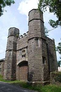 |
| Wick Farmhouse | Tawstock | Farmhouse | 19th century | 11 June 1975 | SS5703327169 51°01′34″N 4°02′24″W / 51.026061°N 4.039997°W |
1253698 |
|
| Church of St Peter | Trentishoe | Parish Church | 15th century | 25 February 1965 | SS6465248609 51°13′14″N 3°56′22″W / 51.220586°N 3.939478°W |
1325745 | .jpg) |
| Badlake Farmhouse | West Anstey | Farmhouse | early to mid 15th century | 20 February 1967 | SS8571927482 51°02′07″N 3°37′53″W / 51.0353°N 3.63125°W |
1107322 |
|
| Church of St Petrock | West Anstey | Parish Church | 14th century | 20 February 1967 | SS8521427490 51°02′07″N 3°38′18″W / 51.035271°N 3.638452°W |
1305803 | .jpg) |
| Manor House | West Down | Manor House | Late 16th century | 25 February 1965 | SS5167242020 51°09′29″N 4°07′21″W / 51.158152°N 4.12249°W |
1162928 |
|
| Eastleigh Barton including Rear Garden Wall Containing Two Bee Boles | Eastleigh, Westleigh | Farmhouse | Early 16th century | 29 May 1986 | SS4887127907 51°01′50″N 4°09′24″W / 51.030604°N 4.156604°W |
1318076 |
|
| Eastleigh Manor House, including Ha Ha to Front on South and East Sides | Eastleigh, Westleigh | Manor House | Late 15th century or Early 16th century | 25 February 1965 | SS4881628003 51°01′53″N 4°09′27″W / 51.031452°N 4.157428°W |
1107611 |
|
| Southcott Barton | Southcott, Westleigh | Farmhouse | c. 1600 | 25 February 1965 | SS4690427574 51°01′38″N 4°11′04″W / 51.02709°N 4.184492°W |
1107574 |
|
| Tapeley Park House | Tapeley Park, Westleigh | Country House | 18th century | 25 February 1965 | SS4777829084 51°02′27″N 4°10′22″W / 51.040891°N 4.172674°W |
1325332 |  |
| East Pilliven Farmhouse and Outbuilding | Witheridge | Farmhouse | 13th century or 14th century | 20 February 1967 | SS8236415168 50°55′26″N 3°40′30″W / 50.923939°N 3.675089°W |
1325504 | |
Notes
- ↑ The date given is the date used by Historic England as significant for the initial building or that of an important part in the structure's description.
- ↑ Sometimes known as OSGB36, the grid reference is based on the British national grid reference system used by the Ordnance Survey.
- ↑ The "List Entry Number" is a unique number assigned to each listed building and scheduled monument by Historic England.
External links
![]() Media related to Grade II* listed buildings in Devon at Wikimedia Commons
Media related to Grade II* listed buildings in Devon at Wikimedia Commons
This article is issued from Wikipedia - version of the 9/20/2016. The text is available under the Creative Commons Attribution/Share Alike but additional terms may apply for the media files.