Grade II* listed buildings in Reigate and Banstead
Surrey shown within England
There are over 20,000 Grade II* listed buildings in England. This page is a list of these buildings in the district of Reigate and Banstead in Surrey. For links to similar articles in relation to the other 10 districts of Surrey see Grade II* listed buildings in Surrey.
| Name | Location | Type | Completed [note 1] | Date designated | Grid ref.[note 2] Geo-coordinates |
Entry number [note 3] | Image |
|---|---|---|---|---|---|---|---|
| Alderstead Farmhouse | Merstham, Reigate and Banstead | House | 18th century | 19 October 1951 | TQ2990254666 51°16′35″N 0°08′20″W / 51.27634°N 0.139026°W |
1377933 | 
|
| Banstead Place | Banstead, Reigate and Banstead | House | Early 18th century | 29 September 1983 | TQ2628159249 51°19′06″N 0°11′21″W / 51.318342°N 0.189291°W |
1178257 |  |
| Browne's Lodge | Reigate and Banstead | House | c. 1780 | 19 October 1951 | TQ2492150374 51°14′20″N 0°12′43″W / 51.238879°N 0.211896°W |
1377963 |  |
| Church of All Saints | Banstead, Reigate and Banstead | Church | Late 12th century | 24 July 1954 | TQ2547159641 51°19′19″N 0°12′03″W / 51.322044°N 0.20077°W |
1029028 | .JPG) |
| Church of St John the Evangelist | Redhill, Reigate and Banstead | Church | Built 1842-43 | 19 October 1951 | TQ2741649387 51°13′46″N 0°10′35″W / 51.229457°N 0.176525°W |
1029141 |  |
| Church of St Katharine | Merstham, Reigate and Banstead | Church | Medieval | 19 October 1951 | TQ2902053798 51°16′07″N 0°09′07″W / 51.268739°N 0.151977°W |
1377942 | 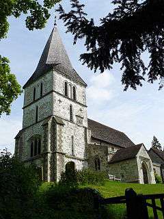 |
| Church of St Mary Magdalene | Reigate and Banstead | Lych Gate | 1908 | 19 October 1951 | TQ2595250160 51°14′12″N 0°11′50″W / 51.236729°N 0.19721°W |
1188125 | _(January_2011).JPG) |
| Church of St Peter | Walton-on-the-Hill, Reigate and Banstead | Church | 15th century | 24 July 1954 | TQ2237755089 51°16′55″N 0°14′48″W / 51.281806°N 0.246709°W |
1377991 | .JPG) |
| Fengates House | Redhill, Reigate and Banstead | House | Mid 18th century | 19 October 1951 | TQ2741350343 51°14′17″N 0°10′34″W / 51.23805°N 0.176228°W |
1377968 |  |
| Flanchford Mill | Leigh, Reigate and Banstead | Watermill | Mid 18th century | 31 March 1977 | TQ2351747960 51°13′03″N 0°13′58″W / 51.217488°N 0.232829°W |
1029111 |  |
| Gatton Town Hall | Gatton Park, Reigate and Banstead | Town hall | 18th century | 19 October 1951 | TQ2745452894 51°15′39″N 0°10′29″W / 51.260967°N 0.174734°W |
1029114 |  |
| Hartswood Manor | Reigate, Reigate and Banstead | House | mid-late 17th century | 19 October 1951 | TQ2498447664 51°12′52″N 0°12′43″W / 51.214509°N 0.211938°W |
1029104 | .jpg) |
| Reigate Heath Baptist Church (Reigate Heath Windmill) | Reigate and Banstead | Post Mill | 1765 | 19 October 1951 | TQ2343550036 51°14′10″N 0°14′00″W / 51.236164°N 0.233288°W |
1029105 |  |
| Ricebridge Farmhouse | Reigate and Banstead | Farmhouse | Early 17th century | 19 October 1951 | TQ2246248924 51°13′35″N 0°14′51″W / 51.226379°N 0.247598°W |
1029072 |
|
| The Baron's | Reigate, Reigate and Banstead | House | 1721 | 19 October 1951 | TQ2554250287 51°14′17″N 0°12′11″W / 51.237961°N 0.203035°W |
1029142 |
|
| The Old Manor | Reigate and Banstead | House | 18th century | 19 October 1951 | TQ2373250994 51°14′41″N 0°13′43″W / 51.24471°N 0.228705°W |
1029144 |
|
| The Old Town Hall | Reigate, Reigate and Banstead | Town Hall | 1728 | 19 October 1951 | TQ2531450249 51°14′16″N 0°12′23″W / 51.237669°N 0.206313°W |
1188608 |  |
| Walton Manor House | Walton-on-the-Hill, Reigate and Banstead | House | 17th century | 24 July 1954 | TQ2210955040 51°16′53″N 0°15′02″W / 51.281423°N 0.250566°W |
1029054 |  |
| Wray Common Mill | Reigate and Banstead | House | 1977 | 19 October 1951 | TQ2689451084 51°14′41″N 0°11′00″W / 51.244825°N 0.183397°W |
1029127 |  |
| 15 and 15a Bell Street | Reigate and Banstead | House | late medieval | 19 October 1951 | TQ2538150214 51°14′14″N 0°12′19″W / 51.23734°N 0.205366°W |
1029128 |
|
| 10 Slipshoe Street | Reigate and Banstead | House | 17th century | 19 October 1951 | TQ2502450353 51°14′19″N 0°12′38″W / 51.238667°N 0.210429°W |
1377960 | |
Notes
- ↑ The date given is the date used by Historic England as significant for the initial building or that of an important part in the structure's description.
- ↑ Sometimes known as OSGB36, the grid reference is based on the British national grid reference system used by the Ordnance Survey.
- ↑ The "List Entry Number" is a unique number assigned to each listed building and scheduled monument by Historic England.
References
English Heritage Images of England
External links
![]() Media related to Grade II* listed buildings in Surrey at Wikimedia Commons
Media related to Grade II* listed buildings in Surrey at Wikimedia Commons
This article is issued from Wikipedia - version of the 3/18/2015. The text is available under the Creative Commons Attribution/Share Alike but additional terms may apply for the media files.