Grand Mesa National Forest
| Grand Mesa National Forest | |
|---|---|
|
IUCN category VI (protected area with sustainable use of natural resources) | |
 | |
 | |
| Location | Delta, Garfield, and Mesa counties, Colorado, United States |
| Nearest city | Grand Junction, CO |
| Coordinates | 39°04′00″N 107°53′00″W / 39.0668°N 107.8834°WCoordinates: 39°04′00″N 107°53′00″W / 39.0668°N 107.8834°W |
| Area | 346,555 acres (1,402.46 km2) |
| Established | December 24, 1892 |
| Governing body | U.S. Forest Service |
| Website | Grand Mesa National Forest |
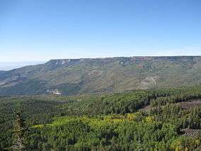
The Grand Mesa National Forest is a U.S. National Forest in Mesa, Delta and Garfield Counties in Western Colorado. It borders the White River National Forest to the north and the Gunnison National Forest to the east. The forest covers most of Grand Mesa and the south part of Battlement Mesa. It has a total area of 346,555 acres (541.49 sq mi, or 1,402.46 km²).[1] It is managed by the United States Forest Service together with Gunnison National Forest and Uncompahgre National Forest from offices in Delta, Colorado. There are local ranger district offices located in Grand Junction.
Originally called Battlement Mesa Forest Reserve, created by Benjamin Harrison on December 24, 1892, it was the third forest reserve created in United States. It is the largest flat top mountain in the world.
See also
References
- ↑ Table 6 - NFS Acreage by State, Congressional District and County - United States Forest Service - September 30, 2007