Granite Historic District
|
Granite Historic District | |
 | |
  | |
| Location | Roughly, area surrounding Old Court Rd. and St. Paul Ave., Granite, Maryland |
|---|---|
| Coordinates | 39°20′36″N 76°50′51″W / 39.34333°N 76.84750°WCoordinates: 39°20′36″N 76°50′51″W / 39.34333°N 76.84750°W |
| Area | 190 acres (77 ha) |
| Built | 1750 |
| Architect | Kennedy, Thomas C. |
| Architectural style | Late Victorian |
| NRHP Reference # | 94001091[1] |
| Added to NRHP | September 22, 1994 |
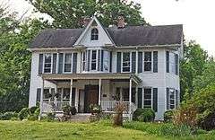
Granite Historic District is a national historic district in Granite, Baltimore County, Maryland, United States. It comprises the focus of a rural quarrying community located in the Patapsco Valley of western Baltimore County, Maryland. It includes two churches, a school, a social hall, former commercial buildings, and houses and outbuildings, representing the period from the initial settlement of the area about 1750 through the early 20th century, when the village achieved its present form. The district also includes the former Waltersville quarry, one of two major granite operations in the region during the period. Granite from the Waltersville and Fox Rock quarries was utilized in construction of the Baltimore & Ohio Railroad in the 1830s, and later in such projects as the Library of Congress, old Treasury Building, and parts of the inner walls of the Washington Monument in Washington, D.C., and numerous other projects in Baltimore city and county.[2]
It was added to the National Register of Historic Places in 1994.[1]
References
- 1 2 National Park Service (2010-07-09). "National Register Information System". National Register of Historic Places. National Park Service.
- ↑ Peter E. Kurtze (March 1994). "National Register of Historic Places Registration: Granite Historic District" (PDF). Maryland Historical Trust. Retrieved 2016-03-01.
External links
- Granite Historic District, Baltimore County, at Maryland Historical Trust
- Boundary Map of the Granite Historic District, Baltimore County, including photo from 1994, at Maryland Historical Trust
| Topics |  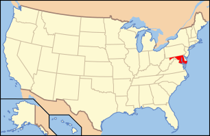 | |
|---|---|---|
| Lists by county | ||
| Lists by city | ||
| Other lists | ||
| ||