Grant County, Wisconsin
| Grant County, Wisconsin | |
|---|---|
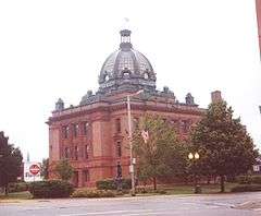 Grant County Courthouse, Armand D. Koch, architect, 1902 | |
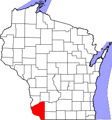 Location in the U.S. state of Wisconsin | |
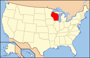 Wisconsin's location in the U.S. | |
| Founded | 1837 |
| Seat | Lancaster |
| Largest city | Platteville |
| Area | |
| • Total | 1,183 sq mi (3,064 km2) |
| • Land | 1,147 sq mi (2,971 km2) |
| • Water | 36 sq mi (93 km2), 3.1% |
| Population | |
| • (2010) | 51,208 |
| • Density | 45/sq mi (17/km²) |
| Congressional district | 3rd |
| Time zone | Central: UTC-6/-5 |
| Website |
www |
Grant County is a county located in the U.S. state of Wisconsin. As of the 2010 census, the population was 51,208.[1] Its county seat is Lancaster.[2]
Grant County comprises the Platteville, WI Micropolitan Statistical Area. It is in the tri-state area of Illinois, Iowa, and Wisconsin, and is crossed by travelers commuting to Madison from a number of eastern Iowan cities, and by residents of northern Illinois traveling to the Twin Cities or La Crosse, Wisconsin.
History
Native American period
What is now Grant County was largely uninhabited prior to contact with Europeans, as it was a border region between the territories of the Kickapoo, Menominee, and Illinois tribes. The only Native American group to have a permanent settlement in the area was the Meskwaki, sometimes known as the Fox, who had a temporary village in what is now the extreme northeast of the county during the mid-1700s.
Spanish period
Between 1520 and 1620 this area was nominally ruled by Spain, though no Spaniard or anyone who claimed loyalty to Spain had ever come within five hundred miles of the region during this time, and as such, Spanish authority went completely unfelt in what is now Grant County, Wisconsin.
French period
The first Frenchmen to reach what is now Grant County were Jacques Marquette and Louis Joliet who explored the region in the spring of 1673, when they set out from what would later become Green Bay. No permanent settlement was made. In 1680 Louis Hennepin also passed through the region that would later become Grant County, also making no permanent settlement. In 1689 Nicholas Perrot passed through the territory and claimed it for the King of France. The first known settlement by a European came in 1725 when a trading post was established by Pierriere Marin. Later the French would abandon it.
British period
The British technically ruled the region during the period in between the French and Indian War and the American Revolution, though no effort was made to settle or administer the region which would eventually become Grant County. After the French abandoned the trading post established by Marin, the next person of European descent to see what is now Grant County was Captain Jonathan Carver, an English colonial from Connecticut who passed through what is now Grant County in 1776 during an attempt to discover the Pacific Ocean.
United States period
In 1783 the British government acknowledged the jurisdiction of the United States over the land east of the Mississippi River, including what is now Grant County. There were no permanent settlers of either European or Native American descent in what is now Grant County since the French trading post established by Marin was abandoned, both Native Americans of the region and the European and White American fur traders who passed through were nomadic, and left no records. Grant County was created as part of Wisconsin Territory in 1837.[3] It was named after an Indian trader; his first name, origins, and eventual fate are all unknown.[4]
Geography
According to the U.S. Census Bureau, the county has a total area of 1,183 square miles (3,060 km2), of which 1,147 square miles (2,970 km2) is land and 36 square miles (93 km2) (3.1%) is water.[5]
Major highways
Airports
- KPVB - Platteville Municipal Airport serves the county and surrounding communities.
- 73C - Lancaster Municipal Airport enhances county service.
Adjacent counties
- Crawford County, Wisconsin - north
- Richland County, Wisconsin - northeast
- Iowa County, Wisconsin - east
- Lafayette County, Wisconsin - east
- Jo Daviess County, Illinois - southeast
- Dubuque County, Iowa - south
- Clayton County, Iowa - west
Demographics
| Historical population | |||
|---|---|---|---|
| Census | Pop. | %± | |
| 1840 | 3,926 | — | |
| 1850 | 16,169 | 311.8% | |
| 1860 | 31,189 | 92.9% | |
| 1870 | 37,979 | 21.8% | |
| 1880 | 37,852 | −0.3% | |
| 1890 | 36,651 | −3.2% | |
| 1900 | 38,881 | 6.1% | |
| 1910 | 39,007 | 0.3% | |
| 1920 | 39,044 | 0.1% | |
| 1930 | 38,469 | −1.5% | |
| 1940 | 40,639 | 5.6% | |
| 1950 | 41,460 | 2.0% | |
| 1960 | 44,419 | 7.1% | |
| 1970 | 48,398 | 9.0% | |
| 1980 | 51,736 | 6.9% | |
| 1990 | 49,264 | −4.8% | |
| 2000 | 49,597 | 0.7% | |
| 2010 | 51,208 | 3.2% | |
| Est. 2015 | 52,250 | [6] | 2.0% |
| U.S. Decennial Census[7] 1790–1960[8] 1900–1990[9] 1990–2000[10] 2010–2014[1] | |||
As of the census[11] of 2000, there were 49,597 people, 18,465 households, and 12,390 families residing in the county. The population density was 43 people per square mile (17/km²). There were 19,940 housing units at an average density of 17 per square mile (7/km²). The racial makeup of the county was 98.23% White, 0.52% Black or African American, 0.13% Native American, 0.46% Asian, 0.01% Pacific Islander, 0.14% from other races, and 0.50% from two or more races. 0.56% of the population were Hispanic or Latino of any race. 52.0% were of German, 9.2% English, 8.8% Irish, 6.6% American and 6.4% Norwegian ancestry according to Census 2000.
There were 18,465 households out of which 30.50% had children under the age of 18 living with them, 56.10% were married couples living together, 7.50% had a female householder with no husband present, and 32.90% were non-families. 26.00% of all households were made up of individuals and 12.10% had someone living alone who was 65 years of age or older. The average household size was 2.51 and the average family size was 3.03.
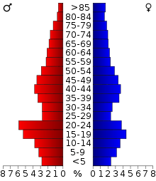
In the county, the population was spread out with 23.70% under the age of 18, 14.60% from 18 to 24, 24.80% from 25 to 44, 21.60% from 45 to 64, and 15.30% who were 65 years of age or older. The median age was 36 years. For every 100 females there were 103.00 males. For every 100 females age 18 and over, there were 102.00 males.
Government and infrastructure
The Wisconsin Secure Program Facility (WSPF), a Wisconsin Department of Corrections prison for men, is located in Boscobel in Grant County.[12][13]
Communities
Cities
- Boscobel
- Cuba City (partly in Lafayette County)
- Fennimore
- Lancaster (county seat)
- Platteville
Villages
- Bagley
- Bloomington
- Blue River
- Cassville
- Dickeyville
- Hazel Green (partly in Lafayette County)
- Livingston (partly in Iowa County)
- Montfort (partly in Iowa County)
- Muscoda (partly in Iowa County)
- Mount Hope
- Patch Grove
- Potosi
- Tennyson
- Woodman
Towns
- Beetown
- Bloomington
- Cassville
- Castle Rock
- Clifton
- Ellenboro
- Fennimore
- Glen Haven
- Harrison
- Hazel Green
- Hickory Grove
- Jamestown
- Liberty
- Lima
- Little Grant
- Marion
- Millville
- Mount Hope
- Mount Ida
- Muscoda
- North Lancaster
- Paris
- Patch Grove
- Platteville
- Potosi
- Smelser
- South Lancaster
- Waterloo
- Watterstown
- Wingville
- Woodman
- Wyalusing
Census-designated places
Unincorporated communities
- Annaton
- Arthur
- Beetown
- Bigpatch
- British Hollow
- Brodtville
- Buena Vista
- Burton
- Castle Rock
- Centerville
- Cornelia
- Diamond Grove
- Ellenboro
- Elmo
- Fair Play
- Five Points
- Flora Fountain
- Georgetown
- Hickory Grove
- Homer
- Hurricane
- Lancaster Junction
- Louisburg
- McCartney
- Millville
- Mount Ida
- North Andover
- Prairie Corners
- Preston
- Rockville
- Rutledge
- Saint Rose
- Shady Dell
- Sinsinawa
- Stitzer
- Union
- Van Buren
- Werley
- Wyalusing
Ghost town
Notable people
- Willard H. Burney, member of the Nebraska House of Representatives[14]
- B. W. Countryman, member of the South Dakota House of Representatives[15]
- John Lewis Dyer, Methodist circuit rider missionary in Minnesota and Colorado; lead miner in Grant County prior to 1848[16]
- William Garner Waddel, member of the South Dakota Senate[17]
See also
- National Register of Historic Places listings in Grant County, Wisconsin
- Upper Mississippi River National Wildlife and Fish Refuge
Footnotes
- 1 2 "State & County QuickFacts". United States Census Bureau. Retrieved January 18, 2014.
- ↑ "Find a County". National Association of Counties. Retrieved 2011-06-07.
- ↑ "Wisconsin: Individual County Chronologies". Wisconsin Atlas of Historical County Boundaries. The Newberry Library. 2007. Retrieved August 13, 2015.
- ↑ Castello N. Holford History of Grant County, Wisconsin. Chicago: Western Historical Company, 1881, pp. 7-9.
- ↑ "2010 Census Gazetteer Files". United States Census Bureau. August 22, 2012. Retrieved August 4, 2015.
- ↑ "County Totals Dataset: Population, Population Change and Estimated Components of Population Change: April 1, 2010 to July 1, 2015". Retrieved July 2, 2016.
- ↑ "U.S. Decennial Census". United States Census Bureau. Retrieved August 4, 2015.
- ↑ "Historical Census Browser". University of Virginia Library. Retrieved August 4, 2015.
- ↑ Forstall, Richard L., ed. (March 27, 1995). "Population of Counties by Decennial Census: 1900 to 1990". United States Census Bureau. Retrieved August 4, 2015.
- ↑ "Census 2000 PHC-T-4. Ranking Tables for Counties: 1990 and 2000" (PDF). United States Census Bureau. April 2, 2001. Retrieved August 4, 2015.
- ↑ "American FactFinder". United States Census Bureau. Retrieved 2011-05-14.
- ↑ "Boscobel city, Wisconsin." U.S. Census Bureau. Retrieved on October 10, 2010.
- ↑ "Wisconsin Secure Program Facility." Wisconsin Department of Corrections. Retrieved on October 10, 2010.
- ↑ "Willard H. Burney (1857-1943)". The Political Graveyard. Retrieved October 6, 2012.
- ↑ "B. W. Countryman (b. 1867)". Political Graveyard. Retrieved October 10, 2013.
- ↑ "Jim Fagan, Snowshoes, Saloons, and Salvation: The Life And Times Of a 19th Century Colorado Pioneer Preacher, December 20, 2004". snowshoemag.com. Retrieved January 18, 2014.
- ↑ "William Garner Waddel". Political Graveyard. Retrieved November 23, 2013.
Further reading
- Commemorative Biographical Record of the Counties of Rock, Green, Grant, Iowa, and Lafayette, Wisconsin, Containing Biographical Sketches of Prominent and Representative Citizens, and of Many of the Early Settled Families. Chicago: J. H. Beers and Co., 1901.
- History of Grant County, Wisconsin. Chicago: Western Historical Company, 1881.
External links
- Grant County Official Government Website
- Grant County map from the Wisconsin Department of Transportation
- Grant County Health and Demographic Data
- Grant County Sheriff's Office
 |
Crawford County | Richland County | | |
| Clayton County, Iowa | |
Iowa County and Lafayette County | ||
| ||||
| | ||||
| Dubuque County, Iowa | Jo Daviess County, Illinois |
Municipalities and communities of Grant County, Wisconsin, United States | ||
|---|---|---|
| Cities | | |
| Villages | ||
| Towns |
| |
| CDPs | ||
| Unincorporated communities |
| |
| Ghost town | ||
| Footnotes | ‡This populated place also has portions in an adjacent county or counties | |
Coordinates: 42°52′N 90°43′W / 42.86°N 90.71°W