Gratiot Community Airport
| Gratiot Community Airport | |||||||||||||||
|---|---|---|---|---|---|---|---|---|---|---|---|---|---|---|---|
 | |||||||||||||||
| IATA: AMN – ICAO: KAMN – FAA LID: AMN | |||||||||||||||
| Summary | |||||||||||||||
| Airport type | Public | ||||||||||||||
| Owner | City of Alma & County of Gratiot | ||||||||||||||
| Serves | Alma, Michigan | ||||||||||||||
| Elevation AMSL | 754 ft / 230 m | ||||||||||||||
| Coordinates | 43°19′20″N 084°41′17″W / 43.32222°N 84.68806°W | ||||||||||||||
| Map | |||||||||||||||
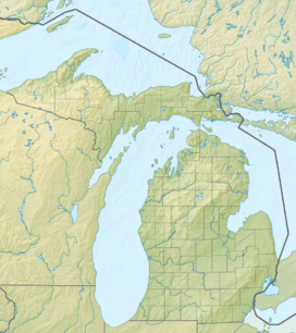 AMN  AMN Location of airport in Michigan/United States | |||||||||||||||
| Runways | |||||||||||||||
| |||||||||||||||
| Statistics (2007) | |||||||||||||||
| |||||||||||||||
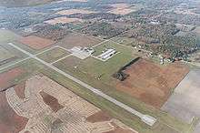
Gratiot Community Airport (IATA: AMN, ICAO: KAMN, FAA LID: AMN) is a public use airport located three nautical miles (6 km) southwest of the central business district of Alma, a city in Gratiot County, Michigan, United States. It is owned by the city and county.[1] It is included in the Federal Aviation Administration (FAA) National Plan of Integrated Airport Systems for 2017–2021, in which it is categorized as a local general aviation facility.[2]
The airport is staffed between 8am and 6pm. It is accessible by road from Seaman Rd, and is close to U.S. Highway 127.
Facilities and aircraft
Gratiot Community Airport covers an area of 631 acres (255 ha) at an elevation of 754 feet (230 m) above mean sea level. It has two asphalt paved runways: 9/27 is 5,004 by 75 feet (1,525 x 23 m) and 18/36 is 3,197 by 75 feet (974 x 23 m).[1]
For the 12-month period ending December 31, 2007, the airport had 9,500 general aviation aircraft operations, an average of 26 per day. At that time there were 28 aircraft based at this airport: 79% single-engine and 21% multi-engine.[1]
References
- 1 2 3 4 FAA Airport Master Record for AMN (Form 5010 PDF). Federal Aviation Administration. Effective April 5, 2012.
- ↑ "List of NPIAS Airports" (PDF). FAA.gov. Federal Aviation Administration. 21 October 2016. Retrieved 25 November 2016.
External links
- Gratiot Community Airport information from Greater Gratiot Development, Inc.
- Three Point Aviation, the fixed-base operator (FBO)
- Aerial image as of April 1998 from USGS The National Map
- FAA Terminal Procedures for AMN, effective November 10, 2016
- Resources for this airport:
- FAA airport information for AMN
- AirNav airport information for KAMN
- ASN accident history for AMN
- FlightAware airport information and live flight tracker
- NOAA/NWS latest weather observations
- SkyVector aeronautical chart, Terminal Procedures