Great Belt
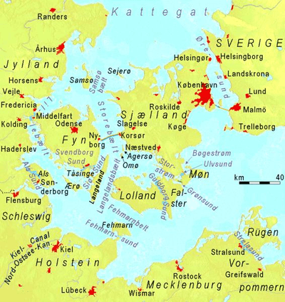
The Great Belt, (Danish: Storebælt), is a strait between the major islands of Zealand (Sjælland) and Funen (Fyn) in Denmark. It is one of the three Danish Straits.
Effectively dividing Denmark in two, the Belt was served by the Great Belt ferries from the late 19th century until the islands were connected by the Great Belt Fixed Link in 1997–98.
Geography
The Great Belt is the largest and most important of the three Danish Straits that connect the Baltic Sea to the Kattegat strait and Atlantic Ocean. The others are the Øresund and the Little Belt straits.
The Great Belt is 60 km (37 miles) long and 16–32 km (10–20 miles) wide. It flows around two major islands: Samsø in the north and Langeland to the south. At Sprogø the Great Belt divides into the East Channel and the West Channel. Both are traversed by the Great Belt Bridge, but a tunnel also runs under the East Channel.
Geology
In pre-glacial times a river, which the Baltic Sea basin then contained and which geologists call the Eridanos, must have passed through the region. So also did the Eemian Sea, just prior to the last glaciation, which covered the entire region with ice thousands of metres (many more thousands of feet) thick. Today's topography is totally post-glacial. The Great Belt was eroded into existence by streams passing between the Ancylus Lake and the Kattegat. Currently it is a drowned channel.
It is possible to speak of northern and southern zones beneath the surface. The northern one consists of two v-shaped cuts more than 50 m (160 ft) deep. The southern one has a relatively shallow bottom, 30 m (100 ft) deep, showing the tops of riverine and lacustrine sediments. This configuration gives evidence that for most of its life the Great Belt hosted an outward, downhill flow.
The northern zone is located in the sea off the north coast of Zeeland. The southern zone is just south of Langeland, leading into the Kieler Bucht, or Bay of Kiel. The Fehmarn Belt then connects the Kieler Bucht to the Lübecker Bucht, or Bay of Lübeck, to the south of Lolland. The Bay of Lübeck is open to the Baltic sea.
The current channel of the Great Belt was created by a relatively high fresh water phase of the rising Yoldia Sea breaking through to the lower Kattegat levels at about 10,000 BP. At that time the exposed northern zone was a valley less than 1 km (0.62 mi) wide.
The Yoldia sea continued to drain and levels in the Kattegat continued to rise. By 9500 BP the outward flow stopped and the sea proper began to penetrate the enlarged Great Belt, turning it brackish very slowly. During the Ancylus Lake phase, 9500-8000 BP, the Great Belt was an extension of the Kattegat. At the end of that time rising Kattegat levels broke into the Ancylus lake, creating the Littorina Sea.
Biology
The Great Belt is home to some popular fish: flatfish, sea trout, Atlantic cod, Atlantic mackerel and garfish, which are fished avidly for sport and for sale. In the 1800s and earlier, harbour porpoises were targeted by whalers in the Belt areas.[1] Today a large and rising population of harbour porpoise lives in the Belts.[2]
International waterway
The Great Belt was historically navigable to ocean-going vessels. It still is used, despite a few collisions and near collisions with the Great Belt Bridge. The Danish navy monitors maritime traffic in the waters around the Great Belt.
In the reign of king Eric of Pomerania the Danish government began to receive a large part of its income from the so-called Sound Dues toll on international merchant ships passing through the Øresund. Non-Danish vessels were restricted to the Øresund channel. Merchants paid the tax under threat of having their vessels sunk or confiscated.
During the middle of the 19th century, this practice became a diplomatic liability and the Danish government agreed to terminate it, achieving an international financial compensation in return. Danish waterways were consequently opened to foreign shipping. The eastern half of the Great Belt is an international waterway, legally based on the 1857 Copenhagen Convention.[3] The western half of the Great Belt (between Funen and Sprogø) and all other parts of the Danish straits are Danish territorial waters and subject to Danish jurisdiction.
See also
- Great Belt Fixed Link — bridge and tunnel.
- Great Belt Power Link — electrical power cable.
- Danish Straits — includes Great Belt.
- Little Belt — strait between Jutland and Funen.
- Øresund — strait between Zealand and Sweden.
- March across the Belts
| Wikimedia Commons has media related to Storebælt (Great Belt). |
References
- ↑ Hvaler.dk: Marsvin i Danmark. Retrieved 21 October 2016.
- ↑ Miljø- og Fødevareministeriet (19 June 2013): Marsvin trives i de indre danske farvande. Retrieved 21 October 2016.
- ↑ "Maritime Law". UNESCO. Retrieved 2009-06-16.
Coordinates: 55°19′59″N 11°00′00″E / 55.333°N 11.000°E