Great Colonial Hurricane of 1635
| Category 4 major hurricane (SSHWS/NWS) | |
| Formed | August 1635 |
|---|---|
| Dissipated | August 25, 1635 |
| Highest winds |
1-minute sustained: 130 mph (215 km/h) |
| Lowest pressure |
≤ 930 mbar (hPa); 27.46 inHg (Estimated [1]) |
| Fatalities | 46+ direct |
| Areas affected | Virginia, Long Island, New England, other areas? (Information scarce) |
| Part of the 1635 Atlantic hurricane season | |
The Great Colonial Hurricane of 1635 was a severe hurricane which in August of that year brushed Virginia and then passed over southeastern New England. Though accounts of the storm are very limited, it was most likely the most intense hurricane to hit New England since European colonization.
Meteorological history
The first recorded mention of the Great Colonial Hurricane was on August 24, 1635, at the Virginia Colony at Jamestown.[2] Though it did affect Jamestown as a major hurricane, no references to damage by the hurricane can be found, probably because the hurricane evidently moved past rapidly, well east of the settlement.
Governors John Winthrop of Massachusetts Bay Colony and William Bradford of Plymouth Colony recorded accounts of the Great Colonial Hurricane. Both describe high winds, 14 to 20 foot storm surges along the south-facing coasts of Massachusetts and Rhode Island, and great destruction.[1]
Impact
Much of the area between Providence, Rhode Island and the Piscataqua River was damaged by the GCH; some damage was still noticeable 50 years later. Governor Bradford wrote that the storm drowned seventeen Native Americans and toppled or destroyed thousands of trees; many houses were also flattened.
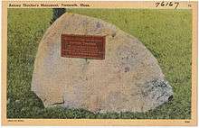
The small barque Watch and Wait, owned by a Mr. Isaac Allerton, foundered in the storm off Cape Ann with 23 people aboard. The only survivors were Antony Thacher and his wife, who reached Thacher Island. Thacher later wrote an account of the shipwreck.
In Narragansett Bay, the tide was 14 feet (4.3 m) above the ordinary tide and drowned eight Native Americans fleeing from their wigwams. The highest ever such recorded value for a New England Hurricane, a 22-foot (6.7 m) storm tide, was recorded in some areas. The town of Plymouth suffered severe damage with houses blown down. The wind cut great mile-long sections of complete blowdown in the woods near Plymouth and elsewhere in eastern Massachusetts.
It also destroyed Plymouth Colony's Aptucxet Trading Post (on the site of present-day Bourne, Massachusetts).
The Boston area did not suffer from the tide as did areas just to its south. The nearest surge swept over the low-lying tracts of Dorchester, ruining the farms and landscape (from the accounts of Bradford and Winthrop).
Modern analysis
The Hurricane Research Division of the Atlantic Oceanographic and Meteorological Laboratory of NOAA has conducted a Re-Analysis Project to re-examine the National Hurricane Center's data about historic hurricanes. In association with the Project, Brian Jarvinen, formerly of NHC, used modern hurricane and storm surge computer models to recreate a storm consistent with contemporary accounts of the GCH.[1]
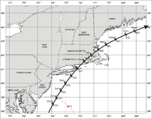
Jarvinen estimated that the GCH was probably a Cape Verde-type hurricane, considering its intensity, which took a track similar to the Great Atlantic Hurricane of 1944 and Hurricane Edna of 1954. The storm's eye would have struck Long Island before moving between Boston and Plymouth. It would likely have been a Category 4 or 5 hurricane further south in the Atlantic, and it was at least a strong Category 3 hurricane at landfall with 125 mph (201 km/h) sustained winds and a central pressure of 938 mbar (27.7 inHg) at the Long Island landfall and 939 mbar (27.7 inHg) at the mainland landfall. This would be the most intense known hurricane landfall north of the Carolinas and Mid-Atlantic states. Jarvinen noted that the GCH may have caused the highest storm surge along the east coast of the U.S. in recorded history: 20 feet (6.1 m) near the head of Narragansett Bay. He concluded that "this was probably the most intense hurricane in New England history."[1]
An erosional scarp in the western Gulf of Maine may be a trace of the Great Colonial Hurricane.[3]
See also
- List of tropical cyclones
- List of Atlantic hurricanes
- List of New England hurricanes
- Angel Gabriel (ship)
References
- 1 2 3 4 Jarvinen, Brian R. (2006). "Storm Tides in Twelve Tropical Cyclones (including Four Intense New England Hurricanes)" (PDF). Report for FEMA/National Hurricane Center.
- ↑ Seventeenth Century Virginia Hurricanes
- ↑ Buynevich, Ilya V.; FitzGerald, Duncan M. & Goble, Ronald J. (2007). "A 1500 yr record of North Atlantic storm activity based on optically dated relict beach scarps". Geology. 35 (6): 543–546. Bibcode:2007Geo....35..543B. doi:10.1130/G23636A.1.
- Woods Hole Currents: Digging Into Hurricanes
- Timeline: U.S. Storm Disasters
- Hurricane timeline: 1495 to 1800
Further reading
- Besonen, M. R.; Bradley, R. S.; Mudelsee, M.; Abbott, M. B.; Francus, P. (2008). "A 1,000-year, annually-resolved record of hurricane activity from Boston, Massachusetts". Geophysical Research Letters. 35 (14): L14705. Bibcode:2008GeoRL..3514705B. doi:10.1029/2008GL033950.
- Boose, Emery R.; Chamberlin, Kristen E.; Foster, David R. (2001). "Landscape and Regional Impacts of Hurricanes in New England". Ecological Monographs. Ecological Society of America. 71 (1): 27–48. doi:10.2307/3100043. JSTOR 3100043.
- Chapman, D. J. "Our southern summer storm." Report from National Weather Service Office, Norfolk, Virginia.
- Snow, Edward Rowe (1943), Great storms and famous shipwrecks of the New England coast, 1495713: The Yankee Publishing, p. 338, OCLC 1495713
External links
- The Great Hurricane of 1635 and the Legend of Thacker Island by Keith C. Heidorn