Great Darling Anabranch
| Great Darling | |
| Anabranch | |
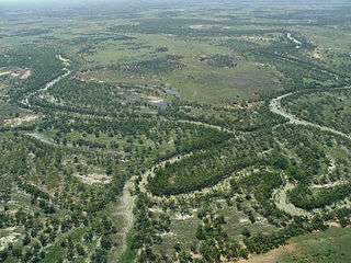 The Great Darling Anabranch in flood, December 2010. | |
| Country | Australia |
|---|---|
| State | New South Wales |
| Part of | Murray River, Murray-Darling basin |
| Source | Darling River |
| Mouth | confluence with Murray River |
| - location | Wentworth |
| Length | 460 km (286 mi) |
The Great Darling Anabranch, commonly called the Darling Anabranch, is an anabranch and ancestral path of the Darling River in the lower Murray-Darling Basin in Australia.
Course and features
The anabranch flows approximately 460 kilometres (290 mi) from its offtake on the Darling River, southward to the Murray River. There are approximately twenty ephemeral deflation basin lakes, called the Anabranch Lakes, associated with the Darling Anabranch of which several are over 5,000 hectares (12,000 acres) in size. The Anabranch Lakes and associated marginal vegetation are listed in the Directory of Important Wetlands in Australia and collectively cover an area of 269,000 hectares (660,000 acres).[1]
The Darling Anabranch was managed by Indigenous Australians prior to European settlement and is rich in archaeological cultural material and evidence of Aboriginal occupation.[2] The Darling Anabranch is a naturally ephemeral system. After the completion of the Menindee Lakes scheme in the 1960s the system was managed as a permanent water supply for stock and domestic water use for adjacent landholders. A series of 17 weir pools were replenished with an annual replenishment flow, most of which evaporated. Over the 40 years of this flow management there was a decline in the health of the system, including poor water quality, decreased numbers of native fish and a decline in aquatic vegetation.[3]
In 2007 a pipeline was constructed along the length of the Darling Anabranch to supply water to adjacent landholders. The Darling Anabranch was returned to an ephemeral system, with the removal of most structures within the channel, and the first dry phase for over four decades.[2]
Initial results from a ten-year monitoring program have showed a marked ecological response to the restoration of the Darling Anabranch.[2] Monitoring began in September 2010 at the breaking of the 'millennium drought', and detected a strong vegetation response including significant increases in riparian tree condition and in the condition of Lignum, a keystone species on the floodplains of the Murray-Darling Basin.[4] The return of the Darling Anabranch to an ephemeral system also increased native fish diversity, and the system is thought to be crucial to maintaining the Murray-Darling Basin native fish community through provision of important habitat and food resources for juvenile life stages during times of flood.[2]
References
- ↑ Winning, G.; Murray, M. (1992). "Darling Anabranch Lakes - NSW020". Directory of Important Wetlands in Australia. Australian Government, Department of Sustainability, Environment, Water, Populations and Communities.
- 1 2 3 4 Bogenhuber, D.; Linklater, D.; Pay, T.; Stoffels, R.; Healy, S. (2013). The Darling Anabranch Adaptive Management Monitoring Program Final Report 2010-2013 Baseline to a decade. NSW Office of Environment and Heritage. The Murray-Darling Freshwater Research Centre, MDFRC Publication.
- ↑ Nias, D. (2002). The Darling Anabranch Management Plan: A proposal for the future of the Darling Anabranch. Wentworth: The Great Anabranch of the Darling Water Trust.
- ↑ Roberts, J.; Marston, F. (2011). Water regime for wetland and floodplain plants: A source book for the Murray-Darling Basin. Canberra: National Water Commission.
External links
Coordinates: 34°05′14″S 141°46′37″E / 34.0872°S 141.7769°E