Great Flood of 1968

The Great Flood of 1968 was a flood caused by a pronounced trough of low pressure which brought exceptionally heavy rain and thunderstorms to South East England[1] and France in mid-September 1968, with the worst on Sunday 15 September 1968, and followed earlier floods in South West England during July.
July Storm
A Spanish plume[2] weather pattern saw a low over the northwest of Spain track across the Bay of Biscay, hot and humid air advected to the eastern side of the low leading to severe storms.[3] The wake of the storm left 7 fatalities in the United Kingdom.[1]
Chew Stoke Flooding, July 1968
In south-west England the River Chew suffered a major flood in 1968 with serious damage to towns and villages along its route, including sweeping away the bridge at Pensford.[4]
On 10 July 1968, torrential rainfall, with 175 millimetres (6.9 in) falling in 18 hours on Chew Stoke, double the area's average rainfall for the whole of July,[5] led to widespread flooding in the Chew Valley, and water reached the first floor of many buildings.[6] The damage in Chew Stoke was not as severe as in some of the surrounding villages, such as Pensford where it swept away the bridge over the A37 and damaged the railway viaduct so badly that it never reopened.[4] It also flooded 88 properties in Chew Magna with many being inundated with 8 feet (2.4 m) of water.[5] Fears that the Chew Valley Lake dam would be breached caused considerable anxiety.[4][7]
On the southern side of the Mendip Hills at Cheddar the flow of water swept large boulders down the gorge and damaged the cafe and entrance to Gough's Cave,[8] washing away cars.[9] In the cave itself the flooding lasted for three days.[10]
Pforzheim Tornado
Pforzheim, (West) Germany and its surrounding areas were hit by a rare tornado on 10 July 1968, shortly before 22:00. It had strength F4 on the Fujita scale. Two persons died and more than 200 were injured, and 1750 buildings were damaged. Across the town between Büchenbronn ward and the village of Wurmberg the storm caused severe damage to forest areas (i.e. most trees fell to the ground). During the first night and the following days the soldiers of the French 3rd Hussar Regiment and a US Army Unit, which were still stationed at the Buckenberg Barracks, helped clear the streets of many fallen trees (especially in the Buckenberg/Haidach area). It took about four weeks to carry out the most necessary repairs on buildings. The overhead electric contact wires for the electric trolleybuses then still operating in town and the streetcar transport system to the village of Ittersbach were never repaired; those transport systems were retired.
September Storm
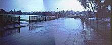
South East England Flooding, September 1968
The areas worst hit were Crawley, East Grinstead, Horley, Lewisham, Petersfield, Hampshire, Redhill, Tilbury, Tunbridge Wells and Tonbridge. [11]
On 15 September 1968, the 9:50 Charing Cross to Hastings was diverted along the Edenbridge line, but was surrounded by flood water at Edenbridge railway station. 150 passengers spent 12 hours stuck on the train.
France
In the first seven hours of 15 September 1968 three inches of rain fell on Nice. In Toulon a cyclist was killed by an electricity cable that had fallen into the flooded road. The wine harvest was seriously damaged.[12]
See also
References
- 1 2 "Wednesday 10 July 1968" (PDF). Met Office. Retrieved 26 March 2012.
- ↑ "Spanish Plume". Meteogroup. Retrieved 3 November 2012.
- ↑ "Pforzheim 1968". Thomas Sävert. Retrieved 26 March 2012.
- 1 2 3 "The great flood of 1968". Memories of Bristol. Archived from the original on 2 May 2006. Retrieved 2006-01-04.
- 1 2 Richley, Rob (June 2008). The Chew Valley floods of 1968. Exeter: Environment Agency.
- ↑ Hucker, Ernest (1997). Chew Stoke Recalled in Old Photographs. Ernest Hucker. ISBN 0-9531700-0-4.
- ↑ "Memories of Bristol's Weather – The Great Flood of 1968". bristolhistory.com. Retrieved 2007-07-03.
- ↑ "40 years since the Great Gorge Flood". Western Mercury. 10 July 2008. Retrieved 24 February 2011.
- ↑ "The Chew Valley floods of 1968" (PDF). Environment Agency. Retrieved 24 February 2011.
- ↑ Donovan, D.T. (2006). "Gough's Cave, Cheddar, Somerset. Quaternary Stratigraphy" (PDF). Proceedings of the University of Bristol Spelæological Society. 24 (1): 17–35. Retrieved 24 February 2011.
- ↑ Staff reporter (17 September 1968). "Good neighbours ease the burden in flood areas". The Times.
- ↑ "Storm havoc in south France". The Times. 16 September 1968. p. 1.