Green Island (Western Australia)

Green Island is an island in Oyster Harbour located approximately 6.5 kilometres (4 mi) northeast of Albany in Western Australia.
The island has a total area of 2 hectares (5 acres) and was designated as a Class 1A Nature Reserve in 1988.[1]
The nearest point on the mainland, Bayonet Head, is located approximately 750 metres (2,461 ft) North West of the island.
History
Green Island was named by George Vancouver, who also named Oyster Harbour when he visited the area in 1791. It is one of only four permanent pelican breeding grounds in Western Australia, the others being Mandurah, Shark Bay and Rockingham. The breeding pelicans can be seen from the Kalgan Queen Riverboat, as the Island itself is a reserve.[2]
When the colony in Albany was first settled in 1826, Green Island was planted for vegetables. By 1830 it supported a vegetable garden, and a hut was erected on the island for the gardener to live in.[3]
In 1827 a group of sealers took 5 Aborigines to Green Island to catch birds. The sealers rowed away, leaving the Aborigines behind, then returned the next day bringing water. The Aborigines attempted to take the boat, and the sealers fired on them killing one Aboriginal man.[4] The remaining Aborigines were removed to Michaelmas Island and left there making "great lamentations".[4]
In 1991 the government department Fisheries Western Australia granted a fish farm license to the company Ocean Foods who have leases North and North East of Green Island where blue mussels are farmed".[5]
Fauna
The island is noted as an important breeding ground for small numbers of the Australian pelican. It was estimated in 1993 that 7 active nests were located on the island.[6]
-

Green Island from Bayonet Head
-
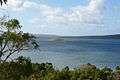
Green Island in Oyster Harbour from the lookout at Bayonet Head
See also
- Other similarly named Western Australian islands include
| Name | Coordinates | Remarks |
|---|---|---|
| Green Island (Kimberley coast) | 15°28′38″S 124°35′57″E / 15.47722°S 124.59917°E | In the Kimberley Region, just South of Augustus Island |
| Green Island (Ord River) | 15°28′42″S 128°18′55″E / 15.47833°S 128.31528°E | Located in the Ord River |
| Green Islands (Western Australia) | 30°40′57″S 115°06′15″E / 30.68250°S 115.10417°E | Near The Pinnacles, Buller Ialand and Wedge Island |
| Green Island (Rottnest Island) | 32°01′03″S 115°29′50″E / 32.01750°S 115.49722°E | South end of Nancy Cove, Rottnest Island |
| Green Island (Western Australia) | 34°59′11″S 117°56′59″E / 34.98639°S 117.94972°E | In Oyster Harbour, King George Sound - this page - NE of Albany; north of HMAS Perth (D 38) |
| Green Islands (Western Australia) | 35°07′38″S 117°51′44″E / 35.12722°S 117.86222°E | Due south of Albany; SW of HMAS Perth (D 38) |
References
- ↑ "Terrestrial Protected Areas of WA". 2004. Retrieved 2010-10-14.
- ↑ "Albany, WA". 2003. Retrieved 2008-04-23.
- ↑ "Complicating the Friendly Frontier - Snake Bite, Medicine and Sorcery at King George Sound, 1830" (PDF). 2004. Retrieved 2008-04-14.
- 1 2 "SIOE 2002: Albany & SE Western Australia; Major Edmund Lockyer's "...complete Set of Pirates"". 2009. Retrieved 2012-01-12.
- ↑ "Albany Waterways Resource Book". 1999. Retrieved 2010-10-12.
- ↑ "Aussie Heritage - Oyster Harbour". 2007. Retrieved 2008-04-17.
Coordinates: 34°59′11″S 117°56′59″E / 34.98639°S 117.94972°E