Coordinates: 53°49′53″N 1°42′44″W / 53.831428°N 1.712172°W / 53.831428; -1.712172
Greengates is a small suburban area in the north-east of the city of Bradford, West Yorkshire, in England.
The area is bordered by Idle and Thackley to the north-west, and the large council estate known as Thorpe Edge to the west.
To the south of Greengates is Ravenscliffe housing estate with the village of Eccleshill beyond that.
The village of Apperley Bridge lies to the north.
To the east in the Leeds Metropolitan District is the village of Calverley.
History
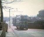
Bradford Trolley Bus on Albion Road
To the west of Greengates is Albion Mills a historic textile mill, destroyed by fire on 10 March 1911 but rebuilt[1][2]
In 1931 the Bradford trolleybus routes were extended from Idle to Greengates[3]
with the service running along Albion Road and Leeds Road.
In 1928 a purpose built 595 seat cinema 'Greengates Cinema' was constructed on New Line.
This closed in 1959 and is now an Asda supermarket.[4]
Governance
Greengates is situated largely in the Idle and Thackley ward and partly in the Eccleshill ward.
It is represented as part of the parliamentary constituency of Bradford East.
Economy

Albion Mills Business Centre (part of)
Greengates' proximity to the Leeds and Liverpool Canal, that runs through Apperley Bridge to the north of the village, has meant that Greengates has several mills.
At the western end is Robin Mills and Albion Mills.
Robin Mills was a base for manufacturing knitting wool yarns but is now split into industrial units.
A large part of Robin Mills is occupied by Storey Evans, carton, leaflet, label etc. printers for the pharmaceutical industry.[5]
Albion Mills is split into office accommodation and business units.
There is the racing car themed Speedmaster Conference Centre, until recently notable for its classic, competition and racing car showroom and exhibition.
The centre was opened in April 2008 by Sir Stirling Moss.[6]
On New Line is the New Line Retail Park with a Subway.
Eastwards between Harrogate Road and New Line in Greengates Retail Park is a Sainsbury's, Homebase, Matalan, Blockbuster, Costa, KFC.[7]
and a Pure Gym.
Existing historic public houses in the area include The Albion and The Hogs Head.[8]
The Seven Stars is now an Italian restaurant, and The Roebuck public house was demolished to make way for a new Farmfoods store.
There is also the Kebabeesh, Kiplings and Paprika restaurants, the China Garden and Empires Chinese takeaways, and two fish and chip shops.
Landmarks
The area is centred on the crossroads of Leeds Road/New Line, and Harrogate Road.
Around this crossroads are most of the area's pubs, restaurants and shops, a Sainsbury's supermarket, Homebase and Matalan.
Another feature is the large war memorial situated at the crossroads, that commemorates those who died in World War I and World War II from Greengates and the surrounding villages.[9][10]
On Harrogate Road to the north of the main crossroads there is a large Anglican church dedicated to St. John the Evangelist.[11]
Also along this stretch of the Harrogate Road is the post office and Optegra Yorkshire Eye Hospital and Bettersight Advanced Eye and Vision Consultancy.[12]
| Old village school, New Line |
| Optegra Yorkshire Eye Hospital, Harrogate Road |
| Church of St. John the Evangelist, Harrogate Road |
|
There are a number of listed buildings in Greengates.[13]
These are to be found at Beck Bottom,[14]
Carr Bottom Rd,[15]
Haigh Hall,[16]
Harrogate Road,[17]
New Line[18]
and Stockhill Fold.[19]
| Greengates House,* Harrogate Road |
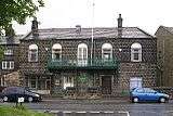
| The Liberal Club,* New Line |
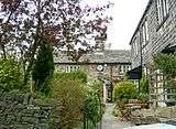
| Listed building at Beck Foot* |
|
| * listed buildings |
Education
Greengates has its own primary school, Greengates Primary School, that moved northwards out of an older building on Leeds Road, to a new building across the road.[20]
The old school building has now been transformed into fashion business premises.
Parkland Primary school, immediately behind Albion Mills, also serves Greengates and the neighbouring Thorpe Edge estate.[21]
Transport
The following bus services run to Greengates;
62: (Centrebus) Cross Green - Greengates via Leysholme and Pudsey,
90: (First Leeds) Leeds Duncan Street - Greengates via Whitehall Road and Troydale,
645: (First Bradford) Buttershaw - Greengates via Five Lane Ends,
670: (First Bradford) Leeds - Bradford via Greengates,
760: (Transdev in Keighley) Leeds - Keighley via Bingley and Saltaire,
747: (Centrebus) [Airport Direct] Bradford - Leeds Bradford Airport and
947: (TLC Travel) Bradford Forster Square - Yeadon Westfield Estate.[22]
The A657 Leeds Road / New Line runs east-west through Greengates while the A658 Harrogate Road runs approximately north-south.[23]
Greengates does not have its own railway station: the nearest station is Apperley Bridge railway station just under a mile to the north.
The nearest airport to Greengates is Leeds Bradford Airport and can be accessed by bus service 747.
References
- ↑ "History of Bradford, Yorkshire - 1900 to 1949". Bradford Timelines. Retrieved 14 March 2010.
- ↑ White, Eileen (1997). Idle Stones. Idle and Thackley Heritage Group.
- ↑ Gould, Peter. "Bradford City Transport: 1898-1974". Bradford Corporation Transport: 1898-1974. Archived from the original on 14 February 2010. Retrieved 14 March 2010.
- ↑ Sutton, Colin. "Bradford - Greengates Cinema History". Bradford Timeline. Retrieved 30 October 2015. ;
"Greengates Cinema in Bradford". Cinema Treasures. Retrieved 28 April 2013.
- ↑ Morris, Helen (23 December 2008). "MY Healthcare strengthens position with Storey Evans acquisition". printweek.com. Archived from the original on 15 July 2011. Retrieved 15 February 2011.
- ↑ "Speedmaster Conference Centre". Destination Bradford. 2008. Retrieved 14 March 2010. ; "Sir Stirling Moss OBE Drove famous Jaguar D-Type through Bradford". Classic Rallies.com. 29 April 2008. Archived from the original on 8 July 2011. Retrieved 14 March 2010.
- ↑ Jack Lunn Group (2008). "Greengates Retail Park". Jack Lunn Construction. Retrieved 28 April 2013.
- ↑ "Pubs in Greengates". Pubs Galore. Retrieved 18 June 2015.
- ↑ Greengates War Memorial. "Greengates War Memorial". Calverley Info. Retrieved 17 July 2008.
- ↑ "Greengates War Memorial". Bradford Parks & Landscape Service. Retrieved 14 March 2010.
- ↑ "Greengates: St John the Evangelist". The Church of England. Retrieved 14 March 2010.
- ↑ Choices, N.H.S. (29 September 2009). "Optegra Eye Hospital Yorkshire". NHS Choices. Retrieved 30 October 2016.
- ↑ "Listed Buildings in Bradford, West Yorkshire, England". British Listed Buildings. Retrieved 10 February 2011.
- ↑ "5". Beck Bottom, British Listed Buildings. Retrieved 11 November 2012.
- ↑ "16-22". ; and "153". Carr Bottom Road, British Listed Buildings. Retrieved 11 November 2012.
- ↑ "2 & 4". ; and "6". Haigh Hall, British Listed Buildings. Retrieved 11 November 2012.
- ↑ "702 & 704". ;
"Coach Ho.". ;
"Greengates War Memorial". ;
"830 Greengates Ho.". ;
"929 & 931". Harrogate Road, British Listed Buildings. Retrieved 11 November 2012.
- ↑ "159". ;
"161, 163 & 165". ;
"169 & 171". ;
"173 & 175 (Greengates Liberal Club)". New Line, British Listed Buildings. Retrieved 11 November 2012.
- ↑ "15 (Stockhill Ho.)". ; "17". ;
"19, 21 & 23". ;
"25 & 27". ;
"29 & 31". ; "33". Stockhill Fold, British Listed Buildings. Retrieved 11 November 2012.
- ↑ "Greengates Primary School, Bradford". greengatesprimary.org.uk. Retrieved 14 March 2010.
- ↑ "Parkland Primary School". 2013. Retrieved 28 April 2013.
- ↑ "62" (PDF). ;
"645" (PDF). ;
"670" (PDF). ;
"747" (PDF). ;
"760" (PDF). ;
"947" (PDF). Service Bus Timetable, West Yorkshire Metro. Retrieved 11 November 2012.
- ↑ Leeds & Bradford A-Z (2 ed.). Geographers' A-Z Map Company Ltd. 2006. ISBN 1-84348-209-6.
External links
 |
Wikimedia Commons has media related to Greengates. |
| Links to related articles |
|---|
|
|
|---|
| Towns,
villages,
areas
and wards | |
|---|
| | Governance | |
|---|
| Culture
and
Tourism | Countryside | |
|---|
| | |
|---|
| Theatres,
halls & cinemas | |
|---|
| Museums | |
|---|
| Organisations | |
|---|
| Shopping | |
|---|
| Parks | |
|---|
| Events | |
|---|
| Heritage | |
|---|
|
|---|
| | Hospitals | |
|---|
| | Education | |
|---|
| | Media | |
|---|
| | Organisations | |
|---|
| | Sport | |
|---|
| | Waterways | |
|---|
| | Transport | |
|---|
| | Miscellaneous | |
|---|
|