Greenville, Mississippi
| Greenville, Mississippi | |
|---|---|
| City | |
 | |
| Nickname(s): The Heart & Soul Of The Delta | |
| Motto: The Best Food, Shopping, & Entertainment In The South | |
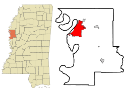 Location of Greenville in Washington County | |
 Greenville, Mississippi Location in the United States | |
| Coordinates: 33°23′55″N 91°2′54″W / 33.39861°N 91.04833°WCoordinates: 33°23′55″N 91°2′54″W / 33.39861°N 91.04833°W | |
| Country | United States |
| State | Mississippi |
| County | Washington |
| Government | |
| • Type | Municipal Government |
| • Mayor | Errick D. Simmons |
| Area | |
| • City | 27.757 sq mi (71.6 km2) |
| • Land | 26.9 sq mi (69.6 km2) |
| • Water | 0.8 sq mi (2.0 km2) |
| Elevation | 131 ft (40 m) |
| Population (United States Census 2010) | |
| • City | 34,400 |
| • Density | 1,279/sq mi (793/km2) |
| • Urban | 34,400 |
| Time zone | CST (UTC-6) |
| • Summer (DST) | CDT (UTC-5) |
| ZIP codes | 38700–38799 |
| Area code(s) | 662 |
| FIPS code | 28-29180 |
| GNIS feature ID | 0670711 |
| Website | www.greenvillems.org |
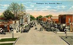
Greenville is a city in Washington County, Mississippi, United States. The population was 34,400 at the 2010 census. It is the county seat of Washington County,[1] located in the area of historic cotton plantations and culture known as the Mississippi Delta.
History
This area was occupied by indigenous peoples when explored by the French, who established a colony at Natchez, Mississippi, the home of the historic Natchez people, and later European-American colonists. The United States Congress passed the Indian Removal Act in 1830, and forced most of the Southeastern tribes to Indian Territory during the following decade.
Greenville was founded in 1824 by William W. Blanton, who filed for land from the United States government. He was granted section four, township eighteen, range eight west. This plot now constitutes most of downtown Greenville.
Greenville became the county seat in 1844. The two previous county seats, New Mexico and Princeton, had both caved into the Mississippi River.[2]
The current city of Greenville is the third in the State to bear the name. The first, located to the south near Natchez, became defunct soon after the American Revolution as European-American settlement was concentrated to the east.
The second is the parent city to the present one and was settled in the early 19th century. It was named by its founders for General Nathanael Greene, beloved friend of George Washington, for whom the county was named. This Greenville was located three miles from the present site. Today it is the site of the city’s industrial fill. The second town was a thriving hamlet in the days before the Civil War. As county seat, it was the trading, business, and cultural center for the large cotton plantations that surrounded it. Most plantations were located directly on the Mississippi and other major navigable tributaries. The interior bottomlands were not developed until after the war.
The town was destroyed during the Union Army's actions related to the siege of Vicksburg. Troops from a Union gunboat landed at Greenville. In retaliation for being fired upon, they burned every building. The inhabitants took refuge in plantation homes of the area. When the war ended, veterans of Mississippi regiments found Greenville in a state of ruin. The former residents soon decided to build again. The place chosen was the highest point on the Mississippi River between the towns of Vicksburg and Memphis. Much of the land then belonged to the Roach and Blanton families; the major part of the area selected was on property owned by Mrs. Harriet Blanton Theobald. She welcomed the idea of a new Greenville, donating land for schools, churches and public buildings. She was called the "Mother of Greenville". Major Richard O’Hea, who had planned the wartime defense fortifications at Vicksburg, was hired to lay out the new town.
Greenville recovered prosperity, still based on cotton, despite its decline. Residences and other buildings from the late 19th and early 20th centuries have been listed on the National Register of Historic Places. It was a center of Delta culture in the early 20th century.
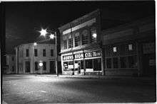
Nelson Street
African Americans in the Delta developed rich varieties of innovative music. Nelson Street is a historic strip of blues clubs that drew crowds in the 1940s and 1950s to the flourishing club scene to hear Delta blues, big band, jump blues and jazz. Record companies came here to recruit talent.[3] It was the equivalent of Beale Street in mid-20th century Memphis.[4]
The Mississippi Blues Commission was established to commemorate this music in Mississippi history and culture; it has identified sites throughout the Delta as part of the Mississippi Blues Trail. Southern Whispers Restaurant on Nelson Street was the second site identified on this trail; this was a stop on the chitlin' circuit in the early days of the blues. The historic marker in front of the restaurant commemorates the importance of this site in the history of the development of the blues in Mississippi.[5][6]
Geography
Greenville is located on the eastern bank of Lake Ferguson, an oxbow lake left from an old channel of the Mississippi River. One floating casino is located on the lake near the downtown area known as the Lighthouse Point Casino, with a second just west of the city near the Greenville Bridge known as Harlow's Casino Resort. Chicago Mill and Lumber Co. operated a lumber mill on the lake two-tenths of a mile south of the casino levee parking lot; the mill specialized in making hardwood boxes until it closed.
According to the United States Census Bureau, the city has a total area of 27.7 square miles (72 km2), of which 26.9 square miles (70 km2) is land and 0.8 square miles (2.1 km2) (2.82%) is water.
Demographics
| Historical population | |||
|---|---|---|---|
| Census | Pop. | %± | |
| 1860 | 760 | — | |
| 1870 | 890 | 17.1% | |
| 1880 | 2,191 | 146.2% | |
| 1890 | 6,658 | 203.9% | |
| 1900 | 7,642 | 14.8% | |
| 1910 | 9,610 | 25.8% | |
| 1920 | 11,560 | 20.3% | |
| 1930 | 14,807 | 28.1% | |
| 1940 | 20,892 | 41.1% | |
| 1950 | 29,936 | 43.3% | |
| 1960 | 41,502 | 38.6% | |
| 1970 | 39,648 | −4.5% | |
| 1980 | 40,613 | 2.4% | |
| 1990 | 45,226 | 11.4% | |
| 2000 | 41,633 | −7.9% | |
| 2010 | 34,400 | −17.4% | |
| Est. 2015 | 32,156 | [7] | −6.5% |
| Sources: 2012 Estimate[9] | |||
As of the 2013 American Community Survey, there were 33,928 people residing in the city. 75.9% were African American, 21.7% White, 0.0% Native American, 0.8% Asian, 0.9% from some other race and 0.7% from two or more races. 1.2% were Hispanic or Latino of any race.
As of the census[10] of 2000, there were 41,633 people, 18,784 households, and 14,422 families residing in the city. The population density was 1,548.8 people per square mile (598.0/km²). There were 16,251 housing units at an average density of 604.6 per square mile (233.4/km²). The racial makeup of the city was 28.92% White, 69.60% Black, 0.07% Native American, 0.71% Asian, 0.01% Pacific Islander, 0.20% from other races, and 0.49% from two or more races. Hispanic or Latino of any race were 0.71% of the population.
There were 14,784 households out of which 35.8% had children under the age of 18 living with them, 37.8% were married couples living together, 27.7% had a female householder with no husband present, and 29.5% were non-families. Of all households, 25.8% were made up of individuals and 10.4% had someone living alone who was 65 years of age or older. The average household size was 2.77 and the average family size was 3.34.
In the city the population was spread out with 31.4% under the age of 18, 10.1% from 18 to 24, 26.3% from 25 to 44, 20.5% from 45 to 64, and 11.8% who were 65 years of age or older. The median age was 32 years. For every 100 females there were 85.4 males. For every 100 females age 18 and over, there were 77.5 males.
The median income for a household in the city was $25,928, and the median income for a family was $30,788. Males had a median income of $29,801 versus $20,707 for females. The per capita income for the city was $13,992. About 25.7% of families and 29.6% of the population were below the poverty line, including 38.2% of those under age 18 and 23.6% of those age 65 or over.
Transportation
Air
Greenville Mid Delta Regional Airport, located in unincorporated Washington County,[11] northeast of downtown Greenville, serves the city and the Mississippi Delta region.
Highway
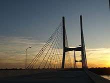
U.S. Highway 82, U.S. Highway 61 and the Great River Road (Mississippi Highway 1) are the main transportation arteries through the Greenville area. U.S. Highway 82 is a major part of the Mississippi Delta's transportation network, as it connects to Interstate 55 and other major four-lane highways. In addition, the U.S. Highway 82 bypass is being constructed to provide a transportation route at the southern end of the Delta, connecting at the new Mississippi River Bridge and ending near Leland. The four-lane Greenville Bridge, a $206 million cable-stayed span crossing the Mississippi River into Arkansas, opened in 2010, replacing the two-lane Benjamin G. Humphreys Bridge, which opened in 1940.
Education
Most of Greenville is served by the Greenville Public School District, while a small portion of the city lies in the Western Line School District.
The private schools, Washington School and Greenville Christian School,[12] also serve the city; as well as the parochial schools, St. Joseph High School [13] and Our Lady of Lourdes Elementary [14] which are part of the Roman Catholic Diocese of Jackson.
The Greenville Higher Education Center offers non-credit community courses and credit courses from Delta State University, Mississippi Delta Community College, and Mississippi Valley State University.[15]
Sports
The Greenville Bucks were a minor-league baseball team in the Cotton States League from 1922 to 1955.
The Greenville Bluesmen were an independent minor league professional baseball team from 1996–2001 in Greenville.
The Mississippi Miracles, formerly the Mississippi Stingers, were an American Basketball Association franchise from 2004–2006 in Greenville.
Greenville will become host to a mega-sports complex for young athletes.
Sites
The Winterville Mounds Historic Site, with more than twelve earthwork mounds constructed by people of the Plaquemine Mississippian culture, is a survival north of the county seat of the deep indigenous history along the Mississippi River. This culture was particularly prominent from 13th to the 15th centuries, long before European exploration. Earthwork mounds were built by peoples in this area from the 9th century. The people in this region were influenced by the larger Mississippian culture, which built similar ceremonial sites throughout the Mississippi Valley and its tributaries. The historic Natchez people are considered the only contemporary surviving group of the Mississippian culture at the time of European exploration.
The Winterville Mounds has been designated as a state park and National Historic Landmark. A museum on the grounds displays artifacts recovered in professional excavations and adds to the interpretation of this complex, and the park has walking trails. It is located about 3 miles north of the city. It can be reached at 2415 Highway 1 N.
Notable people
Born in Greenville
- Steve Azar, country singer.[16]
- John Henry Baker (1934-2015), Louisiana Republican politician from Franklin Parish[17]
- John Colbert, a.k.a. J Blackfoot, Soul singer with the Bar-Kays and Soul Children, was born in Greenville.[18]
- Bruce Blackman, composer/producer, founder of pop group Starbuck; wrote the hit song "Moonlight Feels Right," and produced 8 top 100 singles and 4 albums[19]
- Eden Brent, blues boogie-woogie musician, composer, and performer
- Jo Carr (1926–2007), born Bettye Jo Crisler in Greenville, became one of the first female Methodist ministers and church administrators in the South Plains of Texas. She was first an English professor at Texas Tech University in Lubbock.
- Tommy Davidson, actor/comedian
- Ross Davis, Negro League baseball player
- Tyrone Davis, blues musician
- Shelby Foote, author and historian
- Jimmie Giles, NFL Tight End & four-time Pro Bowl selection in the 1980s while with the Tampa Bay Buccaneers
- Robert T. Henry, World War II soldier and Medal of Honor recipient
- Jim Henson, puppeteer
- Corey Holmes, all-star Canadian Football League player and Mayor of Metcalfe, Mississippi
- Lucy Somerville Howorth, feminist and New Deal lawyer
- Antonio Johnson, NFL player for the Indianapolis Colts
- Germany Kent, model and media personality
- Gabbie McGee, jazz musician.
- Sam Chu Lin, pioneering Chinese American journalist
- John Ramsey Miller, writer and journalist
- The Percy family, including U.S. Senator Le Roy Percy and his son, author William Alexander Percy, lived here. They directed efforts to prevent and recover from the Great Mississippi Flood of 1927. The younger Percy wrote a memoir, Lanterns on the Levee about the Mississippi Delta culture. Walker Percy, another writer from the Percy family, and his brothers were raised by William Alexander Percy here after being orphaned. He lived most of his life in Louisiana.
- George Scott, MLB player for the Boston Red Sox, Milwaukee Brewers, Kansas City Royals and New York Yankees
- Nellie Nugent Somerville, first woman elected to the Mississippi Legislature, mother of Lucy Somerville Howorth
- LaToya Thomas, former professional basketball player in the WNBA, first round draft pick of the Cleveland Rockers
- Frank White, professional baseball player
- Mary Wilson, singer of The Supremes
Greenville-related
- Hodding Carter, Pulitzer Prize-journalist, managed the city's Delta Democrat Times. His descendant Hodding Carter III, also a journalist, lived and worked here during and after the civil rights movement.
- Holt Collier is buried in Greenville. Collier was an African-American bear hunter and sportsman; he served as the guide for President Theodore Roosevelt on a bear hunt in Sharkey County.[20] In January 2004 the Holt Collier National Wildlife Refuge was established on Collier’s "historic hunting grounds" south of Greenville.[21]
- Clarke Reed, Mississippi state Republican chairman from 1966 to 1976, was instrumental in the nomination of Gerald R. Ford, Jr., at the 1976 Republican National Convention, has resided in Greenville since 1950; he is a businessman and investor.[22]
- Leon "Pee Wee" Whittaker, an African-American trombonist, born in Newellton, Louisiana, lived in Greenville early in his career.
Sister cities
-
 Kronach, Germany 2006
 -
 Greenville, Liberia 2009
References
- ↑ "Find a County". National Association of Counties. Archived from the original on 2011-05-31. Retrieved 2011-06-07.
- ↑ Woods, Woody (2010). Delta Plantations: The Beginning. Troy (Woody) Woods. pp. 157, 158.
- ↑ Doe's Eat Place is located on Nelson Street. Cloues, Kacey. "Great Souther Getaways – Mississippi" (PDF). www.atlantamagazine.com. Archived from the original on September 18, 2008. Retrieved 2008-05-31.
- ↑ "Introducing the Mississippi Blues Trail" (PDF). The Mississippi Blues Commission. Retrieved 2008-05-29.
- ↑ "Blues Matters! – Delta sites to be included on new blues trail". www.bluesmatters.com. Retrieved 2008-05-28.
- ↑ "Mississippi Blues Commission – Blues Trail". www.msbluestrail.org. Retrieved 2008-05-28.
- ↑ "Annual Estimates of the Resident Population for Incorporated Places: April 1, 2010 to July 1, 2015". Retrieved July 2, 2016.
- ↑ "U.S. Decennial Census". Census.gov. Archived from the original on May 11, 2015. Retrieved August 21, 2013.
- ↑ "Annual Estimates of the Resident Population: April 1, 2010 to July 1, 2012". Retrieved August 21, 2013.
- ↑ "American FactFinder". United States Census Bureau. Archived from the original on 2013-09-11. Retrieved 2008-01-31.
- ↑ "Greenville city, Mississippi." U.S. Census Bureau. Retrieved on July 15, 2011.
- ↑ Greenville Christian School website
- ↑ "St. Joseph Catholic School, Greenville, Mississippi". stjoeirish.org. Retrieved 21 September 2015.
- ↑ Our Lady of Lourdes Elementary School website
- ↑ Emerson, Melaney. "MDCC – GHEC". ghec.org. Retrieved 21 September 2015.
- ↑ "Steveazar". Steve Azer. Retrieved June 2014. Check date values in:
|access-date=(help) - ↑ "John Henry Baker, III". Findagrave.com. Retrieved May 10, 2016.
- ↑ "Stax star J Blackfoot Dies". The Commercial Appeal. 30 November 2011.
- ↑ "Mississippi Musicians". Mississippi Writer & Musicians. Retrieved June 2014. Check date values in:
|access-date=(help) - ↑ Buchannan, Minor Ferris. "Holt Collier: Guiding Roosevelt through the Mississippi [Canebrake]." U.S. Fish & Wildlife Service Conservation Library
- ↑ "Home – Holt Collier – U.S. Fish and Wildlife Service". fws.gov. Retrieved 21 September 2015.
- ↑ "Sid Salter, GOP pioneer Clarke Reed faces post-crash surgeries, June 25, 2010". DeSoto Times Tribune. Retrieved May 12, 2014.
External links
| Wikivoyage has a travel guide for Greenville (Mississippi). |
| Wikimedia Commons has media related to Greenville, Mississippi. |
- City of Greenville
- Delta Democrat-Times
- History of Greenville's Jewish community (from the Institute of Southern Jewish Life)
-
 "Greenville, a city and the county-seat of Washington county, Mississippi, U.S.A.". Encyclopædia Britannica (11th ed.). 1911.
Municipalities and communities of Washington County, Mississippi, United States | ||
|---|---|---|
| Cities | 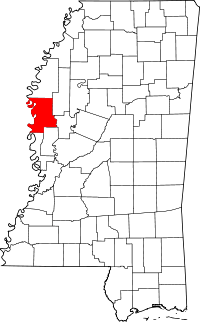 | |
| Towns | ||
| Unincorporated communities | ||
| Ghost towns | ||
.svg.png)