Grey River
| Grey (Māwheranui) | |
| River | |
 Cobden Bridge over the Grey River near its mouth at Greymouth | |
| Name origin: George Grey | |
| Country | New Zealand |
|---|---|
| Region | Tasman, West Coast |
| Cities | Stillwater, Cobden, Greymouth |
| Source | Southern Alps (Saint Arnaud Range) |
| - location | Lake Christabel, New Zealand |
| Mouth | Tasman Sea |
| - elevation | 0 m (0 ft) |
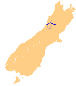 The Grey River system | |
| Wikimedia Commons: Grey River | |
The Grey River / Māwheranui is located in the northwest of the South Island of New Zealand. It rises in Lake Christabel, one of numerous small lakes on the western side of the Southern Alps,12 kilometres southwest of the Lewis Pass, and runs westward for 120 kilometres before draining into the Tasman Sea at Greymouth. The river was named by explorer Thomas Brunner in honour of New Zealand politician Sir George Grey. The official name of the river was changed to Grey River / Māwheranui in 1998 by way of the Ngai Tahu Claims Settlement Act 1998.[1] The Maori name for the river system and surrounding area is Māwhera, with Māwheranui being distinguished from the northern branch Little Grey River / Māwheraiti.[2]
Numerous small rivers are tributaries of the Grey, and several of them also drain lakes. Notable among these are the Ahaura River and the Arnold River, the latter of which is the outflow of Lake Brunner, the largest lake of the northwest South Island. A small hydroelectric station is located on the river 25 kilometres upstream from the mouth of the river.
The Grey River's mouth is protected by a large sandbar, Greymouth bar, which is a notorious danger to shipping.[3]
Raw sewage is discharged into the Grey River after heavy rainfall. Historically, sewage and stormwater from Greymouth, Cobden and Blaketown were discharged without treatment directly into the Grey River. Changes to the Grey District Council's wastewater schemes provide separation and treatment for sewage, except during periods of high rainfall, such as spring, when the capacity of the sewage treatment is exceeded.[4]
Coordinates: 42°26′30″S 171°11′43″E / 42.4417°S 171.1952°E
References
- ↑ "Ngai Tahu Claims Settlement Act 1998". p. 1406. Retrieved 28 March 2011.
- ↑ New Zealand 1:50000 Topographic Map Series sheet BT21 – Waiuta
- ↑ "Greymouth bar braved by experienced fisherman - Video", 3News, 19 January 19, 2011
- ↑ Bromley, Tui (31 October 2012). "Effluent with your whitebait?". The Greymouth Star. The New Zealand Herald. Retrieved 31 October 2012.