Griffith Peak
For another mountain with the same name, see Griffith Peak (Antarctica).
| Griffith Peak | |
|---|---|
 View of Griffith Peak from the top of Trail Canyon | |
| Highest point | |
| Elevation | 11,064 ft (3,372 m) NAVD 88[1] |
| Prominence | 430 ft (131 m) [1] |
| Coordinates | 36°13′57″N 115°38′46″W / 36.2324638°N 115.6461279°WCoordinates: 36°13′57″N 115°38′46″W / 36.2324638°N 115.6461279°W [2] |
| Geography | |
| Location | Clark County, Nevada, U.S. |
| Parent range | Spring Mountains |
| Topo map | USGS Griffith Peak |
| Climbing | |
| Easiest route | Trail hike |
Griffith Peak is located in the Spring Mountains in Clark County of southern Nevada. It is approximately 28 miles (45 km) northwest of the Las Vegas Strip and 3.9 miles (6.3 km) southeast of Mount Charleston.
Griffith Peak is Nevada's 43rd highest peak,[3] and the third highest peak in southern Nevada.[4] It is within Humboldt-Toiyabe National Forest, Mount Charleston Wilderness and Spring Mountains National Recreation Area.
Griffith Peak is accessible by two primary trails: the South Loop Trail and the Harris Springs Trail.[4] The South Loop Trail leads directly to the Griffith Saddle from which both Griffith Peak and Mount Charleston are accessible.
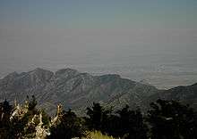
Griffith Peak looking toward Las Vegas
References
| Wikimedia Commons has media related to Griffith Peak. |
- 1 2 "Griffith Peak, Nevada". Peakbagger.com. Retrieved 2008-04-04.
- ↑ "Griffith Peak". Geographic Names Information System. United States Geological Survey. Retrieved 2008-11-22.
- ↑ "Nevada's 11,000-foot Peaks". Peakbagger.com. Retrieved 2008-04-04.
- 1 2 "Griffith Peak". SummitPost.org. Retrieved 2008-04-04.
This article is issued from Wikipedia - version of the 8/24/2016. The text is available under the Creative Commons Attribution/Share Alike but additional terms may apply for the media files.