Grunow-Dammendorf
Grunow-Dammendorf is a municipality in the Oder-Spree district, in Brandenburg, Germany.
Geography
Division of the municipality
Demography
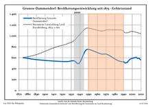
Development of Population since 1875 within the Current Boundaries (Blue Line: Population; Dotted Line: Comparison to Population Development of Brandenburg state; Grey Background: Time of Nazi rule; Red Background: Time of Communist rule)
Grunow-Dammendorf:
Population development within the current boundaries[2]
| Year |
Population |
|
|
|---|
| 1875 | 601 |
| 1890 | 565 |
| 1910 | 539 |
| 1925 | 530 |
| 1933 | 544 |
| 1939 | 499 |
| 1946 | 720 |
| 1950 | 753 |
| 1964 | 671 |
| 1971 | 662 |
|
|
| Year |
Population |
|
|
|---|
| 1981 | 570 |
| 1985 | 539 |
| 1989 | 526 |
| 1990 | 531 |
| 1991 | 515 |
| 1992 | 502 |
| 1993 | 510 |
| 1994 | 509 |
| 1995 | 529 |
| 1996 | 547 |
|
|
| Year |
Population |
|
|
|---|
| 1997 | 565 |
| 1998 | 576 |
| 1999 | 583 |
| 2000 | 591 |
| 2001 | 590 |
| 2002 | 600 |
| 2003 | 598 |
| 2004 | 607 |
| 2005 | 605 |
| 2006 | 587 |
|
|
| Year |
Population |
|
|
|---|
| 2007 | 588 |
| 2008 | 590 |
| 2009 | 570 |
| 2010 | 558 |
| 2011 | 532 |
| 2012 | 525 |
| 2013 | |
|
|
Detailed data sources are to be found in the Wikimedia Commons.[3]
See also
References


