Gučevo
For the village in Bosnia, see Gučevo (Rogatica).
| Gučevo | |
|---|---|
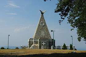 Monument on Crni vrh | |
| Highest point | |
| Elevation | 779 m (2,556 ft) [1] |
| Coordinates | 44°28′50″N 19°11′04″E / 44.48056°N 19.18444°ECoordinates: 44°28′50″N 19°11′04″E / 44.48056°N 19.18444°E |
| Geography | |
 Gučevo Location in Serbia | |
| Location | Western Serbia |
Gučevo (Serbian Cyrillic: Гучево, pronounced [ɡûːt͡ʃɛʋɔ]) is a mountain in western Serbia, near the town of Loznica, overlooking the Drina river and Banja Koviljača. Its highest peak Crni vrh has an elevation of 779 meters above sea level.
The mountain was a site of Battle of Gučevo between Serbian and Austro-Hungarian army in World War I. At the top of the mountain there is a monument to Serbian soldiers.[2]
References
- ↑ Jovan Đokić. "Katalog planina Srbije". PSD Kopaonik Beograd.
- ↑ Gučevo, Banja Koviljača.org
External links
This article is issued from Wikipedia - version of the 11/4/2013. The text is available under the Creative Commons Attribution/Share Alike but additional terms may apply for the media files.