Gulf of Suez
| Gulf of Suez | |
|---|---|
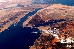 Visible bodies are the Gulf of Suez (west, left in photo), the Gulf of Aqaba (east, right in photo), and the Red Sea (south, bottom left in photo). Photo dated February 2009. | |
 | |
| Location | Egypt |
| Coordinates | 28°45′N 33°00′E / 28.750°N 33.000°ECoordinates: 28°45′N 33°00′E / 28.750°N 33.000°E |
| Max. length | 314 km (195 mi) |
| Max. width | 32 km (20 mi) |
| Average depth | 40 m (130 ft) |
| Max. depth | 70 m (230 ft) |
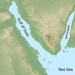
The northern end of the Red Sea bifurcates into the Sinai Peninsula, creating the Gulf of Suez (Arabic: خليج السويس; transliterated: khalīǧ as-suwais; formerly: بحر القلزم, transliterated: baḥar al-qulzum) in the west and the Gulf of Aqaba to the east. The gulf was formed within a relatively young but now inactive Gulf of Suez Rift rift basin, dating back about 28 million years.[1] It stretches some 300 kilometres (190 mi) north by northwest, terminating at the Egyptian city of Suez and the entrance to the Suez Canal. Along the mid-line of the gulf is the boundary between Africa and Asia.[2] The entrance of the gulf lies atop the mature Gemsa oil and gas field.[3]
Geography
The gulf occupies the northwestern arm of the Red Sea between Africa and the Sinai Peninsula. It is the third arm of the triple junction rift system, the second arm being the Gulf of Aqaba.
The length of the gulf, from its mouth at the Strait of Gubal (alternate name: Strait of Jubal)[4] to its head at the city of Suez, is 195 miles (314 km), and it varies in width from 12 to 20 miles (19 to 32 km).
Extent
The International Hydrographic Organization defines the southern limit of the gulf as "A line running from Ras Muhammed (27°43'N) to the South point of Shadwan Island (34°02'E) and thence Westward on a parallel (27°27'N) to the coast of Africa".[5]
Geology
The gulf sedimentary basin stratigraphic section consists of prerift Paleozoic to Oligocene clastic rocks and carbonates, and synrift and postrift Miocene to Holocene clastics and evaporites.[6]:236 Three large oil fields are in the gulf: the El Morgan discovered in 1964, Belayim discovered in 1955, and the October Field discovered in 1977.[6]:238 The October Field produces from the Cretaceous Nubia Formation, the Upper Cretaceous Nezzazat Formation, the Miocene Nukhul Formation, and the Miocene Asl Member of the Upper Rudeis Formation.[6]:236
Ecology
References
- ↑ http://geoinfo.amu.edu.pl/wpk/geos/GEO_2/GEO_PLATE_T-37.HTML Detailed geological information on the Gulf
- ↑ "ISS EarthKAM: Images: Collections: Composite: Gulf of Suez, Egypt and Saudi Arabia".
- ↑ "USGS Open File Report OF99-50-A Red Sea Basin Province (Province Geology)".
- ↑ "Madiq jubal". Tageo.com database of geographic coordinate information.
- ↑ "Limits of Oceans and Seas, 3rd edition" (PDF). International Hydrographic Organization. 1953. Retrieved 7 February 2010.
- 1 2 3 Lelek, J.J., Shepherd, D.B., Stone, D.M., and Abdine, A.S., 1992, October Field, In Giant Oil and Gas Fields of the Decade, 1978-1988, AAPG Memoir 54, Halbouty, M.T., editor, Tulsa: American Association of Petroleum Geologists, ISBN 0891813330
External links
| Wikimedia Commons has media related to Gulf of Suez. |