Guy-Greenbrier earthquake swarm
|
Map of earthquake epicenters for the period August 6, 2010 to March 1, 2011 | |
| Date | 2010–11 |
|---|---|
| Duration | Less than one year |
| Type | Intraplate earthquakes |
| Areas affected | Central Arkansas |
| Greatest magnitude | 4.7 MW |
| Total events | 150-160 earthquakes[1] |
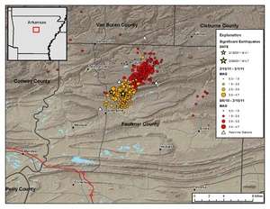
The Guy-Greenbrier earthquake swarm occurred in central Arkansas beginning in August 2010.[2] The epicenters of earthquakes in the swarm showed a linear distribution, with a clear overall shift in activity towards the southwest with time,[3] and the largest event in the swarm was the 2011 Arkansas earthquake, at 4.7 on the moment magnitude scale.[3]
Cause
It has been suggested that the swarm was triggered by drilling activities associated with the exploration and production of shale gas in the Fayetteville Shale in northern Arkansas. Analysis of the swarm has found no link between this relatively shallow drilling and the earthquakes, but has instead suggested a link with deep waste disposal drilling similar to that identified at the Rocky Mountain Arsenal in the 1960s, and has led to a moratorium on such drilling being proposed covering an area of 1150 square miles.[4]
See also
References
- ↑ Peterson, Mark D.; Mueller, Charles S.; Moschetti, Morgan P.; Hoover, Susan M.; Rubinstein, Justin L.; Llenos, Andrea L.; Michael, Andrew J.; Ellsworth, William L.; McGarr, Arthur F.; Holland, Austin A.; Anderson, John G. (April 23, 2015). Incorporating Induced Seismicity in the 2014 United States National Seismic Hazard Model—Results of 2014 Workshop and Sensitivity Studies (USGS Open-File Report 2015–1070) (PDF) (Report). United States Geological Survey. p. 13. doi:10.3133/ofr20151070. ISSN 2331-1258. OCLC 38116130. Retrieved April 23, 2015.
- ↑ http://www.ceri.memphis.edu/GUY/
- 1 2 "Magnitude 4.7 - ARKANSAS". usgs.gov.
- ↑ Short, Louis (June 24, 2011). "Permanent injection well moratorium proposed". The Sun Times. Retrieved 3 July 2011.
Coordinates: 35°17′N 92°22′W / 35.28°N 92.36°W