Gwinear, Cornwall
Coordinates: 50°11′17″N 5°22′16″W / 50.18796°N 5.37115°W

Gwinear (Cornish: Gwynnyer)[1] is a small village in west Cornwall, England, UK. It is about two miles (3 km) east of Hayle[2] and overlooks the Angarrack valley.
Gwinear village sits on a hill with expansive views from the northern end of the village down the Angarrack valley. There is a local pub, the Royal Standard, and a community hall. Gwinear is the church town of Gwinear-Gwithian civil parish.
Church history
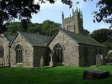
Gwinear church is dedicated to St Winierus (in Irish Fingar), according to legend the leader of the Irish missionaries who came to this district in the 6th century. At Roseworthy there was once a holy well and chapel of the saint, which was also the site of the most splendid Celtic cross of Cornwall (now at Lanherne). The advowson of Gwinear belonged to the manor of Drannack and was sold in 1311 by the Bevilles to Sir Richard de Stapeldon in trust for his brother's foundation at Oxford, later Exeter College.[3]
The parish church of St Gwinear is of the 13th and 14th centuries (tower mid-15th century, built of granite in three stages). There are three aisles: the south aisle which is shorter than the nave, an inner north aisle, and further north the Arundell Aisle.[4] Feast day is held on the first Sunday after 9 May. In 1880 the living was worth approximately £250 per annum and came with a large modern vicarage and a "good glebe". The chapelry at Wall was built in 1828.[5][6]
Malachy Hitchins, astronomer, became Vicar of St Hilary in 1775; in 1785 he also became Vicar of Gwinear and retained both these livings till his death, which took place on 28 March 1809 at St Hilary.
Mining
In the 1840s Gwinear had a number of mines based on two parallel ridges running through the parish in an east-west direction. A large tract of land to the south of the church and vicarage, was part of the Herland mine (also known as the Manor Mine) which had rich deposits of copper, a little tin, and silver ore. A communion plate in use in the parish church in the 1880s was a product of the mine.[7] At that time Gwinear had four public houses, a thriving weekly market and feast was a three-day affair with wrestlers from Lancashire competing with the local men.[7]
Notable buildings
Lanyon Farm and Polkinghorne Farm (both less than a mile from Gwinear Road station) are both 17th century.[8]
References
| Wikimedia Commons has media related to Gwinear–Gwithian. |
- ↑ Place-names in the Standard Written Form (SWF) : List of place-names agreed by the MAGA Signage Panel. Cornish Language Partnership.
- ↑ Ordnance Survey: Landranger map sheet 203 Land's End ISBN 978-0-319-23148-7
- ↑ Cornish Church Guide (1925) Truro: Blackford; p. 106
- ↑ Pevsner, N. (1970) Cornwall, 2nd ed. Penguin Books; pp. 78-79
- ↑ "St Gwinear – Past And Present (Concluded)". The Cornishman (88). 18 March 1880. p. 6.
- ↑ "Correction". The Cornishman (90). 1 April 1880. p. 4.
- 1 2 "Gwinear Past And Present". The Cornishman (87). 11 March 1880. p. 4.
- ↑ Pevsner, N. (1970) Cornwall, 2nd ed. Penguin Books; pp. 78-79
Cornwall Portal | |
| Unitary authorities | |
| Major settlements |
|
| Rivers | |
| Topics | |