Gypsy Camp Historic District
|
Gypsy Camp Historic District | |
|
Main common area of the camp | |
  | |
| Nearest city | Siloam Springs, Arkansas |
|---|---|
| Coordinates | 36°6′44″N 94°32′15″W / 36.11222°N 94.53750°WCoordinates: 36°6′44″N 94°32′15″W / 36.11222°N 94.53750°W |
| Area | 11.5 acres (4.7 ha) |
| Built | 1921 |
| MPS | Benton County MRA |
| NRHP Reference # | 87002425[1] |
| Added to NRHP | January 28, 1988 |
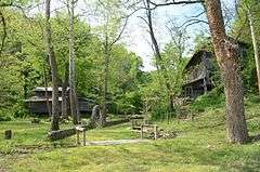
The Gypsy Camp Historic District encompasses a former summer camp facility in rural southwestern Benton County, Arkansas. It is located on the west side of Arkansas Highway 59, about 5 miles (8.0 km) south of Siloam Springs, on the north side of the Illinois River. The camp facilities were built in the 1920s for a girls summer camp, and are believed to be the only facilities built for that purpose in the state. The camp includes four cabins for campers, a dining/recreation hall, and three residential structures. All are finished with either pine slats or board-and-batten siding. There is a centrally-located rock arbor and wall that provide an outside seating area. The camp operated from 1921 to 1978.[2]
The camp was listed on the National Register of Historic Places in 1988.[1]
Gallery
-

Rock Arbor looking out to Illinois River
-

Coe House
-

Vagabond Villa
-

Probably the building known as Gypsy. The upper floor is designated Devil's Den, and the lower floor Angel's Alley
-

-

Ladie's restroom with sleeping quarters behind
-

-

-

Bulletin Board
-

-

Side detail of dining hall
-

Dining hall, front view
-

McAlister Coe house on right
-

Some of the limestone shelters on the property
-

More of the limestone shelters
-

Pool and surrounding pavilions
References
- 1 2 National Park Service (2010-07-09). "National Register Information System". National Register of Historic Places. National Park Service.
- ↑ "NRHP nomination for Gypsy Camp Historic District" (PDF). Arkansas Preservation. Retrieved 2015-02-09.
| Topics | |
|---|---|
| Lists by states |
|
| Lists by insular areas | |
| Lists by associated states | |
| Other areas | |
| |