HMS Bittern (L07)
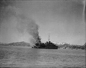 HMS Bittern ablaze in Namsos Fjord after having suffered a direct hit in the stern by a bomb. | |
| History | |
|---|---|
| Name: | HMS Bittern |
| Builder: | J. Samuel White, Cowes, Isle of Wight |
| Laid down: | 27 August 1936 |
| Launched: | 14 July 1937 |
| Commissioned: | 15 March 1938 |
| Identification: | pennant number: L07 |
| Fate: | Sunk by German bombers, 30 April 1940 |
| General characteristics [1] | |
| Class and type: | Bittern-class sloop |
| Displacement: | 1,190 tons |
| Length: | 266 ft (81 m) |
| Beam: | 37 ft (11 m) |
| Propulsion: | Geared steam turbines on two shafts, 3,300 hp |
| Speed: | 18.75-knot (34.73 km/h) |
| Complement: | 125 |
| Armament: |
|
HMS Bittern was a Bittern-class sloop of the Royal Navy. Although the last to be completed she was the name ship of her class, replacing an earlier Bittern which had been re-named before launch. Bittern was laid down on 27 August 1936 by J. Samuel White, of Cowes, Isle of Wight, launched on 14 July 1937 and completed on 15 March 1938.
She served in Home waters and off the coast of Norway during the Second World War. She took part in the ill-fated Namsos Campaign of 1940, where she was used to defend allied troop ships entering and leaving Namsos harbour from submarine attacks. The harbour came under regular air attack by the Luftwaffe, and on 30 April, Bittern was spotted and mistaken for an Allied cruiser by a squadron of Junkers Ju 87 dive bombers. Bittern came under repeated attack from 0700 hours onwards. She was hit repeatedly and severely damaged, being set on fire. Nearby allied ships came alongside and took the survivors off. When this had been completed, Bittern was sunk by a torpedo from the destroyer Janus.[2]
In 2011 it was reported that the ship has started to leak oil and contained roughly 200,000 litres (44,000 imp gal; 53,000 US gal) of oil.[3]
Notes
- ↑ Conway p57
- ↑ Mason, Geoffrey B. (2005). "HMS Janus (F.53) - J-class Destroyer". naval-history.net. Retrieved 23 June 2015.
- ↑ "Gammalt brittiskt vrak har börjat läcka olja" (in Swedish). HBL.fi. 21 July 2011. Retrieved 15 February 2015.
References
- R Gardiner, R Gray : Conway's All the World's Fighting Ships: 1906–1921 (1985) ISBN 0-85177-245-5
- Hague, Arnold (1993). Sloops: A History of the 71 Sloops Built in Britain and Australia for the British, Australian and Indian Navies 1926–1946. Kendal, England: World Ship Society. ISBN 0-905617-67-3.
External links
- HMS Bittern at navalhistory.net
- HMS Bittern at uboat.net
- HMS Bittern at britainsnavy.co.uk
- A report on the situation in Namsen Fjord that day
| Shipwrecks |
|
|---|---|
| Other incidents |
|
1939 March 1940 | |
Coordinates: 64°28′N 11°30′E / 64.467°N 11.500°E