Haderslev Municipality
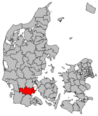
Haderslev (German: Hadersleben) is a town and municipality on the east coast of the Jutland peninsula in the Region of Southern Denmark. It includes the island of Årø as well as several other smaller islands in the Little Belt. The municipality covers 701.98 km2 (271 sq mi) and has a population of 56,414 (2008). Its mayor is Jens Christian Gjesing, representing the Social Democratic Party. Due to Kommunalreformen ("The Municipal Reform" of 2007), Haderslev municipality was merged on January 1 of that year with the former municipalities of Gram and Vojens, as well as Bjerning, Hjerndrup, and Fjelstrup parishes of Christiansfeld Municipality and Bevtoft parish of Nørre Rangstrup Municipality. The municipality makes up most of the southern part of the East Jutland metropolitan area, which has 1.2 million inhabitants.[1]
The waters of Haderslev Fjord cut into the municipality from the Little Belt, dividing the city north-to-south, becoming Haderslev Dam west of the city centre. Årø Strait (Årøsund) separates the bulk of the municipality from the island of Årø, and the two are connected by ferry service between the town of Årøsund on the mainland and the town of Årø on the island.
The city of Haderslev
The main town and the site of the municipal council is the city of Haderslev.
References
- Municipal statistics: NetBorger Kommunefakta, delivered from KMD aka Kommunedata (Municipal Data)
- Municipal mergers and neighbours: Eniro new municipalities map
- Notes
External links
- Municipality's official website (Danish only)
- Haderslev tourism information in English
- The new Haderslev municipality's official website (Danish only)

Coordinates: 55°15′N 9°30′E / 55.250°N 9.500°E