Hallett Peninsula
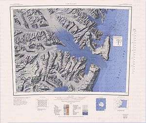
Hallett Peninsula (72°30′S 170°10′E / 72.500°S 170.167°ECoordinates: 72°30′S 170°10′E / 72.500°S 170.167°E) is a triangular, dome-shaped peninsula, 20 nautical miles (37 km) long, with 1,500-metre (4,900 ft) cliffs on its eastern seaboard side and 300-metre (1,000 ft) on its west side. The peninsula extends from Cape Hallett to Cape Wheatstone and is joined to the mainland by a narrow ridge between Tucker Glacier and Edisto Inlet. It was so named by the New Zealand Geological Survey Antarctic Expedition, 1957–58, because Hallett Station on Seabee Hook was established at the north end of the peninsula.[1]
References
- ↑ "Hallet Peninsula". Geographic Names Information System. United States Geological Survey. Retrieved 2012-05-17.
![]() This article incorporates public domain material from the United States Geological Survey document "Hallett Peninsula" (content from the Geographic Names Information System).
This article incorporates public domain material from the United States Geological Survey document "Hallett Peninsula" (content from the Geographic Names Information System).