Halsanaustan
| Halsanaustan Halsa | |
|---|---|
| Village | |
|
View of Halsa, near the ferry | |
 Halsanaustan  Halsanaustan Location in Møre og Romsdal | |
| Coordinates: 63°04′18″N 08°15′03″E / 63.07167°N 8.25083°ECoordinates: 63°04′18″N 08°15′03″E / 63.07167°N 8.25083°E | |
| Country | Norway |
| Region | Western Norway |
| County | Møre og Romsdal |
| District | Nordmøre |
| Municipality | Halsa Municipality |
| Elevation[1] | 47 m (154 ft) |
| Time zone | CET (UTC+01:00) |
| • Summer (DST) | CEST (UTC+02:00) |
| Post Code | 6680 Halsanaustan |
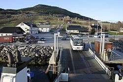
Halsanaustan or just Halsa is a village in Halsa Municipality in Møre og Romsdal county, Norway. The village is located along the European route E39 highway on an isthmus of a small peninsula between the Halsafjorden and the Skålvik Fjord, about 10 kilometres (6.2 mi) southwest of the municipal center of Liabøen. There is a ferry from Halsanausta to Kanestraum in Tingvoll Municipality, across the Halsafjorden. Halsa Church is located in this village.
References
This article is issued from Wikipedia - version of the 8/1/2016. The text is available under the Creative Commons Attribution/Share Alike but additional terms may apply for the media files.