Hamars
| Hamars | |
|---|---|
 | |
 Hamars | |
|
Location within Normandy region  Hamars | |
| Coordinates: 48°59′57″N 0°32′42″W / 48.9992°N 0.545°WCoordinates: 48°59′57″N 0°32′42″W / 48.9992°N 0.545°W | |
| Country | France |
| Region | Normandy |
| Department | Calvados |
| Arrondissement | Caen |
| Canton | Thury-Harcourt |
| Intercommunality | Suisse Normande |
| Government | |
| • Mayor (2008–2014) | Jean-Claude Leclerc |
| Area1 | 9.44 km2 (3.64 sq mi) |
| Population (2008)2 | 420 |
| • Density | 44/km2 (120/sq mi) |
| Time zone | CET (UTC+1) |
| • Summer (DST) | CEST (UTC+2) |
| INSEE/Postal code | 14324 / 14220 |
| Elevation |
67–272 m (220–892 ft) (avg. 252 m or 827 ft) |
|
1 French Land Register data, which excludes lakes, ponds, glaciers > 1 km² (0.386 sq mi or 247 acres) and river estuaries. 2 Population without double counting: residents of multiple communes (e.g., students and military personnel) only counted once. | |
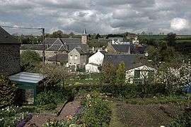
Hamars is a former commune in the Calvados department in the Normandy region in northwestern France. On 1 January 2016, it was merged into the new commune of Le Hom.[1]
Population
| Historical population | ||
|---|---|---|
| Year | Pop. | ±% |
| 1962 | 274 | — |
| 1968 | 232 | −15.3% |
| 1975 | 231 | −0.4% |
| 1982 | 346 | +49.8% |
| 1990 | 343 | −0.9% |
| 1999 | 390 | +13.7% |
| 2008 | 420 | +7.7% |
See also
References
- ↑ Arrêté préfectoral 22 December 2015 (French)
| Wikimedia Commons has media related to Hamars. |
This article is issued from Wikipedia - version of the 3/22/2016. The text is available under the Creative Commons Attribution/Share Alike but additional terms may apply for the media files.