Hamburg Metropolitan Region
| Hamburg Metropolitan Region Metropolregion Hamburg | ||
|---|---|---|
| ||
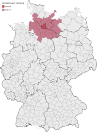 location of the Hamburg Metropolitan Region in Germany | ||
| Country |
| |
| States |
| |
| Largest Cities | Hamburg | |
| Area | ||
| • Metro | 26,000 km2 (10,000 sq mi) | |
| Population [1] | ||
| • Metro | 5,100,000 | |
| • Metro density | 192/km2 (500/sq mi) | |
| Time zone | CET (UTC+1) | |
| Website | http://www.metropolregion.hamburg.de/ | |
The Metropolregion Hamburg (German for Hamburg Metropolitan Region) is the compilation of eight districts in the German federal state of Lower Saxony, six districts in Schleswig-Holstein, two districts in Mecklenburg-Vorpommern and the city-state of Hamburg in northern Germany. It covers an area of ca 26,000 square kilometres (10,000 sq mi), and is home to more than 5.1 million inhabitants.
History
On 1 January 2006, the office of the Hamburg metropolitan region opened, as agreed in a state treaty of cooperation (Staatsvertrag über Zusammenarbeit) between Hamburg, Lower Saxony and Schleswig-Holstein.[2]
Geography
In 2005, the Hamburg metropolitan region consisted of the city-state Hamburg, rural districts of Lower Saxony, and districts of Schleswig-Holstein, with more than 800 cities, towns or municipalities. The region covered an area of 19,802 square kilometres (7,646 sq mi).[3] It was later extended with an area of the Ludwigslust-Parchim district and the Nordwestmecklenburg district of Mecklenburg-Vorpommern.
|
States and districts
|
Largest cities and towns
| ||||||||||||||||||||||||||||||||||||||||||||||||||||||||||||||||||||||||||||||||||||||||||||||||||||||||||||||||||||||||||||||||||||||||||||||||||||||||||||||||||||||||||||||||||
* Districts and District free cities (German: Kreisfreie Städte).
† Ludwigslust was merged into Ludwigslust-Parchim in 2011; pop. data for 2010
Larger Urban Zones


The Hamburg Larger Urban Zone (LUZ) as defined by Eurostat's Urban Audit covers an area of 7,303 km² and in 2004 contained 3,134,620 inhabitants[6] (pop. density 429/km²). The Larger Urban Zone covers the Free and Hanseatic city of Hamburg and only the directly bordering districts:[7] The Hamburg LUZ corresponds with the service area of Hamburger Verkehrsverbund (HVV). only in these areas, the population density is 150 inhabitants/km2 or higher.
| State | District* | Population (2012) |
Area |
Pop. density (2012) |
|---|---|---|---|---|
| | – | 1,813,587 | 755 km2 | 2,400/km2 |
| | Harburg | 239,269 | 1,245 km2 | 190/km2 |
| Stade | 195,606 | 1,266 km2 | 150/km2 | |
| | Lauenburg | 187,905 | 1,263 km2 | 150/km2 |
| Pinneberg | 298,826 | 664 km2 | 450/km2 | |
| Segeberg | 261,988 | 1,334 km2 | 200/km2 | |
| Stormarn | 232,911 | 766 km2 | 300/km2 | |
| Hamburg LUZ[8][9] | 2,903,198 | |||
| | Lübeck | 211,713 | 214.13 km2 | 990/km2 |
| Ostholstein | 197,882 | 1,391 km2 | 140/km2 | |
| Lübeck LUZ[8][9] | 391,373 | |||
| | Bremerhaven† | 112,895 | 78,87 km2 | 1,400/km2 |
| | Cuxhaven | 198,115 | 2,073 km2 | 96/km2 |
| Bremerhaven LUZ[8][9] | 288,635 | |||
* Districts and District free cities (German: Kreisfreie Städte).
† not part of the Hamburg Metropolitan Region
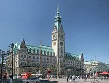 Hamburg City Hall (Rathaus), seat of the Hamburg Senate
 Lübeck's seaside resort Travemünde
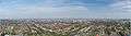
 Wismar, World Heritage old town
See also
References
- ↑ "Hamburg" (in German). Retrieved 12 June 2009.
- ↑ Impressum - metroploregion Hamburg (in German), retrieved 25 March 2009
- ↑ Hamburg Metropolitan Area fact sheet (PDF), Statistical office Hamburg and Schleswig-Holstein (Statistisches Amt für Hamburg und Schleswig-Holstein), 2006, retrieved 25 March 2009
- ↑ Bevölkerungsstand und Bevölkerungsdichte am 31.12.2012, Metropolregion Hamburg, 2013
- ↑ Flächennutzung: Siedlungs- und Verkehrsfläche nach Art der tatsächlichen Nutzung am 31.12.2012, Metropolregion Hamburg, 2013
- ↑ "Hamburg". Archived from the original on 15 July 2011. Retrieved 15 June 2009.
- ↑ http://www.staedtestatistik.de/508.html Retrieved 15 June 2009.
- 1 2 3 Population by larger urban zone, eurostat, 2014
- 1 2 3 Map of metro regions, eurostat, 2012
External links
- Metropolregion Hamburg - official webpage
Freie und Hansestadt Hamburg | |
| Government and Symbols | |
| History and Culture | |
| Economy and Transport | |
Coordinates: 53°30′N 10°00′E / 53.5°N 10.0°E