Hanger Lane tube station
| Hanger Lane | |
|---|---|
|
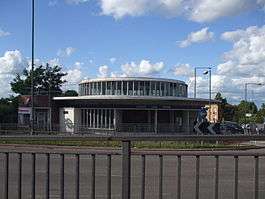
Station building | |
 Hanger Lane Location of Hanger Lane in Greater London | |
| Location | Hanger Hill |
| Local authority | London Borough of Ealing |
| Managed by | London Underground |
| Number of platforms | 2 |
| Fare zone | 3 |
| OSI | Park Royal [1] |
| London Underground annual entry and exit | |
| 2012 |
|
| 2013 |
|
| 2014 |
|
| 2015 |
|
| Key dates | |
| 1947 | Opened |
| Other information | |
| Lists of stations | |
| WGS84 | 51°31′49″N 0°17′35″W / 51.530278°N 0.293056°WCoordinates: 51°31′49″N 0°17′35″W / 51.530278°N 0.293056°W |
|
| |
Hanger Lane is a London Underground station in Hanger Hill, Ealing, on the border between West and Northwest London. It is located on the West Ruislip branch of the Central line, between Perivale and North Acton stations, and is in Travelcard Zone 3.
It is within walking distance of Park Royal station on the Piccadilly line. The two lines cross a little east of Hanger Lane station.
History
The Great Western Railway (GWR) opened Twyford Abbey Halt just east of the site on 1 May 1904 as part of the GWR and Great Central Railway Joint Railway project (the New North Main Line) towards High Wycombe. It was closed on 1 May 1911, replaced by Brentham station, later renamed "Brentham (for North Ealing)", to the west of the present location. That station was closed between 1915 and 1920 due to World War I economies. Brentham and most main-line stations between North Acton and West Ruislip were finally closed in 1947 when the Central line was extended from North Acton on electrified tracks built under the LTPB New Works Programme of 1935, the delay was due to World War II.
The Central line station opened on 30 June 1947 as "Hanger Lane" as it was near that road.
The entrance and roof of the subsurface ticket hall form the centre of the Hanger Lane Gyratory System, a complex roundabout in West London where the A40 Western Avenue crosses the A406 North Circular Road in an underpass. Passengers must use pedestrian subways under the gyratory to access the station, which is itself above ground.
Development
In 2004 the multinational Diageo company agreed to build extra Central line platforms at Park Royal tube station to the east,[3][4] as part of its First Central business park,[5] built on the site of the (now demolished) Guinness brewery. As of February 2013, this has not happened.
In 2012 the station building exterior was repainted, refurbished and given new London Underground roundels.
Connections
London Buses routes 95, 112, 226, 483 and 487 serve the station.
Gallery
| Wikimedia Commons has media related to Hanger Lane tube station. |
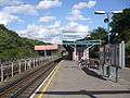 Looking eastwards
 Looking westwards
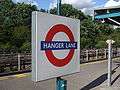 Roundel on westbound platform face.
References
- ↑ "Out of Station Interchanges" (XLS). Transport for London. May 2011. Archived from the original on 20 October 2012.
- 1 2 3 4 "Multi-year station entry-and-exit figures" (XLS). London Underground station passenger usage data. Transport for London. April 2016. Retrieved 3 May 2016.
- ↑ alwaystouchout Park Royal Central line platforms
- ↑ London Borough of Brent: Central line agreement Audit trail for planning agreement not all on-line, but starts here
- ↑ First Central business park Map of Park Royal Central line platforms
| Preceding station | Following station | |||
|---|---|---|---|---|
towards West Ruislip | Central line |
| Stations |
| ||||||||||||||||||||||||
|---|---|---|---|---|---|---|---|---|---|---|---|---|---|---|---|---|---|---|---|---|---|---|---|---|---|
| Rolling stock | |||||||||||||||||||||||||
| History |
| ||||||||||||||||||||||||
| Proposed stations | |||||||||||||||||||||||||
| Depots | |||||||||||||||||||||||||
| |||||||||||||||||||||||||