Haregī, Iran
| Haregī | |
|---|---|
| village | |
 Haregī | |
| Coordinates: 25°41′00″N 59°19′00″E / 25.68333°N 59.31667°ECoordinates: 25°41′00″N 59°19′00″E / 25.68333°N 59.31667°E | |
| Country |
|
| Province | Sīstān va Balūchestān |
| County | Chabahar County |
| Elevation | 10 m (30 ft) |
| Time zone | IRST (UTC+3:30) |
| • Summer (DST) | IRDT (UTC+4:30) |
Haregī, also known as Hargī, or Harqī[1] is a town in the Province of Sīstān va Balūchestān, Iran.
Located at Latitude 25.4906°N and Longitude 59.2967° E, the village is located on the Iranian coast looking over the Gulf of Oman, and is 210km from the port of Jask, and about 150 km from the Port of Chabahar, the county capital.
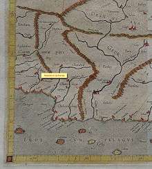
The village sits aside an ephemeral stream that some[2] have identified with the Salarus River which Ptolemy though was the site of Alexandria Carmania.
References
- ↑ Traveling Luck for Haregī, Sīstān va Balūchestān, Iran
- ↑ Edward Thomas, The Royal Asiatic Society (Oxford University, 1879) page 148
This article is issued from Wikipedia - version of the 9/22/2016. The text is available under the Creative Commons Attribution/Share Alike but additional terms may apply for the media files.